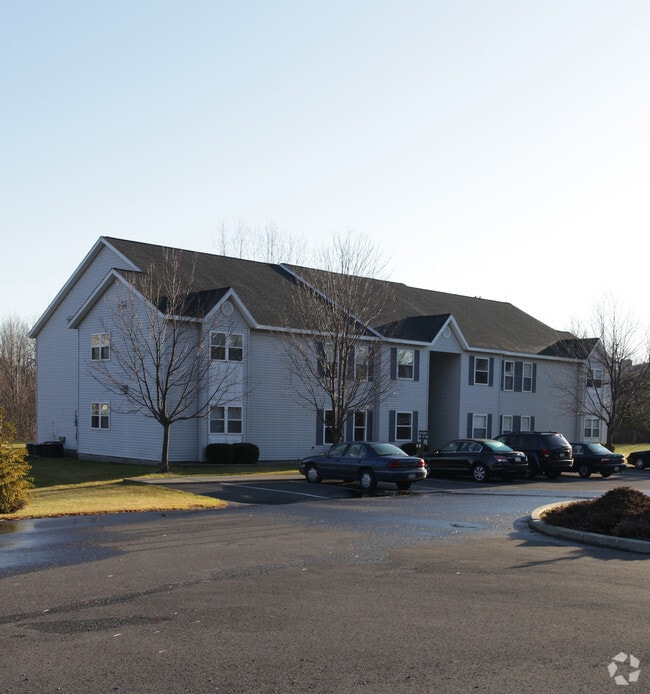
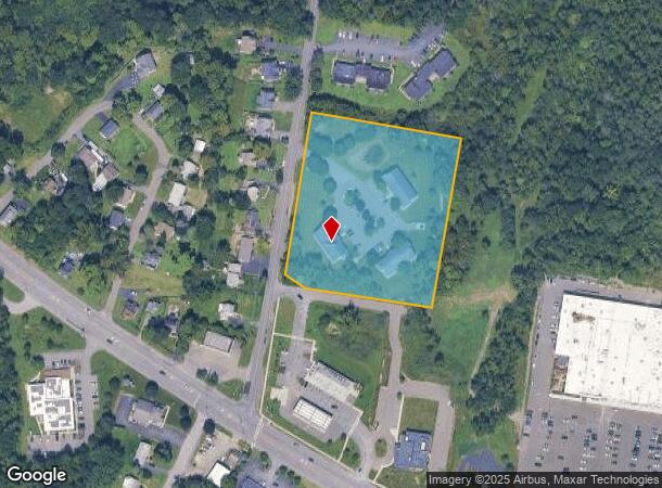
Property Record
15 Swatling Rd, Watervliet, NY 12189
NEARBY LISTINGS FOR SALE OR LEASE
Property Detail
15 Swatling Rd
012689-032-001-0002-002-000-0000
N-19 E-183 TROY SCHDY RD C-71-71.9
Apartment
Albany
X
New York
36001C0201D
2.000
2025
4.18 AC
2024
Outer Albany County
013300
Albany/Schenectady/Troy
8,228 SF
Albany-Schenectady-Troy, NY
DEMOGRAPHICS near 15 Swatling Rd
1 Mile
3 Mile
5 Mile
2024 Total Population
9,616
78,358
162,555
2029 Population
9,627
77,398
160,754
Pop Growth 2024-2029
+ 0.11%
(1.23%)
(1.11%)
Average Age
43
40
40
2024 Total Households
4,144
33,391
68,946
HH Growth 2024-2029
+ 0.17%
(1.33%)
(1.20%)
Median Household Inc
$81,045
$64,800
$69,077
Avg Household Size
2.20
2.20
2.20
2024 Avg HH Vehicles
2.00
1.00
1.00
Median Home Value
$283,904
$255,626
$241,827
Median Year Built
1983
1959
1961
Nearby Places
- Restaurants
- Banks
- Shops
- Fitness
- Groceries
PUBLIC TRANSPORTATION
AIRPORT
Albany International
DRIVE
WALK
Distance
Albany International
9 min
4.0 mi
Freight Ports
Albany, NY Port
DRIVE
WALK
Distance
Albany, NY Port
1 min
8.0 mi
Nearby Properties
Address
Land Use
TOTAL SIZE
Lot Size
Zoning
Address
Land Use
TOTAL SIZE
Lot Size
Zoning
34,971 SF
108.68 AC
CI
Address
Land Use
TOTAL SIZE
Lot Size
Zoning
18,340 SF
159.79 AC
04 - FARM
Address
Land Use
TOTAL SIZE
Lot Size
Zoning
9,643 SF
5.36 AC
CI
Address
Land Use
TOTAL SIZE
Lot Size
Zoning
326,350 SF
11.11 AC
I
Address
Land Use
TOTAL SIZE
Lot Size
Zoning
154,580 SF
89.34 AC
16
Address
Land Use
TOTAL SIZE
Lot Size
Zoning
365,400 SF
73.90 AC
04 - FARM
Address
Land Use
TOTAL SIZE
Lot Size
Zoning
38,176 SF
8.99 AC
06 - INDUS
Address
Land Use
TOTAL SIZE
Lot Size
Zoning
3,214 SF
412.83 AC
18
Address
Land Use
TOTAL SIZE
Lot Size
Zoning
70,548 SF
2.71 AC
DMU
Address
Land Use
TOTAL SIZE
Lot Size
Zoning
82,154 SF
3.62 AC
DMU
Address
Land Use
TOTAL SIZE
Lot Size
Zoning
226,171 SF
26.39 AC
12
Address
Land Use
TOTAL SIZE
Lot Size
Zoning
242,630 SF
18.50 AC
16
Address
Land Use
TOTAL SIZE
Lot Size
Zoning
18,144 SF
58.78 AC
25
Address
Land Use
TOTAL SIZE
Lot Size
Zoning
84,242 SF
43.60 AC
12
Address
Land Use
TOTAL SIZE
Lot Size
Zoning
501,506 SF
48 AC
01 - NOT Z
Address
Land Use
TOTAL SIZE
Lot Size
Zoning
223,050 SF
85.68 AC
04 - FARM
Address
Land Use
TOTAL SIZE
Lot Size
Zoning
353,510 SF
2.94 AC
WMU
Address
Land Use
TOTAL SIZE
Lot Size
Zoning
10,271 SF
11.22 AC
05 - COMME
Address
Land Use
TOTAL SIZE
Lot Size
Zoning
264,473 SF
26.40 AC
25
Address
Land Use
TOTAL SIZE
Lot Size
Zoning
251,672 SF
16.18 AC
06 - INDUS
Address
Land Use
TOTAL SIZE
Lot Size
Zoning
135,396 SF
19.81 AC
12
Address
Land Use
TOTAL SIZE
Lot Size
Zoning
151,287 SF
11.20 AC
12
Address
Land Use
TOTAL SIZE
Lot Size
Zoning
Address
Land Use
TOTAL SIZE
Lot Size
Zoning
73,736 SF
7.58 AC
14
Address
Land Use
TOTAL SIZE
Lot Size
Zoning
9,792 SF
7.98 AC
R3
Address
Land Use
TOTAL SIZE
Lot Size
Zoning
87,427 SF
20.30 AC
R1A
Address
Land Use
TOTAL SIZE
Lot Size
Zoning
77,928 SF
2.25 AC
WMU
Address
Land Use
TOTAL SIZE
Lot Size
Zoning
93,373 SF
4.50 AC
02 - SINGL
Address
Land Use
TOTAL SIZE
Lot Size
Zoning
105,094 SF
3.38 AC
MF
The World's #1 Commercial Real Estate Marketplace
Connect with us
© 2025 CoStar Group
The information above has been obtained from sources believed reliable. While we do not doubt its accuracy we have not verified it and make no guarantee, warranty or representation about it. It is your responsibility to independently confirm its accuracy and completeness. Any projections, opinions, assumptions, or estimates used are for example only and do not represent the current or future performance of the property. The value of this transaction to you depends on tax and other factors which should be evaluated by your tax, financial, and legal advisors. You and your advisors should conduct a careful, independent investigation of the property to determine to your satisfaction the suitability of the property for your needs.