No Photo
Property Record
15 Taylor Rd, Mount Vernon, OH 43050

Save to a Folder
{{folder.Name}}
{{folder.ListingIds.length}} Properties
{{folder.ListingIds.length}} Property
Create a New Folder
Property Detail
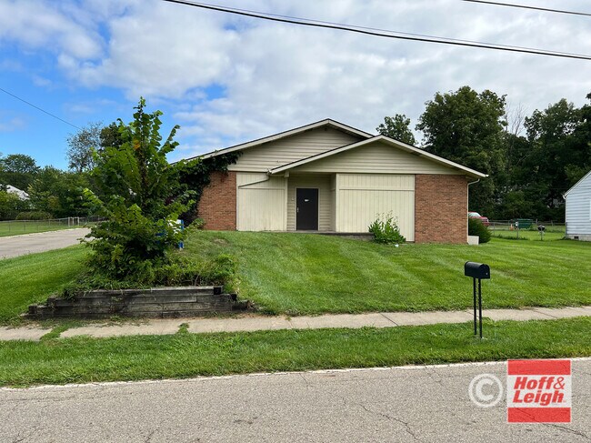
15 Taylor Rd
Mount Vernon, OH
CHARLES HEIGHTS 83 1 6 W SIDE
66-50472.000
KNOX
Commercialnec
Ohio
B and X Area of moderate flood hazard, usually the area between the limits of the 100-year and 500-year floods.
0.03 AC
2025
Ohio North Area
2025
Other Market Areas
007200
NEARBY LISTINGS FOR SALE OR LEASE
-
-
View all Mount Vernon listings for sale on LoopNet.com
DEMOGRAPHICS near 15 Taylor Rd
1 mile
3 mile
5 mile
2025 Total Population
7,636
21,044
27,105
2030 Population
7,747
21,405
27,517
Pop Growth 2025-2030
+ 1.45%
+ 1.72%
+ 1.52%
Average Age
40
41
41
2025 Total Households
3,317
8,661
10,643
HH Growth 2025-2030
+ 1.42%
+ 1.75%
+ 1.59%
Median Household Inc
$49,601
$56,869
$61,482
Avg Household Size
2.20
2.20
2.30
2025 Avg HH Vehicles
2.00
2.00
2.00
Median Home Value
$169,554
$181,124
$195,553
Median Year Built
1957
1960
1963
Nearby Places
Map Layers
Map Styles
 Street
 Aerial
Layers
 Traffic
 Biking
Places
Listings with unknown addresses are not visible on the map
- Restaurants
- Banks
- Shops
- Fitness
- Groceries
SALE & LEASE HISTORY
LISTING DATE
SALE/LEASE

Aug 20, 2024
For Sale
Nearby Properties
Address
Land Use
TOTAL SIZE
Lot Size
Zoning
Address
Land Use
TOTAL SIZE
Lot Size
Zoning
6,856 SF
106.31 AC
Address
Land Use
TOTAL SIZE
Lot Size
Zoning
118,756 SF
80 AC
Address
Land Use
TOTAL SIZE
Lot Size
Zoning
95,818 SF
4.51 AC
Address
Land Use
TOTAL SIZE
Lot Size
Zoning
4,238 SF
11.38 AC
Address
Land Use
TOTAL SIZE
Lot Size
Zoning
88,043 SF
11.54 AC
Address
Land Use
TOTAL SIZE
Lot Size
Zoning
14,968 SF
19.69 AC
Address
Land Use
TOTAL SIZE
Lot Size
Zoning
Address
Land Use
TOTAL SIZE
Lot Size
Zoning
Address
Land Use
TOTAL SIZE
Lot Size
Zoning
120,513 SF
22.50 AC
Address
Land Use
TOTAL SIZE
Lot Size
Zoning
48,700 SF
12.06 AC
Address
Land Use
TOTAL SIZE
Lot Size
Zoning
1,303 SF
0.10 AC
Address
Land Use
TOTAL SIZE
Lot Size
Zoning
126,416 SF
21.20 AC
Address
Land Use
TOTAL SIZE
Lot Size
Zoning
102,480 SF
18.21 AC
Address
Land Use
TOTAL SIZE
Lot Size
Zoning
Address
Land Use
TOTAL SIZE
Lot Size
Zoning
56,768 SF
62.58 AC
Address
Land Use
TOTAL SIZE
Lot Size
Zoning
5,613 SF
15.22 AC
Address
Land Use
TOTAL SIZE
Lot Size
Zoning
18,328 SF
9.18 AC
Address
Land Use
TOTAL SIZE
Lot Size
Zoning
57,271 SF
102.03 AC
Address
Land Use
TOTAL SIZE
Lot Size
Zoning
281,700 SF
6.72 AC
Address
Land Use
TOTAL SIZE
Lot Size
Zoning
28,872 SF
0.14 AC
Address
Land Use
TOTAL SIZE
Lot Size
Zoning
95,336 SF
12.99 AC
Address
Land Use
TOTAL SIZE
Lot Size
Zoning
65,802 SF
1.03 AC
Address
Land Use
TOTAL SIZE
Lot Size
Zoning
47,923 SF
7.38 AC
Address
Land Use
TOTAL SIZE
Lot Size
Zoning
38,181 SF
7.26 AC
Address
Land Use
TOTAL SIZE
Lot Size
Zoning
21,399 SF
0.25 AC
Address
Land Use
TOTAL SIZE
Lot Size
Zoning
271,356 SF
9.63 AC
Address
Land Use
TOTAL SIZE
Lot Size
Zoning
48,821 SF
0.20 AC
Address
Land Use
TOTAL SIZE
Lot Size
Zoning
70,674 SF
4.76 AC
Address
Land Use
TOTAL SIZE
Lot Size
Zoning
19,721 SF
6.16 AC
Address
Land Use
TOTAL SIZE
Lot Size
Zoning
The World's #1 Commercial Real Estate Marketplace
Connect with us
© 2026 CoStar Group
The information above has been obtained from sources believed reliable. While we do not doubt its accuracy we have not verified it and make no guarantee, warranty or representation about it. It is your responsibility to independently confirm its accuracy and completeness. Any projections, opinions, assumptions, or estimates used are for example only and do not represent the current or future performance of the property. The value of this transaction to you depends on tax and other factors which should be evaluated by your tax, financial, and legal advisors. You and your advisors should conduct a careful, independent investigation of the property to determine to your satisfaction the suitability of the property for your needs.