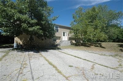
Property Record
15 Trolley Rd, Montrose, NY 10548
NEARBY LISTINGS FOR SALE OR LEASE
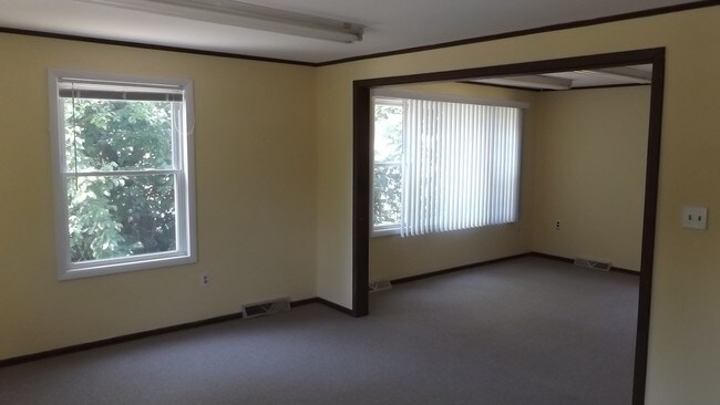
Property Detail
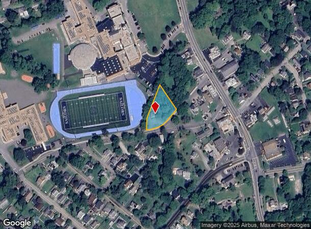
15 Trolley Rd
New York-Jersey City-White Plains, NY-NJ
13.08-006-005
2289-043-020-00005-000-0009
Westchester
Officebuilding
New York
X
9.000
36119C0018F
0.55 AC
2025
Northwest
2024
Westchester/So Connecticut
014703
DEMOGRAPHICS near 15 Trolley Rd
1 Mile
3 Mile
5 Mile
2024 Total Population
5,707
32,249
95,162
2029 Population
5,569
31,412
93,125
Pop Growth 2024-2029
(2.42%)
(2.60%)
(2.14%)
Average Age
44
43
42
2024 Total Households
1,962
12,135
33,552
HH Growth 2024-2029
(2.65%)
(2.88%)
(2.33%)
Median Household Inc
$127,394
$92,067
$99,548
Avg Household Size
2.70
2.50
2.70
2024 Avg HH Vehicles
2.00
2.00
2.00
Median Home Value
$413,351
$438,446
$423,462
Median Year Built
1958
1963
1964
Nearby Places
Map Layers
Map Styles
 Street
 Aerial
- Restaurants
- Banks
- Shops
- Fitness
- Groceries
PUBLIC TRANSPORTATION
TRANSIT/SUBWAY
Cortlandt Station (Hudson Line - Metro-North Commuter Railroad Company (Metro-North))
DRIVE
WALK
Distance
Cortlandt Station (Hudson Line - Metro-North Commuter Railroad Company (Metro-North))
4 min
20 min
1.0 mi
COMMUTER RAIL
Cortlandt Station (Hudson Line - Metro-North Commuter Railroad Company (Metro-North))
DRIVE
WALK
Distance
Cortlandt Station (Hudson Line - Metro-North Commuter Railroad Company (Metro-North))
4 min
20 min
1.0 mi
Peekskill Station (Hudson Line - Metro-North Commuter Railroad Company (Metro-North))
DRIVE
WALK
Distance
Peekskill Station (Hudson Line - Metro-North Commuter Railroad Company (Metro-North))
6 min
2.7 mi
AIRPORT
Westchester County
DRIVE
WALK
Distance
Westchester County
41 min
24.3 mi
New York Stewart International
DRIVE
WALK
Distance
New York Stewart International
47 min
26.6 mi
LaGuardia
DRIVE
WALK
Distance
LaGuardia
65 min
43.0 mi
Freight Ports
NY - Red Hook Container Terminal
DRIVE
WALK
Distance
NY - Red Hook Container Terminal
78 min
51.2 mi
SALE & LEASE HISTORY
LISTING DATE
SALE/LEASE

Sep 25, 2016
For Lease
Nearby Properties
Address
Land Use
TOTAL SIZE
Lot Size
Zoning
Address
Land Use
TOTAL SIZE
Lot Size
Zoning
Address
Land Use
TOTAL SIZE
Lot Size
Zoning
188.01 AC
Address
Land Use
TOTAL SIZE
Lot Size
Zoning
Address
Land Use
TOTAL SIZE
Lot Size
Zoning
157 AC
Address
Land Use
TOTAL SIZE
Lot Size
Zoning
2 AC
RR
Address
Land Use
TOTAL SIZE
Lot Size
Zoning
74.84 AC
Address
Land Use
TOTAL SIZE
Lot Size
Zoning
Address
Land Use
TOTAL SIZE
Lot Size
Zoning
4.80 AC
RW
Address
Land Use
TOTAL SIZE
Lot Size
Zoning
2.70 AC
Address
Land Use
TOTAL SIZE
Lot Size
Zoning
Address
Land Use
TOTAL SIZE
Lot Size
Zoning
8.93 AC
Address
Land Use
TOTAL SIZE
Lot Size
Zoning
2.99 AC
Address
Land Use
TOTAL SIZE
Lot Size
Zoning
Address
Land Use
TOTAL SIZE
Lot Size
Zoning
Address
Land Use
TOTAL SIZE
Lot Size
Zoning
Address
Land Use
TOTAL SIZE
Lot Size
Zoning
7.50 AC
Address
Land Use
TOTAL SIZE
Lot Size
Zoning
Address
Land Use
TOTAL SIZE
Lot Size
Zoning
410,221 SF
33.49 AC
LI
Address
Land Use
TOTAL SIZE
Lot Size
Zoning
23.27 AC
Address
Land Use
TOTAL SIZE
Lot Size
Zoning
48.07 AC
Address
Land Use
TOTAL SIZE
Lot Size
Zoning
26.80 AC
Address
Land Use
TOTAL SIZE
Lot Size
Zoning
655.36 AC
Address
Land Use
TOTAL SIZE
Lot Size
Zoning
8.75 AC
Address
Land Use
TOTAL SIZE
Lot Size
Zoning
0.39 AC
Address
Land Use
TOTAL SIZE
Lot Size
Zoning
0.21 AC
Address
Land Use
TOTAL SIZE
Lot Size
Zoning
13.75 AC
Address
Land Use
TOTAL SIZE
Lot Size
Zoning
0.10 AC
Address
Land Use
TOTAL SIZE
Lot Size
Zoning
Address
Land Use
TOTAL SIZE
Lot Size
Zoning
98,814 SF
0.93 AC
C-2
Address
Land Use
TOTAL SIZE
Lot Size
Zoning
143.43 AC
The World's #1 Commercial Real Estate Marketplace
Connect with us
© 2025 CoStar Group
The information above has been obtained from sources believed reliable. While we do not doubt its accuracy we have not verified it and make no guarantee, warranty or representation about it. It is your responsibility to independently confirm its accuracy and completeness. Any projections, opinions, assumptions, or estimates used are for example only and do not represent the current or future performance of the property. The value of this transaction to you depends on tax and other factors which should be evaluated by your tax, financial, and legal advisors. You and your advisors should conduct a careful, independent investigation of the property to determine to your satisfaction the suitability of the property for your needs.