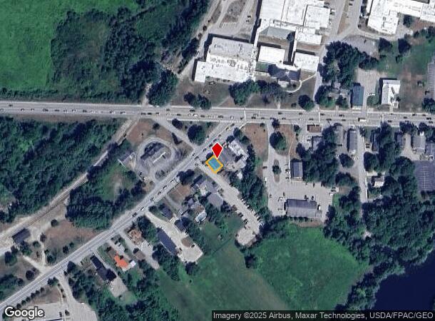
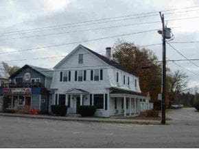
Property Record
15 W Main St, Conway, NH 03818

NEARBY LISTINGS FOR SALE OR LEASE
Property Detail
15 W Main St
Officebuilding
Carroll
X
New Hampshire
33003C0335D
0.04 AC
2024
Concord/New Hampshire North Area
2024
Other Market Areas
955401
CNWY-000277-000000-000129
DEMOGRAPHICS near 15 W Main St
1 Mile
3 Mile
5 Mile
2024 Total Population
1,653
5,051
8,896
2029 Population
1,754
5,440
9,588
Pop Growth 2024-2029
+ 6.11%
+ 7.70%
+ 7.78%
Average Age
45
47
47
2024 Total Households
739
2,297
4,047
HH Growth 2024-2029
+ 5.68%
+ 7.31%
+ 7.46%
Median Household Inc
$61,271
$60,328
$58,874
Avg Household Size
2.10
2.10
2.10
2024 Avg HH Vehicles
2.00
2.00
2.00
Median Home Value
$226,687
$253,448
$264,078
Median Year Built
1978
1981
1980
Nearby Places
Map Layers
Map Styles
 Street
 Aerial
- Restaurants
- Banks
- Shops
- Fitness
- Groceries
Nearby Properties
Address
Land Use
TOTAL SIZE
Lot Size
Zoning
Address
Land Use
TOTAL SIZE
Lot Size
Zoning
31.40 AC
HC
Address
Land Use
TOTAL SIZE
Lot Size
Zoning
64.60 AC
RA
Address
Land Use
TOTAL SIZE
Lot Size
Zoning
18.25 AC
HC
Address
Land Use
TOTAL SIZE
Lot Size
Zoning
190 AC
HC
Address
Land Use
TOTAL SIZE
Lot Size
Zoning
36 AC
VC
Address
Land Use
TOTAL SIZE
Lot Size
Zoning
8.06 AC
HC
Address
Land Use
TOTAL SIZE
Lot Size
Zoning
2.54 AC
HC
Address
Land Use
TOTAL SIZE
Lot Size
Zoning
3.60 AC
RR
Address
Land Use
TOTAL SIZE
Lot Size
Zoning
73.70 AC
RA
Address
Land Use
TOTAL SIZE
Lot Size
Zoning
6.53 AC
HC
Address
Land Use
TOTAL SIZE
Lot Size
Zoning
0.50 AC
HC
Address
Land Use
TOTAL SIZE
Lot Size
Zoning
18.96 AC
HC
Address
Land Use
TOTAL SIZE
Lot Size
Zoning
8.46 AC
HC
Address
Land Use
TOTAL SIZE
Lot Size
Zoning
4.44 AC
HC
Address
Land Use
TOTAL SIZE
Lot Size
Zoning
6.47 AC
HC
Address
Land Use
TOTAL SIZE
Lot Size
Zoning
4.55 AC
HC
Address
Land Use
TOTAL SIZE
Lot Size
Zoning
44.59 AC
HC
Address
Land Use
TOTAL SIZE
Lot Size
Zoning
2.99 AC
HC
Address
Land Use
TOTAL SIZE
Lot Size
Zoning
3.95 AC
RA
Address
Land Use
TOTAL SIZE
Lot Size
Zoning
9.97 AC
HC
Address
Land Use
TOTAL SIZE
Lot Size
Zoning
Address
Land Use
TOTAL SIZE
Lot Size
Zoning
1.94 AC
HC
Address
Land Use
TOTAL SIZE
Lot Size
Zoning
2.72 AC
HC
Address
Land Use
TOTAL SIZE
Lot Size
Zoning
1.70 AC
VC
Address
Land Use
TOTAL SIZE
Lot Size
Zoning
2.50 AC
VC
Address
Land Use
TOTAL SIZE
Lot Size
Zoning
5.32 AC
VC
Address
Land Use
TOTAL SIZE
Lot Size
Zoning
4.10 AC
HC
Address
Land Use
TOTAL SIZE
Lot Size
Zoning
1.61 AC
HC
Address
Land Use
TOTAL SIZE
Lot Size
Zoning
2.41 AC
HC
Address
Land Use
TOTAL SIZE
Lot Size
Zoning
10.36 AC
HC
The World's #1 Commercial Real Estate Marketplace
Connect with us
© 2025 CoStar Group
The information above has been obtained from sources believed reliable. While we do not doubt its accuracy we have not verified it and make no guarantee, warranty or representation about it. It is your responsibility to independently confirm its accuracy and completeness. Any projections, opinions, assumptions, or estimates used are for example only and do not represent the current or future performance of the property. The value of this transaction to you depends on tax and other factors which should be evaluated by your tax, financial, and legal advisors. You and your advisors should conduct a careful, independent investigation of the property to determine to your satisfaction the suitability of the property for your needs.