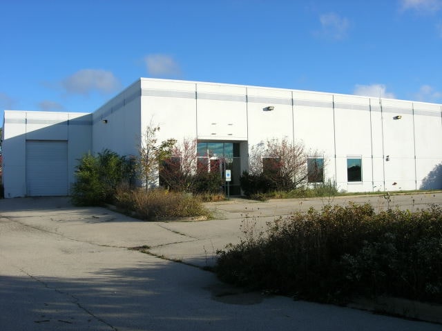
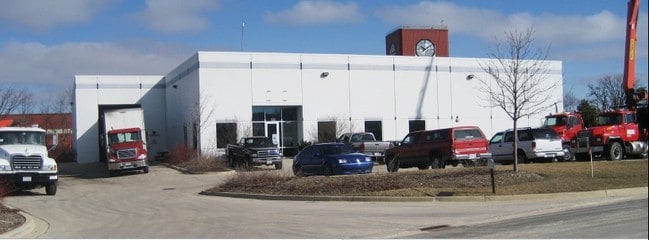
Property Record
150 Arrowhead Dr, Hampshire, IL 60140


Property Detail
150 Arrowhead Dr
01-02-152-004
LT # 9 OF ARROWHEAD BUSINESS PARK
Industrialgeneral
Kane
B1 DISTRIC
Illinois
B and X Area of moderate flood hazard, usually the area between the limits of the 100-year and 500-year floods.
9
2024
1.30 AC
2024
North Kane/I-90
850706
Chicago
15,000 SF
Chicago-Naperville-Elgin, IL-IN
NEARBY LISTINGS FOR SALE OR LEASE
DEMOGRAPHICS near 150 Arrowhead Dr
1 mile
3 mile
5 mile
2025 Total Population
542
10,370
31,004
2030 Population
568
10,635
32,040
Pop Growth 2025-2030
+ 4.80%
+ 2.56%
+ 3.34%
Average Age
48
59
49
2025 Total Households
213
5,072
13,186
HH Growth 2025-2030
+ 5.16%
+ 2.25%
+ 3.09%
Median Household Inc
$129,605
$79,489
$87,608
Avg Household Size
2.50
2.00
2.30
2025 Avg HH Vehicles
2.00
2.00
2.00
Median Home Value
$401,370
$339,934
$341,923
Median Year Built
2002
2004
2003
Nearby Places
Map Layers
Map Styles
 Street
 Aerial
Layers
 Traffic
 Biking
Places
Listings with unknown addresses are not visible on the map
- Restaurants
- Banks
- Shops
- Fitness
- Groceries
PUBLIC TRANSPORTATION
AIRPORT
Chicago/Rockford International
Drive
Walk
Distance
Chicago/Rockford International
49 min
37.3 mi
Chicago O'Hare International
Drive
Walk
Distance
Chicago O'Hare International
65 min
40.8 mi
Nearby Properties
Address
Land Use
TOTAL SIZE
Lot Size
Zoning
Address
Land Use
TOTAL SIZE
Lot Size
Zoning
8.48 AC
Address
Land Use
TOTAL SIZE
Lot Size
Zoning
Address
Land Use
TOTAL SIZE
Lot Size
Zoning
33.27 AC
Address
Land Use
TOTAL SIZE
Lot Size
Zoning
193,200 SF
23.60 AC
M2 MANUFAC
Address
Land Use
TOTAL SIZE
Lot Size
Zoning
13.24 AC
Address
Land Use
TOTAL SIZE
Lot Size
Zoning
76,458 SF
6.67 AC
M2 MANUFAC
Address
Land Use
TOTAL SIZE
Lot Size
Zoning
Address
Land Use
TOTAL SIZE
Lot Size
Zoning
105,030 SF
10.53 AC
O-M OFFICE
Address
Land Use
TOTAL SIZE
Lot Size
Zoning
141,588 SF
6.88 AC
Address
Land Use
TOTAL SIZE
Lot Size
Zoning
41,122 SF
4.25 AC
Address
Land Use
TOTAL SIZE
Lot Size
Zoning
5.50 AC
O-M OFFICE
Address
Land Use
TOTAL SIZE
Lot Size
Zoning
4.64 AC
Address
Land Use
TOTAL SIZE
Lot Size
Zoning
Address
Land Use
TOTAL SIZE
Lot Size
Zoning
19,328 SF
15.27 AC
B1 DISTRIC
Address
Land Use
TOTAL SIZE
Lot Size
Zoning
2.80 AC
Address
Land Use
TOTAL SIZE
Lot Size
Zoning
6,244 SF
3.21 AC
B1 DISTRIC
Address
Land Use
TOTAL SIZE
Lot Size
Zoning
0.50 AC
Address
Land Use
TOTAL SIZE
Lot Size
Zoning
Address
Land Use
TOTAL SIZE
Lot Size
Zoning
4.28 AC
Address
Land Use
TOTAL SIZE
Lot Size
Zoning
21,206 SF
1.73 AC
B1 DISTRIC
Address
Land Use
TOTAL SIZE
Lot Size
Zoning
4.13 AC
O-M OFFICE
Address
Land Use
TOTAL SIZE
Lot Size
Zoning
2.60 AC
B1 DISTRIC
Address
Land Use
TOTAL SIZE
Lot Size
Zoning
3,580 SF
1.10 AC
B1 DISTRIC
Address
Land Use
TOTAL SIZE
Lot Size
Zoning
7.49 AC
B1 DISTRIC
Address
Land Use
TOTAL SIZE
Lot Size
Zoning
2,681 SF
1.19 AC
B1 DISTRIC
Address
Land Use
TOTAL SIZE
Lot Size
Zoning
4,000 SF
5.50 AC
B1 DISTRIC
Address
Land Use
TOTAL SIZE
Lot Size
Zoning
0.50 AC
Address
Land Use
TOTAL SIZE
Lot Size
Zoning
7,680 SF
1.94 AC
Address
Land Use
TOTAL SIZE
Lot Size
Zoning
11,520 SF
1.80 AC
B1 DISTRIC
The World's #1 Commercial Real Estate Marketplace
Connect with us
© 2026 CoStar Group
The information above has been obtained from sources believed reliable. While we do not doubt its accuracy we have not verified it and make no guarantee, warranty or representation about it. It is your responsibility to independently confirm its accuracy and completeness. Any projections, opinions, assumptions, or estimates used are for example only and do not represent the current or future performance of the property. The value of this transaction to you depends on tax and other factors which should be evaluated by your tax, financial, and legal advisors. You and your advisors should conduct a careful, independent investigation of the property to determine to your satisfaction the suitability of the property for your needs.