Property Record
150 Avenue E, Rochelle, IL 61068
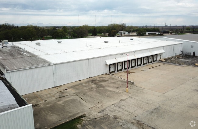
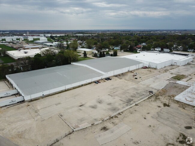
Property Detail
150 Avenue E
Rochelle, IL
RNG/BLK: TWP:0 SECT/LOT: S1/2 LOT 2 LOT 3 LOT 4 & S1/2 LOT 5 BLK 10 98-14505 BRAIDENS 4TH ADD CITY OF ROCHELLE
24-25-212-003
Ogle
Industrialacreage
Illinois
B and X Area of moderate flood hazard, usually the area between the limits of the 100-year and 500-year floods.
2-5
2024
0.64 AC
2024
I-39 Corr/Ogle Cnty
961600
Chicago
NEARBY LISTINGS FOR SALE OR LEASE
DEMOGRAPHICS near 150 Avenue E
1 mile
3 mile
5 mile
2025 Total Population
5,536
10,912
13,487
2030 Population
5,524
10,871
13,385
Pop Growth 2025-2030
(0.22%)
(0.38%)
(0.76%)
Average Age
38
39
39
2025 Total Households
2,204
4,331
5,278
HH Growth 2025-2030
(0.27%)
(0.39%)
(0.76%)
Median Household Inc
$61,457
$69,151
$71,148
Avg Household Size
2.40
2.40
2.50
2025 Avg HH Vehicles
2.00
2.00
2.00
Median Home Value
$156,935
$171,009
$175,648
Median Year Built
1968
1970
1970
Nearby Places
Map Layers
Map Styles
 Street
 Aerial
Transit
 Traffic
 Biking
Places
Listings with unknown addresses are not visible on the map
- Restaurants
- Banks
- Shops
- Fitness
- Groceries
PUBLIC TRANSPORTATION
AIRPORT
Chicago/Rockford International
Drive
Walk
Distance
Chicago/Rockford International
34 min
20.7 mi
Freight Ports
Port Milwaukee
Drive
Walk
Distance
Port Milwaukee
138 min
117.7 mi
SALE & LEASE HISTORY
LISTING DATE
SALE/LEASE

Sep 25, 2016
For Lease
Sep 15, 2017
For Lease
May 15, 2024
For Lease
Nearby Properties
Address
Land Use
TOTAL SIZE
Lot Size
Zoning
Address
Land Use
TOTAL SIZE
Lot Size
Zoning
24.14 AC
Address
Land Use
TOTAL SIZE
Lot Size
Zoning
39.59 AC
Address
Land Use
TOTAL SIZE
Lot Size
Zoning
45.20 AC
Address
Land Use
TOTAL SIZE
Lot Size
Zoning
47.91 AC
Address
Land Use
TOTAL SIZE
Lot Size
Zoning
26.63 AC
Address
Land Use
TOTAL SIZE
Lot Size
Zoning
20.21 AC
Address
Land Use
TOTAL SIZE
Lot Size
Zoning
28.48 AC
Address
Land Use
TOTAL SIZE
Lot Size
Zoning
22.16 AC
Address
Land Use
TOTAL SIZE
Lot Size
Zoning
18.14 AC
Address
Land Use
TOTAL SIZE
Lot Size
Zoning
14.66 AC
Address
Land Use
TOTAL SIZE
Lot Size
Zoning
14.33 AC
Address
Land Use
TOTAL SIZE
Lot Size
Zoning
Address
Land Use
TOTAL SIZE
Lot Size
Zoning
39,403 SF
13.64 AC
Address
Land Use
TOTAL SIZE
Lot Size
Zoning
34.90 AC
Address
Land Use
TOTAL SIZE
Lot Size
Zoning
Address
Land Use
TOTAL SIZE
Lot Size
Zoning
20,000 SF
12 AC
Address
Land Use
TOTAL SIZE
Lot Size
Zoning
14.13 AC
Address
Land Use
TOTAL SIZE
Lot Size
Zoning
25.19 AC
Address
Land Use
TOTAL SIZE
Lot Size
Zoning
55.67 AC
Address
Land Use
TOTAL SIZE
Lot Size
Zoning
20,200 SF
5.10 AC
Address
Land Use
TOTAL SIZE
Lot Size
Zoning
23.94 AC
Address
Land Use
TOTAL SIZE
Lot Size
Zoning
41.28 AC
Address
Land Use
TOTAL SIZE
Lot Size
Zoning
10,260 SF
17.06 AC
Address
Land Use
TOTAL SIZE
Lot Size
Zoning
9.55 AC
Address
Land Use
TOTAL SIZE
Lot Size
Zoning
176,200 SF
15.72 AC
Address
Land Use
TOTAL SIZE
Lot Size
Zoning
14.90 AC
Address
Land Use
TOTAL SIZE
Lot Size
Zoning
2.64 AC
Address
Land Use
TOTAL SIZE
Lot Size
Zoning
21,000 SF
4.81 AC
Address
Land Use
TOTAL SIZE
Lot Size
Zoning
55,200 SF
1.74 AC
The World's #1 Commercial Real Estate Marketplace
Connect with us
© 2026 CoStar Group
The information above has been obtained from sources believed reliable. While we do not doubt its accuracy we have not verified it and make no guarantee, warranty or representation about it. It is your responsibility to independently confirm its accuracy and completeness. Any projections, opinions, assumptions, or estimates used are for example only and do not represent the current or future performance of the property. The value of this transaction to you depends on tax and other factors which should be evaluated by your tax, financial, and legal advisors. You and your advisors should conduct a careful, independent investigation of the property to determine to your satisfaction the suitability of the property for your needs.