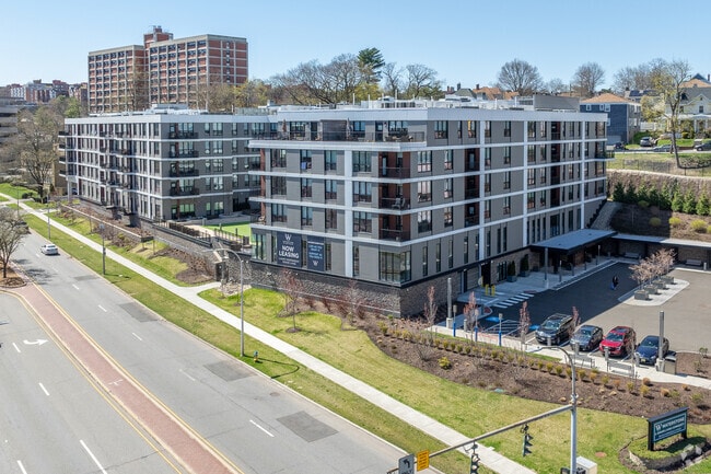
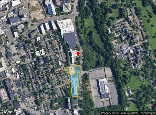
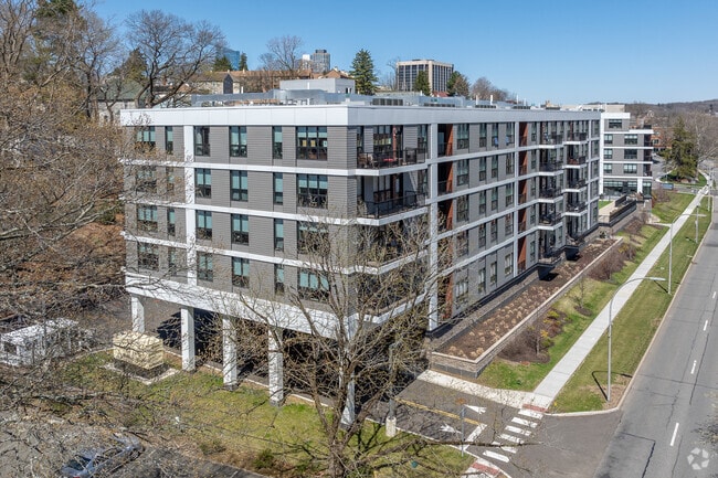
Property Record
150 Bloomingdale Rd, White Plains, NY 10605
NEARBY LISTINGS FOR SALE OR LEASE
Property Detail
150 Bloomingdale Rd
5517-000-0131-00021-003-0002-121-0000
Final Subdivision Plat Waterstone White
Medicalclinic
Westchester
X
New York
36119C0269F
2.121
2025
2.78 AC
2024
White Plains
009400
Westchester/So Connecticut
237,962 SF
New York-Jersey City-White Plains, NY-NJ
DEMOGRAPHICS near 150 Bloomingdale Rd
1 Mile
3 Mile
5 Mile
2024 Total Population
35,873
109,912
232,541
2029 Population
35,822
108,567
228,282
Pop Growth 2024-2029
(0.14%)
(1.22%)
(1.83%)
Average Age
42
42
42
2024 Total Households
16,253
42,596
85,059
HH Growth 2024-2029
(0.09%)
(1.20%)
(1.85%)
Median Household Inc
$99,314
$126,565
$141,969
Avg Household Size
2.10
2.40
2.60
2024 Avg HH Vehicles
1.00
2.00
2.00
Median Home Value
$495,050
$662,986
$741,417
Median Year Built
1966
1961
1959
Nearby Places
- Restaurants
- Banks
- Shops
- Fitness
- Groceries
PUBLIC TRANSPORTATION
COMMUTER RAIL
White Plains Station (Harlem Line - Metro-North Commuter Railroad Company (Metro-North))
DRIVE
WALK
Distance
White Plains Station (Harlem Line - Metro-North Commuter Railroad Company (Metro-North))
4 min
1.7 mi
North White Plains Station (Harlem Line - Metro-North Commuter Railroad Company (Metro-North))
DRIVE
WALK
Distance
North White Plains Station (Harlem Line - Metro-North Commuter Railroad Company (Metro-North))
4 min
2.2 mi
AIRPORT
Westchester County
DRIVE
WALK
Distance
Westchester County
12 min
7.6 mi
LaGuardia
DRIVE
WALK
Distance
LaGuardia
40 min
23.2 mi
John F Kennedy International
DRIVE
WALK
Distance
John F Kennedy International
46 min
30.7 mi
Freight Ports
NY - Red Hook Container Terminal
DRIVE
WALK
Distance
NY - Red Hook Container Terminal
55 min
33.7 mi
Nearby Properties
Address
Land Use
TOTAL SIZE
Lot Size
Zoning
Address
Land Use
TOTAL SIZE
Lot Size
Zoning
Address
Land Use
TOTAL SIZE
Lot Size
Zoning
381,836 SF
16.68 AC
A3
Address
Land Use
TOTAL SIZE
Lot Size
Zoning
75.87 AC
R-20
Address
Land Use
TOTAL SIZE
Lot Size
Zoning
237,313 SF
22.67 AC
A1
Address
Land Use
TOTAL SIZE
Lot Size
Zoning
16.22 AC
UR
Address
Land Use
TOTAL SIZE
Lot Size
Zoning
22.44 AC
R-20
Address
Land Use
TOTAL SIZE
Lot Size
Zoning
7.98 AC
CA
Address
Land Use
TOTAL SIZE
Lot Size
Zoning
1,975 SF
13.80 AC
CA
Address
Land Use
TOTAL SIZE
Lot Size
Zoning
29.42 AC
PUD
Address
Land Use
TOTAL SIZE
Lot Size
Zoning
10.90 AC
UR
Address
Land Use
TOTAL SIZE
Lot Size
Zoning
3.16 AC
Address
Land Use
TOTAL SIZE
Lot Size
Zoning
5.57 AC
AA1
Address
Land Use
TOTAL SIZE
Lot Size
Zoning
64.41 AC
R-20
Address
Land Use
TOTAL SIZE
Lot Size
Zoning
48,499 SF
8.52 AC
A2/A3
Address
Land Use
TOTAL SIZE
Lot Size
Zoning
1,200 SF
21.21 AC
R-20
Address
Land Use
TOTAL SIZE
Lot Size
Zoning
7.98 AC
M-14
Address
Land Use
TOTAL SIZE
Lot Size
Zoning
48,267 SF
11.04 AC
A2 A
Address
Land Use
TOTAL SIZE
Lot Size
Zoning
11.21 AC
R-20
Address
Land Use
TOTAL SIZE
Lot Size
Zoning
5.43 AC
R-40
Address
Land Use
TOTAL SIZE
Lot Size
Zoning
320 SF
5.38 AC
LI
Address
Land Use
TOTAL SIZE
Lot Size
Zoning
1,348 SF
5.67 AC
CA
Address
Land Use
TOTAL SIZE
Lot Size
Zoning
6.09 AC
DS
Address
Land Use
TOTAL SIZE
Lot Size
Zoning
1,630 SF
2.64 AC
LOB
Address
Land Use
TOTAL SIZE
Lot Size
Zoning
2,100 SF
24.12 AC
A3
Address
Land Use
TOTAL SIZE
Lot Size
Zoning
121.29 AC
Address
Land Use
TOTAL SIZE
Lot Size
Zoning
68,616 SF
3.11 AC
Address
Land Use
TOTAL SIZE
Lot Size
Zoning
2.26 AC
CA
Address
Land Use
TOTAL SIZE
Lot Size
Zoning
8.05 AC
R-10
Address
Land Use
TOTAL SIZE
Lot Size
Zoning
5.37 AC
R-20
Address
Land Use
TOTAL SIZE
Lot Size
Zoning
3.46 AC
CA
The World's #1 Commercial Real Estate Marketplace
Connect with us
© 2025 CoStar Group
The information above has been obtained from sources believed reliable. While we do not doubt its accuracy we have not verified it and make no guarantee, warranty or representation about it. It is your responsibility to independently confirm its accuracy and completeness. Any projections, opinions, assumptions, or estimates used are for example only and do not represent the current or future performance of the property. The value of this transaction to you depends on tax and other factors which should be evaluated by your tax, financial, and legal advisors. You and your advisors should conduct a careful, independent investigation of the property to determine to your satisfaction the suitability of the property for your needs.