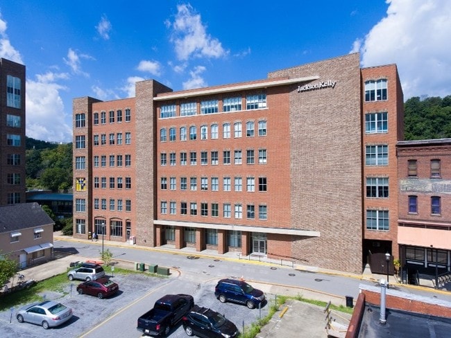
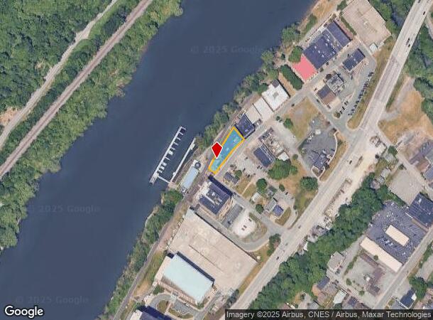
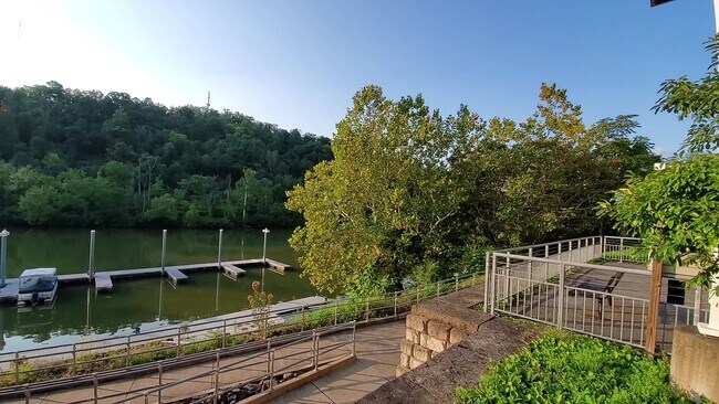
Property Record
150 Clay St, Morgantown, WV 26501
Current Lease Availabilities
NEARBY LISTINGS FOR SALE OR LEASE
Property Detail
150 Clay St
Morgantown, WV
Dr Jos A Mcclanes Heirs Plan Of Lots
09-28-00190000
LOT 8 170 CLAY ST
Skyscraperhighrisecommercialoffices
Monongalia
X
West Virginia
54061C0114F
8,170
2025
0.20 AC
2025
West Virginia North Area
011000
Other Market Areas
DEMOGRAPHICS near 150 Clay St
1 Mile
3 Mile
5 Mile
2024 Total Population
15,140
57,887
80,509
2029 Population
15,595
59,467
82,571
Pop Growth 2024-2029
+ 3.01%
+ 2.73%
+ 2.56%
Average Age
34
34
35
2024 Total Households
6,141
25,028
34,402
HH Growth 2024-2029
+ 3.16%
+ 2.83%
+ 2.65%
Median Household Inc
$34,734
$41,009
$51,486
Avg Household Size
2.00
2.00
2.10
2024 Avg HH Vehicles
1.00
2.00
2.00
Median Home Value
$196,829
$221,037
$231,937
Median Year Built
1952
1979
1984
Nearby Places
Map Layers
Map Styles
 Street
 Aerial
- Restaurants
- Banks
- Shops
- Fitness
- Groceries
PUBLIC TRANSPORTATION
TRANSIT/SUBWAY
Walnut (BEE-WAL-BEE - West Virginia University Personal Rapid Transit, ENG-WAL-ENG - West Virginia University Personal Rapid Transit, HSC-WAL-HSC - West Virginia University Personal Rapid Transit, WAL-ENG-WAL - West Virginia University Personal Rapid Transit, WAL-HSC-WAL - West Virginia University Personal Rapid Transit)
DRIVE
WALK
Distance
Walnut (BEE-WAL-BEE - West Virginia University Personal Rapid Transit, ENG-WAL-ENG - West Virginia University Personal Rapid Transit, HSC-WAL-HSC - West Virginia University Personal Rapid Transit, WAL-ENG-WAL - West Virginia University Personal Rapid Transit, WAL-HSC-WAL - West Virginia University Personal Rapid Transit)
1 min
10 min
0.5 mi
Beechurst (BEE-HSC-BEE - West Virginia University Personal Rapid Transit, BEE-TOW-BEE - West Virginia University Personal Rapid Transit, BEE-WAL-BEE - West Virginia University Personal Rapid Transit, ENG-BEE-ENG - West Virginia University Personal Rapid Transit, WAL-BEE-WAL - West Virginia University Personal Rapid Transit)
DRIVE
WALK
Distance
Beechurst (BEE-HSC-BEE - West Virginia University Personal Rapid Transit, BEE-TOW-BEE - West Virginia University Personal Rapid Transit, BEE-WAL-BEE - West Virginia University Personal Rapid Transit, ENG-BEE-ENG - West Virginia University Personal Rapid Transit, WAL-BEE-WAL - West Virginia University Personal Rapid Transit)
1 min
19 min
0.8 mi
AIRPORT
North Central West Virginia
DRIVE
WALK
Distance
North Central West Virginia
39 min
32.1 mi
Freight Ports
Port of Baltimore
DRIVE
WALK
Distance
Port of Baltimore
240 min
212.0 mi
Nearby Properties
Address
Land Use
TOTAL SIZE
Lot Size
Zoning
Address
Land Use
TOTAL SIZE
Lot Size
Zoning
23.86 AC
Address
Land Use
TOTAL SIZE
Lot Size
Zoning
5.15 AC
Address
Land Use
TOTAL SIZE
Lot Size
Zoning
14.68 AC
Address
Land Use
TOTAL SIZE
Lot Size
Zoning
137.68 AC
Address
Land Use
TOTAL SIZE
Lot Size
Zoning
75.75 AC
Address
Land Use
TOTAL SIZE
Lot Size
Zoning
31.67 AC
Address
Land Use
TOTAL SIZE
Lot Size
Zoning
109.09 AC
Address
Land Use
TOTAL SIZE
Lot Size
Zoning
3.07 AC
Address
Land Use
TOTAL SIZE
Lot Size
Zoning
35.17 AC
Address
Land Use
TOTAL SIZE
Lot Size
Zoning
19.34 AC
Address
Land Use
TOTAL SIZE
Lot Size
Zoning
7.10 AC
Address
Land Use
TOTAL SIZE
Lot Size
Zoning
15.71 AC
Address
Land Use
TOTAL SIZE
Lot Size
Zoning
30.77 AC
Address
Land Use
TOTAL SIZE
Lot Size
Zoning
53.50 AC
Address
Land Use
TOTAL SIZE
Lot Size
Zoning
Address
Land Use
TOTAL SIZE
Lot Size
Zoning
Address
Land Use
TOTAL SIZE
Lot Size
Zoning
9.63 AC
Address
Land Use
TOTAL SIZE
Lot Size
Zoning
34.21 AC
Address
Land Use
TOTAL SIZE
Lot Size
Zoning
154.89 AC
Address
Land Use
TOTAL SIZE
Lot Size
Zoning
0.23 AC
Address
Land Use
TOTAL SIZE
Lot Size
Zoning
21.61 AC
Address
Land Use
TOTAL SIZE
Lot Size
Zoning
Address
Land Use
TOTAL SIZE
Lot Size
Zoning
22.71 AC
Address
Land Use
TOTAL SIZE
Lot Size
Zoning
Address
Land Use
TOTAL SIZE
Lot Size
Zoning
75.11 AC
Address
Land Use
TOTAL SIZE
Lot Size
Zoning
Address
Land Use
TOTAL SIZE
Lot Size
Zoning
9.94 AC
Address
Land Use
TOTAL SIZE
Lot Size
Zoning
18.03 AC
Address
Land Use
TOTAL SIZE
Lot Size
Zoning
0.11 AC
Address
Land Use
TOTAL SIZE
Lot Size
Zoning
The World's #1 Commercial Real Estate Marketplace
Connect with us
© 2026 CoStar Group
The information above has been obtained from sources believed reliable. While we do not doubt its accuracy we have not verified it and make no guarantee, warranty or representation about it. It is your responsibility to independently confirm its accuracy and completeness. Any projections, opinions, assumptions, or estimates used are for example only and do not represent the current or future performance of the property. The value of this transaction to you depends on tax and other factors which should be evaluated by your tax, financial, and legal advisors. You and your advisors should conduct a careful, independent investigation of the property to determine to your satisfaction the suitability of the property for your needs.