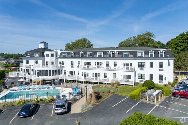
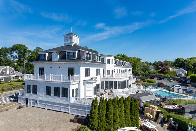
Property Record
150 Conanicus Ave, Jamestown, RI 02835

Property Detail
150 Conanicus Ave
JAME-000008-000000-000258-C000001
Newport
Commercialcondominium
Rhode Island
AE The base floodplain where base flood elevations are provided. AE Zones are now used on new format FIRMs instead of A1-A30 Zones.
258-c1
2025
Newport County
2025
Providence
041300
Providence-Warwick, RI-MA
5,680 SF
NEARBY LISTINGS FOR SALE OR LEASE
DEMOGRAPHICS near 150 Conanicus Ave
1 mile
3 mile
5 mile
2025 Total Population
1,984
17,336
55,159
2030 Population
1,956
17,202
54,708
Pop Growth 2025-2030
(1.41%)
(0.77%)
(0.82%)
Average Age
53
44
44
2025 Total Households
943
7,560
23,658
HH Growth 2025-2030
(0.64%)
(0.05%)
(1.70%)
Median Household Inc
$124,431
$77,391
$100,964
Avg Household Size
2.10
2.10
2.20
2025 Avg HH Vehicles
2.00
1.00
2.00
Median Home Value
$948,302
$840,884
$727,080
Median Year Built
1959
1957
1964
Nearby Places
Map Layers
Map Styles
 Street
 Aerial
Layers
 Traffic
 Biking
Places
Listings with unknown addresses are not visible on the map
- Restaurants
- Banks
- Shops
- Fitness
- Groceries
PUBLIC TRANSPORTATION
AIRPORT
Rhode Island Tf Green International
Drive
Walk
Distance
Rhode Island Tf Green International
40 min
24.9 mi
Freight Ports
Port of Davisville, RI
Drive
Walk
Distance
Port of Davisville, RI
26 min
13.8 mi
SALE & LEASE HISTORY
LISTING DATE
SALE/LEASE

Jan 23, 2020
For Sale
Feb 24, 2021
For Sale
Nearby Properties
Address
Land Use
TOTAL SIZE
Lot Size
Zoning
Address
Land Use
TOTAL SIZE
Lot Size
Zoning
264,032 SF
3.73 AC
GB
Address
Land Use
TOTAL SIZE
Lot Size
Zoning
237,976 SF
8.99 AC
WB
Address
Land Use
TOTAL SIZE
Lot Size
Zoning
143,311 SF
2.94 AC
GB
Address
Land Use
TOTAL SIZE
Lot Size
Zoning
249,902 SF
27.88 AC
UV
Address
Land Use
TOTAL SIZE
Lot Size
Zoning
76,534 SF
5.29 AC
WB
Address
Land Use
TOTAL SIZE
Lot Size
Zoning
86,091 SF
6.50 AC
CI
Address
Land Use
TOTAL SIZE
Lot Size
Zoning
158,333 SF
1.81 AC
R10
Address
Land Use
TOTAL SIZE
Lot Size
Zoning
217,212 SF
10.46 AC
R10
Address
Land Use
TOTAL SIZE
Lot Size
Zoning
172,320 SF
10.14 AC
R10
Address
Land Use
TOTAL SIZE
Lot Size
Zoning
21,977 SF
36.71 AC
R120
Address
Land Use
TOTAL SIZE
Lot Size
Zoning
21.21 AC
RR20
Address
Land Use
TOTAL SIZE
Lot Size
Zoning
41,145 SF
9.33 AC
R120
Address
Land Use
TOTAL SIZE
Lot Size
Zoning
36,984 SF
10 AC
R10
Address
Land Use
TOTAL SIZE
Lot Size
Zoning
50,220 SF
8.83 AC
TM
Address
Land Use
TOTAL SIZE
Lot Size
Zoning
24 AC
R120
Address
Land Use
TOTAL SIZE
Lot Size
Zoning
45,283 SF
1.66 AC
WB
Address
Land Use
TOTAL SIZE
Lot Size
Zoning
77.46 AC
R80
Address
Land Use
TOTAL SIZE
Lot Size
Zoning
121,259 SF
6.40 AC
GB
Address
Land Use
TOTAL SIZE
Lot Size
Zoning
56,313 SF
0.53 AC
GB
Address
Land Use
TOTAL SIZE
Lot Size
Zoning
87,092 SF
1.46 AC
WB
Address
Land Use
TOTAL SIZE
Lot Size
Zoning
51,686 SF
2.46 AC
WB
Address
Land Use
TOTAL SIZE
Lot Size
Zoning
100,503 SF
2.87 AC
UV
Address
Land Use
TOTAL SIZE
Lot Size
Zoning
32,896 SF
0.55 AC
GB
Address
Land Use
TOTAL SIZE
Lot Size
Zoning
9,744 SF
15 AC
R120
Address
Land Use
TOTAL SIZE
Lot Size
Zoning
40,857 SF
0.77 AC
R3
Address
Land Use
TOTAL SIZE
Lot Size
Zoning
44,396 SF
0.80 AC
GB
Address
Land Use
TOTAL SIZE
Lot Size
Zoning
52.56 AC
R120
Address
Land Use
TOTAL SIZE
Lot Size
Zoning
7,664 SF
1 AC
R10
Address
Land Use
TOTAL SIZE
Lot Size
Zoning
1,929 SF
2.70 AC
R80
Address
Land Use
TOTAL SIZE
Lot Size
Zoning
98,425 SF
0.64 AC
R10
The World's #1 Commercial Real Estate Marketplace
Connect with us
© 2026 CoStar Group
The information above has been obtained from sources believed reliable. While we do not doubt its accuracy we have not verified it and make no guarantee, warranty or representation about it. It is your responsibility to independently confirm its accuracy and completeness. Any projections, opinions, assumptions, or estimates used are for example only and do not represent the current or future performance of the property. The value of this transaction to you depends on tax and other factors which should be evaluated by your tax, financial, and legal advisors. You and your advisors should conduct a careful, independent investigation of the property to determine to your satisfaction the suitability of the property for your needs.