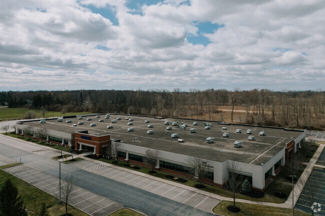
Property Record
150 Crosspoint Pkwy, Getzville, NY 14068


Current Lease Availabilities
NEARBY LISTINGS FOR SALE OR LEASE
Property Detail
150 Crosspoint Pkwy
142289 28.00-1-68.12
Holland Land Companys Survey
Officebuilding
Erie
AE
New York
36029C0067H
68.120
2025
10.30 AC
2024
North
009009
Buffalo/Niagara Falls
86,640 SF
Buffalo-Cheektowaga-Niagara Falls, NY
DEMOGRAPHICS near 150 Crosspoint Pkwy
1 Mile
3 Mile
5 Mile
2024 Total Population
4,983
44,309
131,786
2029 Population
4,883
44,189
131,690
Pop Growth 2024-2029
(2.01%)
(0.27%)
(0.07%)
Average Age
41
43
42
2024 Total Households
1,952
17,599
51,917
HH Growth 2024-2029
(2.15%)
(0.15%)
(0.01%)
Median Household Inc
$132,959
$99,511
$84,650
Avg Household Size
2.50
2.40
2.30
2024 Avg HH Vehicles
2.00
2.00
2.00
Median Home Value
$374,390
$305,960
$274,220
Median Year Built
1988
1982
1977
Nearby Places
Map Layers
Map Styles
 Street
 Aerial
- Restaurants
- Banks
- Shops
- Fitness
- Groceries
PUBLIC TRANSPORTATION
AIRPORT
Buffalo Niagara International
DRIVE
WALK
Distance
Buffalo Niagara International
19 min
7.4 mi
Niagara Falls International
DRIVE
WALK
Distance
Niagara Falls International
23 min
12.2 mi
Nearby Properties
Address
Land Use
TOTAL SIZE
Lot Size
Zoning
Address
Land Use
TOTAL SIZE
Lot Size
Zoning
283,706 SF
68.90 AC
Address
Land Use
TOTAL SIZE
Lot Size
Zoning
41,104 SF
27.52 AC
Address
Land Use
TOTAL SIZE
Lot Size
Zoning
2,592 SF
22.75 AC
NCD
Address
Land Use
TOTAL SIZE
Lot Size
Zoning
5,364 SF
56.45 AC
Address
Land Use
TOTAL SIZE
Lot Size
Zoning
7,080 SF
21.40 AC
MFR-5
Address
Land Use
TOTAL SIZE
Lot Size
Zoning
113,096 SF
9 AC
Address
Land Use
TOTAL SIZE
Lot Size
Zoning
213,943 SF
5.50 AC
Address
Land Use
TOTAL SIZE
Lot Size
Zoning
403,248 SF
53.50 AC
Address
Land Use
TOTAL SIZE
Lot Size
Zoning
83,256 SF
8.01 AC
NCD
Address
Land Use
TOTAL SIZE
Lot Size
Zoning
253,920 SF
22.83 AC
RD
Address
Land Use
TOTAL SIZE
Lot Size
Zoning
6,384 SF
13.40 AC
Address
Land Use
TOTAL SIZE
Lot Size
Zoning
154,296 SF
7.90 AC
RD
Address
Land Use
TOTAL SIZE
Lot Size
Zoning
28,530 SF
30.20 AC
NCD
Address
Land Use
TOTAL SIZE
Lot Size
Zoning
286,288 SF
50.90 AC
Address
Land Use
TOTAL SIZE
Lot Size
Zoning
12,132 SF
12.30 AC
Address
Land Use
TOTAL SIZE
Lot Size
Zoning
110,243 SF
19.06 AC
Address
Land Use
TOTAL SIZE
Lot Size
Zoning
87,718 SF
1.26 AC
RD
Address
Land Use
TOTAL SIZE
Lot Size
Zoning
49,478 SF
4 AC
NCD
Address
Land Use
TOTAL SIZE
Lot Size
Zoning
75,448 SF
8.82 AC
Address
Land Use
TOTAL SIZE
Lot Size
Zoning
93,390 SF
5.17 AC
Address
Land Use
TOTAL SIZE
Lot Size
Zoning
128,867 SF
9.42 AC
RD
Address
Land Use
TOTAL SIZE
Lot Size
Zoning
106,676 SF
8.90 AC
RD
Address
Land Use
TOTAL SIZE
Lot Size
Zoning
270,320 SF
12.20 AC
Address
Land Use
TOTAL SIZE
Lot Size
Zoning
136,200 SF
4.10 AC
Address
Land Use
TOTAL SIZE
Lot Size
Zoning
131,200 SF
16.90 AC
Address
Land Use
TOTAL SIZE
Lot Size
Zoning
39,454 SF
4.81 AC
GC
Address
Land Use
TOTAL SIZE
Lot Size
Zoning
131,128 SF
15.48 AC
RD
Address
Land Use
TOTAL SIZE
Lot Size
Zoning
81,920 SF
3.82 AC
Address
Land Use
TOTAL SIZE
Lot Size
Zoning
92,368 SF
0.75 AC
RD
Address
Land Use
TOTAL SIZE
Lot Size
Zoning
63,464 SF
2.44 AC
The World's #1 Commercial Real Estate Marketplace
Connect with us
© 2025 CoStar Group
The information above has been obtained from sources believed reliable. While we do not doubt its accuracy we have not verified it and make no guarantee, warranty or representation about it. It is your responsibility to independently confirm its accuracy and completeness. Any projections, opinions, assumptions, or estimates used are for example only and do not represent the current or future performance of the property. The value of this transaction to you depends on tax and other factors which should be evaluated by your tax, financial, and legal advisors. You and your advisors should conduct a careful, independent investigation of the property to determine to your satisfaction the suitability of the property for your needs.