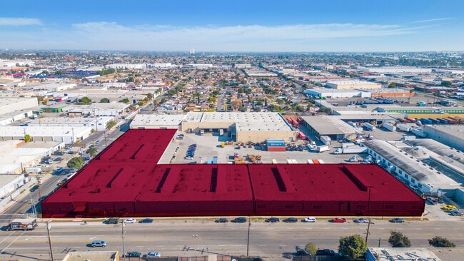
Property Record
15700 S Main St, Gardena, CA 90248
Current Lease Availabilities
Property Detail
15700 S Main St
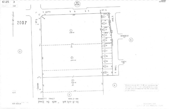
6125-003-001
BASSETT TRACT N 315 FT OF S 640 FT EX OF STS OF LOT 4
Warehouse
Los Angeles
LCM2*
California
B and X Area of moderate flood hazard, usually the area between the limits of the 100-year and 500-year floods.
4
2024
4.27 AC
2025
West Rancho Dominguez
541003
Los Angeles
201,500 SF
Los Angeles-Long Beach-Glendale, CA
NEARBY LISTINGS FOR SALE OR LEASE
DEMOGRAPHICS near 15700 S Main St
1 mile
3 mile
5 mile
2025 Total Population
12,989
206,887
730,265
2030 Population
12,860
204,469
720,444
Pop Growth 2025-2030
(0.99%)
(1.17%)
(1.34%)
Average Age
40
40
38
2025 Total Households
3,746
61,684
210,630
HH Growth 2025-2030
(1.25%)
(1.36%)
(1.52%)
Median Household Inc
$70,088
$82,979
$74,781
Avg Household Size
3.20
3.20
3.30
2025 Avg HH Vehicles
2.00
2.00
2.00
Median Home Value
$687,742
$706,093
$704,513
Median Year Built
1965
1959
1959
Nearby Places
Map Layers
Map Styles
 Street
 Aerial
Transit
 Traffic
 Biking
Places
Listings with unknown addresses are not visible on the map
- Restaurants
- Banks
- Shops
- Fitness
- Groceries
PUBLIC TRANSPORTATION
AIRPORT
Long Beach (Daugherty Field)
Drive
Walk
Distance
Long Beach (Daugherty Field)
16 min
10.7 mi
Los Angeles International
Drive
Walk
Distance
Los Angeles International
18 min
12.5 mi
Bob Hope
Drive
Walk
Distance
Bob Hope
38 min
29.5 mi
Freight Ports
Port of Long Beach
Drive
Walk
Distance
Port of Long Beach
19 min
12.6 mi
Nearby Properties
Address
Land Use
TOTAL SIZE
Lot Size
Zoning
Address
Land Use
TOTAL SIZE
Lot Size
Zoning
64,456 SF
11.71 AC
CASP-10*
Address
Land Use
TOTAL SIZE
Lot Size
Zoning
422,640 SF
LAM3
Address
Land Use
TOTAL SIZE
Lot Size
Zoning
248,531 SF
13.30 AC
LCM11/2-B1
Address
Land Use
TOTAL SIZE
Lot Size
Zoning
291,731 SF
16.84 AC
CAML*
Address
Land Use
TOTAL SIZE
Lot Size
Zoning
3,585,714 SF
67.35 AC
LAM3
Address
Land Use
TOTAL SIZE
Lot Size
Zoning
409,522 SF
11.41 AC
LAM3
Address
Land Use
TOTAL SIZE
Lot Size
Zoning
214,782 SF
3.66 AC
GAR3
Address
Land Use
TOTAL SIZE
Lot Size
Zoning
260,766 SF
10.70 AC
LAM3
Address
Land Use
TOTAL SIZE
Lot Size
Zoning
169,400 SF
8.11 AC
COMH*
Address
Land Use
TOTAL SIZE
Lot Size
Zoning
402,197 SF
27.29 AC
COMH*
Address
Land Use
TOTAL SIZE
Lot Size
Zoning
515,047 SF
4.87 AC
COMH*
Address
Land Use
TOTAL SIZE
Lot Size
Zoning
430,706 SF
18.95 AC
CASP-4*
Address
Land Use
TOTAL SIZE
Lot Size
Zoning
514,397 SF
24.34 AC
COMH-B*
Address
Land Use
TOTAL SIZE
Lot Size
Zoning
472,062 SF
24.39 AC
COMH-B*
Address
Land Use
TOTAL SIZE
Lot Size
Zoning
125,849 SF
6.08 AC
LAM2
Address
Land Use
TOTAL SIZE
Lot Size
Zoning
24,060 SF
LAM2
Address
Land Use
TOTAL SIZE
Lot Size
Zoning
546,606 SF
17.58 AC
LAM3
Address
Land Use
TOTAL SIZE
Lot Size
Zoning
230,694 SF
9.02 AC
COMH-B*
Address
Land Use
TOTAL SIZE
Lot Size
Zoning
499,562 SF
6.50 AC
LAM3
Address
Land Use
TOTAL SIZE
Lot Size
Zoning
210,742 SF
11.25 AC
CAML*
Address
Land Use
TOTAL SIZE
Lot Size
Zoning
536,092 SF
3.79 AC
LAM3
Address
Land Use
TOTAL SIZE
Lot Size
Zoning
533,879 SF
10.02 AC
LAM2
Address
Land Use
TOTAL SIZE
Lot Size
Zoning
157,320 SF
7.18 AC
COMH*
Address
Land Use
TOTAL SIZE
Lot Size
Zoning
519,144 SF
3.49 AC
LAM3
Address
Land Use
TOTAL SIZE
Lot Size
Zoning
71,479 SF
3.11 AC
CAML*
Address
Land Use
TOTAL SIZE
Lot Size
Zoning
118,191 SF
Address
Land Use
TOTAL SIZE
Lot Size
Zoning
146,182 SF
CAML*
Address
Land Use
TOTAL SIZE
Lot Size
Zoning
146,830 SF
7.26 AC
LAM3
Address
Land Use
TOTAL SIZE
Lot Size
Zoning
169,426 SF
3.50 AC
LCM11/2-B1
Address
Land Use
TOTAL SIZE
Lot Size
Zoning
65,998 SF
7.11 AC
LAM3
The World's #1 Commercial Real Estate Marketplace
Connect with us
© 2026 CoStar Group
The information above has been obtained from sources believed reliable. While we do not doubt its accuracy we have not verified it and make no guarantee, warranty or representation about it. It is your responsibility to independently confirm its accuracy and completeness. Any projections, opinions, assumptions, or estimates used are for example only and do not represent the current or future performance of the property. The value of this transaction to you depends on tax and other factors which should be evaluated by your tax, financial, and legal advisors. You and your advisors should conduct a careful, independent investigation of the property to determine to your satisfaction the suitability of the property for your needs.