Property Record
150 1St St N, Jacksonville, FL 32206
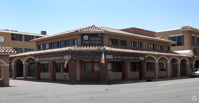

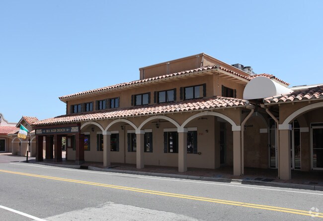

Property Detail
150 1St St N
Jacksonville, FL
3-28 33-2S-29E .568 PABLO BEACH NORTH LOTS 1,2 BLK 31, STRIP OF LAND LYING EAST THEREOF
174034-0000
Duval
Officebuilding
Florida
JCBD
1,2
2025
0.57 AC
2026
Beaches
014104
Jacksonville (Florida)
38,993 SF
NEARBY LISTINGS FOR SALE OR LEASE
DEMOGRAPHICS near 150 1St St N
1 mile
3 mile
5 mile
2025 Total Population
10,258
44,389
107,998
2030 Population
11,026
47,202
115,744
Pop Growth 2025-2030
+ 7.49%
+ 6.34%
+ 7.17%
Average Age
42
43
43
2025 Total Households
5,282
20,864
48,206
HH Growth 2025-2030
+ 7.91%
+ 6.84%
+ 7.48%
Median Household Inc
$117,767
$110,922
$102,340
Avg Household Size
1.90
2.10
2.20
2025 Avg HH Vehicles
2.00
2.00
2.00
Median Home Value
$630,384
$637,637
$555,606
Median Year Built
1982
1984
1990
Nearby Places
Map Layers
Map Styles
 Street
 Aerial
Layers
 Traffic
 Biking
Places
Listings with unknown addresses are not visible on the map
- Restaurants
- Banks
- Shops
- Fitness
- Groceries
PUBLIC TRANSPORTATION
COMMUTER RAIL
Drive
Walk
Distance
12 min
6.0 mi
AIRPORT
Jacksonville International
Drive
Walk
Distance
Jacksonville International
24 min
15.0 mi
Freight Ports
Jacksonville Port
Drive
Walk
Distance
Jacksonville Port
9 min
3.0 mi
Nearby Properties
Address
Land Use
TOTAL SIZE
Lot Size
Zoning
Address
Land Use
TOTAL SIZE
Lot Size
Zoning
1,086,885 SF
16.34 AC
CCBD
Address
Land Use
TOTAL SIZE
Lot Size
Zoning
543,383 SF
7.87 AC
CCBD
Address
Land Use
TOTAL SIZE
Lot Size
Zoning
1,150,143 SF
43.90 AC
CCBD
Address
Land Use
TOTAL SIZE
Lot Size
Zoning
629,459 SF
10.33 AC
PUD
Address
Land Use
TOTAL SIZE
Lot Size
Zoning
705,940 SF
25.12 AC
PBF-1
Address
Land Use
TOTAL SIZE
Lot Size
Zoning
442,972 SF
5.33 AC
PUD
Address
Land Use
TOTAL SIZE
Lot Size
Zoning
1,146,106 SF
206.66 AC
PBF-2
Address
Land Use
TOTAL SIZE
Lot Size
Zoning
165,408 SF
2.45 AC
CCBD
Address
Land Use
TOTAL SIZE
Lot Size
Zoning
407,122 SF
4.50 AC
CCBD
Address
Land Use
TOTAL SIZE
Lot Size
Zoning
521,850 SF
10.06 AC
CCBD
Address
Land Use
TOTAL SIZE
Lot Size
Zoning
831,560 SF
1.16 AC
PUD
Address
Land Use
TOTAL SIZE
Lot Size
Zoning
187,278 SF
1.71 AC
CCBD
Address
Land Use
TOTAL SIZE
Lot Size
Zoning
257,667 SF
3.91 AC
CCBD
Address
Land Use
TOTAL SIZE
Lot Size
Zoning
127,732 SF
1.44 AC
CCBD
Address
Land Use
TOTAL SIZE
Lot Size
Zoning
224,600 SF
3.41 AC
PUD
Address
Land Use
TOTAL SIZE
Lot Size
Zoning
313,472 SF
35.44 AC
CCBD
Address
Land Use
TOTAL SIZE
Lot Size
Zoning
355,967 SF
8.98 AC
PUD
Address
Land Use
TOTAL SIZE
Lot Size
Zoning
700,443 SF
8 AC
CCBD
Address
Land Use
TOTAL SIZE
Lot Size
Zoning
264,277 SF
2.07 AC
CCBD
Address
Land Use
TOTAL SIZE
Lot Size
Zoning
503,858 SF
1.32 AC
CCBD
Address
Land Use
TOTAL SIZE
Lot Size
Zoning
369,638 SF
6.30 AC
CCBD
Address
Land Use
TOTAL SIZE
Lot Size
Zoning
448,709 SF
2.97 AC
CCBD
Address
Land Use
TOTAL SIZE
Lot Size
Zoning
326,485 SF
1.56 AC
CCBD
Address
Land Use
TOTAL SIZE
Lot Size
Zoning
453,728 SF
8.20 AC
CCBD
Address
Land Use
TOTAL SIZE
Lot Size
Zoning
194,877 SF
11.64 AC
CCBD
Address
Land Use
TOTAL SIZE
Lot Size
Zoning
299,055 SF
18.93 AC
CCBD
Address
Land Use
TOTAL SIZE
Lot Size
Zoning
336,623 SF
2.06 AC
CCBD
Address
Land Use
TOTAL SIZE
Lot Size
Zoning
290,975 SF
4.49 AC
PUD
Address
Land Use
TOTAL SIZE
Lot Size
Zoning
253,858 SF
4.93 AC
PUD
Address
Land Use
TOTAL SIZE
Lot Size
Zoning
212,152 SF
8.17 AC
CCBD
The World's #1 Commercial Real Estate Marketplace
Connect with us
© 2026 CoStar Group
The information above has been obtained from sources believed reliable. While we do not doubt its accuracy we have not verified it and make no guarantee, warranty or representation about it. It is your responsibility to independently confirm its accuracy and completeness. Any projections, opinions, assumptions, or estimates used are for example only and do not represent the current or future performance of the property. The value of this transaction to you depends on tax and other factors which should be evaluated by your tax, financial, and legal advisors. You and your advisors should conduct a careful, independent investigation of the property to determine to your satisfaction the suitability of the property for your needs.