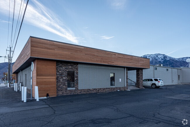
Property Record
150 E 400 N, Salem, UT 84653


Current Lease Availabilities
Property Detail
150 E 400 N
Provo-Orem-Lehi, UT
COM S 0 DEG 32 51 E 1612.38 FT & E 859.96 FT FR W 1/4 COR. SEC. 1, T9S, R2E, SLB&M.; N 0 DEG 23 4 E 444.24 FT; ALONG A CURVE TO R (CHORD BEARS: N 45 DEG 53 27 E 21.4 FT, RADIUS = 15 FT); S 88 DEG 36 9 E 87.73 FT; S 0 DEG 23 4 W 284.92 FT; S 89 DEG 16
09-054-0023
Utah
Lightindustrial
Utah
2024
1.38 AC
2025
Utah County
010407
Salt Lake City
53,281 SF
NEARBY LISTINGS FOR SALE OR LEASE
-
-
View all Salem listings for lease on LoopNet.com
DEMOGRAPHICS near 150 E 400 N
1 mile
3 mile
5 mile
2025 Total Population
5,544
26,469
88,761
2030 Population
6,159
29,457
97,710
Pop Growth 2025-2030
+ 11.09%
+ 11.29%
+ 10.08%
Average Age
35
34
33
2025 Total Households
1,574
7,170
24,406
HH Growth 2025-2030
+ 11.75%
+ 11.95%
+ 10.80%
Median Household Inc
$118,040
$117,439
$105,309
Avg Household Size
3.50
3.70
3.60
2025 Avg HH Vehicles
3.00
3.00
3.00
Median Home Value
$699,619
$648,568
$546,988
Median Year Built
2001
2004
2000
Nearby Places
Map Layers
Map Styles
 Street
 Aerial
Layers
 Traffic
 Biking
Places
Listings with unknown addresses are not visible on the map
- Restaurants
- Banks
- Shops
- Fitness
- Groceries
PUBLIC TRANSPORTATION
AIRPORT
Provo Municipal
Drive
Walk
Distance
Provo Municipal
23 min
14.2 mi
Freight Ports
Port of Stockton
Drive
Walk
Distance
Port of Stockton
772 min
750.8 mi
Nearby Properties
Address
Land Use
TOTAL SIZE
Lot Size
Zoning
Address
Land Use
TOTAL SIZE
Lot Size
Zoning
169,938 SF
8.96 AC
Address
Land Use
TOTAL SIZE
Lot Size
Zoning
92,323 SF
8.96 AC
Address
Land Use
TOTAL SIZE
Lot Size
Zoning
227,617 SF
8.44 AC
Address
Land Use
TOTAL SIZE
Lot Size
Zoning
729,831 SF
66.60 AC
RA5
Address
Land Use
TOTAL SIZE
Lot Size
Zoning
138,990 SF
6.57 AC
Address
Land Use
TOTAL SIZE
Lot Size
Zoning
122,808 SF
6.61 AC
Address
Land Use
TOTAL SIZE
Lot Size
Zoning
99,114 SF
3.67 AC
Address
Land Use
TOTAL SIZE
Lot Size
Zoning
90,004 SF
5.64 AC
Address
Land Use
TOTAL SIZE
Lot Size
Zoning
43,845 SF
4.95 AC
Address
Land Use
TOTAL SIZE
Lot Size
Zoning
125,459 SF
10 AC
Address
Land Use
TOTAL SIZE
Lot Size
Zoning
89,829 SF
5.04 AC
Address
Land Use
TOTAL SIZE
Lot Size
Zoning
17.20 AC
Address
Land Use
TOTAL SIZE
Lot Size
Zoning
221,351 SF
13.25 AC
Address
Land Use
TOTAL SIZE
Lot Size
Zoning
33.17 AC
Address
Land Use
TOTAL SIZE
Lot Size
Zoning
43,481 SF
1.62 AC
Address
Land Use
TOTAL SIZE
Lot Size
Zoning
36,173 SF
3.93 AC
RA5
Address
Land Use
TOTAL SIZE
Lot Size
Zoning
12,930 SF
5.54 AC
Address
Land Use
TOTAL SIZE
Lot Size
Zoning
21,396 SF
1.68 AC
Address
Land Use
TOTAL SIZE
Lot Size
Zoning
87,029 SF
4.18 AC
Address
Land Use
TOTAL SIZE
Lot Size
Zoning
3,671 SF
11.44 AC
Address
Land Use
TOTAL SIZE
Lot Size
Zoning
7,464 SF
2.07 AC
Address
Land Use
TOTAL SIZE
Lot Size
Zoning
5,885 SF
3.05 AC
Address
Land Use
TOTAL SIZE
Lot Size
Zoning
16,900 SF
15.54 AC
Address
Land Use
TOTAL SIZE
Lot Size
Zoning
17,609 SF
1.85 AC
Address
Land Use
TOTAL SIZE
Lot Size
Zoning
17,152 SF
0.75 AC
Address
Land Use
TOTAL SIZE
Lot Size
Zoning
15,025 SF
1 AC
Address
Land Use
TOTAL SIZE
Lot Size
Zoning
8.25 AC
Address
Land Use
TOTAL SIZE
Lot Size
Zoning
7,521 SF
1.20 AC
Address
Land Use
TOTAL SIZE
Lot Size
Zoning
5,885 SF
1.67 AC
The World's #1 Commercial Real Estate Marketplace
Connect with us
© 2026 CoStar Group
The information above has been obtained from sources believed reliable. While we do not doubt its accuracy we have not verified it and make no guarantee, warranty or representation about it. It is your responsibility to independently confirm its accuracy and completeness. Any projections, opinions, assumptions, or estimates used are for example only and do not represent the current or future performance of the property. The value of this transaction to you depends on tax and other factors which should be evaluated by your tax, financial, and legal advisors. You and your advisors should conduct a careful, independent investigation of the property to determine to your satisfaction the suitability of the property for your needs.