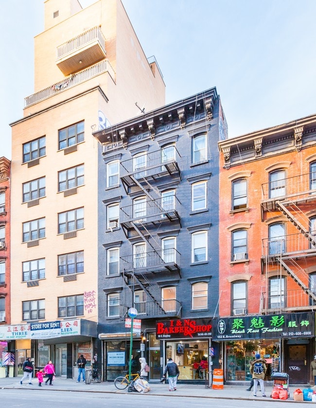
Property Record
150 E Broadway, New York, NY 10002

Property Detail
150 E Broadway
0283-0066
New York
Apartment
New York
C6-2
66
B and X Area of moderate flood hazard, usually the area between the limits of the 100-year and 500-year floods.
0.04 AC
2025
Chinatown
2026
New York City
000600
New York-Jersey City-White Plains, NY-NJ
6,225 SF
NEARBY LISTINGS FOR SALE OR LEASE
DEMOGRAPHICS near 150 E Broadway
1 mile
3 mile
5 mile
2025 Total Population
198,293
1,226,809
2,891,921
2030 Population
209,499
1,274,621
2,979,251
Pop Growth 2025-2030
+ 5.65%
+ 3.90%
+ 3.02%
Average Age
42
38
39
2025 Total Households
91,900
568,279
1,280,697
HH Growth 2025-2030
+ 6.00%
+ 4.12%
+ 3.39%
Median Household Inc
$82,446
$127,829
$109,487
Avg Household Size
2.00
2.00
2.10
2025 Avg HH Vehicles
.00
.00
.00
Median Home Value
$1,015,422
$1,022,490
$987,886
Median Year Built
1950
1958
1954
Nearby Places
Map Layers
Map Styles
 Street
 Aerial
Layers
 Traffic
 Biking
Places
Listings with unknown addresses are not visible on the map
- Restaurants
- Banks
- Shops
- Fitness
- Groceries
PUBLIC TRANSPORTATION
TRANSIT/SUBWAY
77 Street (R Line) (R - New York MTA Subway (The Subway))
Drive
Walk
Distance
77 Street (R Line) (R - New York MTA Subway (The Subway))
5 min
20 min
1.1 mi
COMMUTER RAIL
Tompkinsville (Staten Island Railway - New York MTA Subway (The Subway))
Drive
Walk
Distance
Tompkinsville (Staten Island Railway - New York MTA Subway (The Subway))
16 min
8.1 mi
St George (Staten Island Railway - New York MTA Subway (The Subway))
Drive
Walk
Distance
St George (Staten Island Railway - New York MTA Subway (The Subway))
19 min
8.7 mi
AIRPORT
LaGuardia
Drive
Walk
Distance
LaGuardia
33 min
19.3 mi
John F Kennedy International
Drive
Walk
Distance
John F Kennedy International
28 min
20.9 mi
Newark Liberty International
Drive
Walk
Distance
Newark Liberty International
33 min
21.4 mi
Freight Ports
GCT Bayonne
Drive
Walk
Distance
GCT Bayonne
30 min
17.3 mi
SALE & LEASE HISTORY
LISTING DATE
SALE/LEASE

Sep 24, 2016
For Lease
Oct 13, 2022
For Sale
Nov 09, 2017
For Lease
Nov 09, 2017
For Lease
May 09, 2022
For Lease
Mar 07, 2023
For Lease
Jul 19, 2017
For Sale
Apr 13, 2017
For Sale
Apr 12, 2017
For Sale
Apr 06, 2017
For Lease
Nearby Properties
Address
Land Use
TOTAL SIZE
Lot Size
Zoning
Address
Land Use
TOTAL SIZE
Lot Size
Zoning
Address
Land Use
TOTAL SIZE
Lot Size
Zoning
1,524,659 SF
170.96 AC
R4
Address
Land Use
TOTAL SIZE
Lot Size
Zoning
460,000 SF
3.21 AC
R6
Address
Land Use
TOTAL SIZE
Lot Size
Zoning
335,800 SF
1.51 AC
R6
Address
Land Use
TOTAL SIZE
Lot Size
Zoning
1,324,592 SF
5.13 AC
M3-1
Address
Land Use
TOTAL SIZE
Lot Size
Zoning
30.92 AC
Address
Land Use
TOTAL SIZE
Lot Size
Zoning
397,354 SF
0.61 AC
C5-2
Address
Land Use
TOTAL SIZE
Lot Size
Zoning
114.66 AC
BMHO
Address
Land Use
TOTAL SIZE
Lot Size
Zoning
115.33 AC
IH
Address
Land Use
TOTAL SIZE
Lot Size
Zoning
236,591 SF
207.66 AC
R3-2
Address
Land Use
TOTAL SIZE
Lot Size
Zoning
73.85 AC
IH
Address
Land Use
TOTAL SIZE
Lot Size
Zoning
538,240 SF
12.08 AC
R2
Address
Land Use
TOTAL SIZE
Lot Size
Zoning
5,359,400 SF
59.07 AC
M2-1
Address
Land Use
TOTAL SIZE
Lot Size
Zoning
25.67 AC
Address
Land Use
TOTAL SIZE
Lot Size
Zoning
286,000 SF
12.63 AC
PARK
Address
Land Use
TOTAL SIZE
Lot Size
Zoning
521,405 SF
52.79 AC
R3-1
Address
Land Use
TOTAL SIZE
Lot Size
Zoning
3,970,000 SF
91.14 AC
M3-1
Address
Land Use
TOTAL SIZE
Lot Size
Zoning
689,850 SF
3.08 AC
M3-1
Address
Land Use
TOTAL SIZE
Lot Size
Zoning
Address
Land Use
TOTAL SIZE
Lot Size
Zoning
48.68 AC
IH
Address
Land Use
TOTAL SIZE
Lot Size
Zoning
673,895 SF
3.22 AC
M3-1
Address
Land Use
TOTAL SIZE
Lot Size
Zoning
Address
Land Use
TOTAL SIZE
Lot Size
Zoning
492,962 SF
8.12 AC
M1-1
Address
Land Use
TOTAL SIZE
Lot Size
Zoning
11 AC
WR
Address
Land Use
TOTAL SIZE
Lot Size
Zoning
171,591 SF
0.14 AC
C5-2
Address
Land Use
TOTAL SIZE
Lot Size
Zoning
581,250 SF
3.22 AC
M3-1
Address
Land Use
TOTAL SIZE
Lot Size
Zoning
19.26 AC
IH
Address
Land Use
TOTAL SIZE
Lot Size
Zoning
183,839 SF
9.74 AC
PARK
Address
Land Use
TOTAL SIZE
Lot Size
Zoning
23.72 AC
IH
Address
Land Use
TOTAL SIZE
Lot Size
Zoning
26,826 SF
9 AC
IH
The World's #1 Commercial Real Estate Marketplace
Connect with us
© 2026 CoStar Group
The information above has been obtained from sources believed reliable. While we do not doubt its accuracy we have not verified it and make no guarantee, warranty or representation about it. It is your responsibility to independently confirm its accuracy and completeness. Any projections, opinions, assumptions, or estimates used are for example only and do not represent the current or future performance of the property. The value of this transaction to you depends on tax and other factors which should be evaluated by your tax, financial, and legal advisors. You and your advisors should conduct a careful, independent investigation of the property to determine to your satisfaction the suitability of the property for your needs.