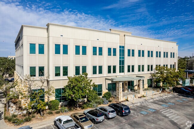
Property Record
150 E Sonterra Blvd, San Antonio, TX 78258


Current Lease Availabilities
Property Detail
150 E Sonterra Blvd
San Antonio-New Braunfels, TX
NCB 16332 BLK 2 LOT 8 EXC NW 10.58FT X 40.43FT 3.99 AC (STONETERRA OFFICE PARK) 2012 SPLIT NEW REMS PER DEED 14885/0645
16332-002-0080
BEXAR
Medicalbuilding
Texas
B and X Area of moderate flood hazard, usually the area between the limits of the 100-year and 500-year floods.
8
2024
3.99 AC
2025
Far North Central
191818
San Antonio
60,825 SF
NEARBY LISTINGS FOR SALE OR LEASE
DEMOGRAPHICS near 150 E Sonterra Blvd
1 mile
3 mile
5 mile
2025 Total Population
9,165
80,816
206,430
2030 Population
9,647
84,682
216,747
Pop Growth 2025-2030
+ 5.26%
+ 4.78%
+ 5.00%
Average Age
42
40
40
2025 Total Households
4,103
32,003
82,805
HH Growth 2025-2030
+ 5.48%
+ 4.97%
+ 5.14%
Median Household Inc
$89,143
$102,580
$99,356
Avg Household Size
2.10
2.50
2.50
2025 Avg HH Vehicles
2.00
2.00
2.00
Median Home Value
$479,257
$432,036
$418,594
Median Year Built
1999
1997
1996
Nearby Places
Map Layers
Map Styles
 Street
 Aerial
Layers
 Traffic
 Biking
Places
Listings with unknown addresses are not visible on the map
- Restaurants
- Banks
- Shops
- Fitness
- Groceries
PUBLIC TRANSPORTATION
AIRPORT
San Antonio International
Drive
Walk
Distance
San Antonio International
13 min
8.8 mi
Nearby Properties
Address
Land Use
TOTAL SIZE
Lot Size
Zoning
Address
Land Use
TOTAL SIZE
Lot Size
Zoning
621,591 SF
15.25 AC
Address
Land Use
TOTAL SIZE
Lot Size
Zoning
427,456 SF
37.12 AC
Address
Land Use
TOTAL SIZE
Lot Size
Zoning
631,284 SF
14.61 AC
Address
Land Use
TOTAL SIZE
Lot Size
Zoning
387,893 SF
11.97 AC
Address
Land Use
TOTAL SIZE
Lot Size
Zoning
352,144 SF
29.83 AC
Address
Land Use
TOTAL SIZE
Lot Size
Zoning
311,728 SF
7.47 AC
Address
Land Use
TOTAL SIZE
Lot Size
Zoning
480,363 SF
28.52 AC
Address
Land Use
TOTAL SIZE
Lot Size
Zoning
292,126 SF
12.86 AC
Address
Land Use
TOTAL SIZE
Lot Size
Zoning
315,719 SF
13.91 AC
Address
Land Use
TOTAL SIZE
Lot Size
Zoning
364,026 SF
27.34 AC
Address
Land Use
TOTAL SIZE
Lot Size
Zoning
303,085 SF
12.42 AC
Address
Land Use
TOTAL SIZE
Lot Size
Zoning
309,507 SF
14.95 AC
Address
Land Use
TOTAL SIZE
Lot Size
Zoning
177,316 SF
19.83 AC
Address
Land Use
TOTAL SIZE
Lot Size
Zoning
209,715 SF
22.91 AC
Address
Land Use
TOTAL SIZE
Lot Size
Zoning
323,716 SF
19.74 AC
Address
Land Use
TOTAL SIZE
Lot Size
Zoning
327,760 SF
18.75 AC
Address
Land Use
TOTAL SIZE
Lot Size
Zoning
284,202 SF
13.59 AC
Address
Land Use
TOTAL SIZE
Lot Size
Zoning
138,292 SF
17.91 AC
Address
Land Use
TOTAL SIZE
Lot Size
Zoning
317,041 SF
26.69 AC
Address
Land Use
TOTAL SIZE
Lot Size
Zoning
289,271 SF
16.87 AC
Address
Land Use
TOTAL SIZE
Lot Size
Zoning
234,914 SF
16.29 AC
Address
Land Use
TOTAL SIZE
Lot Size
Zoning
154,937 SF
22 AC
Address
Land Use
TOTAL SIZE
Lot Size
Zoning
269,525 SF
17.75 AC
Address
Land Use
TOTAL SIZE
Lot Size
Zoning
341,841 SF
22 AC
Address
Land Use
TOTAL SIZE
Lot Size
Zoning
249,562 SF
9.65 AC
Address
Land Use
TOTAL SIZE
Lot Size
Zoning
340,570 SF
19.15 AC
Address
Land Use
TOTAL SIZE
Lot Size
Zoning
281,805 SF
14.52 AC
Address
Land Use
TOTAL SIZE
Lot Size
Zoning
99,301 SF
13.49 AC
Address
Land Use
TOTAL SIZE
Lot Size
Zoning
273,257 SF
17.62 AC
Address
Land Use
TOTAL SIZE
Lot Size
Zoning
297,882 SF
17.16 AC
The World's #1 Commercial Real Estate Marketplace
Connect with us
© 2026 CoStar Group
The information above has been obtained from sources believed reliable. While we do not doubt its accuracy we have not verified it and make no guarantee, warranty or representation about it. It is your responsibility to independently confirm its accuracy and completeness. Any projections, opinions, assumptions, or estimates used are for example only and do not represent the current or future performance of the property. The value of this transaction to you depends on tax and other factors which should be evaluated by your tax, financial, and legal advisors. You and your advisors should conduct a careful, independent investigation of the property to determine to your satisfaction the suitability of the property for your needs.