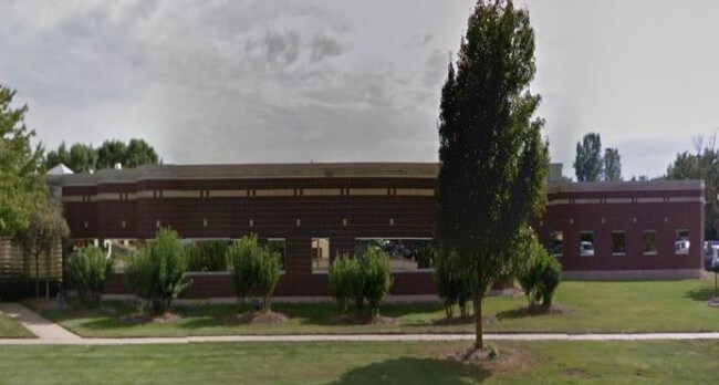
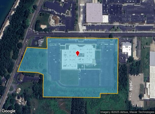
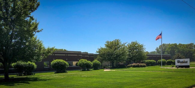
Property Record
150 Hilltop Rd, Saint Joseph, MI 49085
NEARBY LISTINGS FOR SALE OR LEASE
Property Detail
150 Hilltop Rd
11-76-0034-0084-01-1
COM 200'E & 33'S 0 DEG 03'W OF NE COR OF NW1/4 OF SE1/4 SEC 34 T4S R19W TH W 807'TH S 0 DEG 03'W 115' TH N88DEG 05'W 227.25'TO ELY LN OF HWY TH S20 DEG56'W 274.69'TH S87 DEG 02'E 223.65'TH S74DEG28'E 60.7 FT TH S 0 DEG 03'W 289.77'TH N89 DEG36'E 649.
Commercialnec
Berrien
X
Michigan
26021C0084D
14.22 AC
2024
Michigan Southwest Area
2025
Other Market Areas
000900
Niles-Benton Harbor, MI
73,680 SF
DEMOGRAPHICS near 150 Hilltop Rd
1 Mile
3 Mile
5 Mile
2024 Total Population
2,626
23,731
49,915
2029 Population
2,542
23,192
49,139
Pop Growth 2024-2029
(3.20%)
(2.27%)
(1.55%)
Average Age
43
43
41
2024 Total Households
1,379
10,655
20,841
HH Growth 2024-2029
(3.48%)
(2.45%)
(1.83%)
Median Household Inc
$55,164
$69,313
$57,480
Avg Household Size
1.90
2.20
2.30
2024 Avg HH Vehicles
2.00
2.00
2.00
Median Home Value
$213,598
$213,929
$218,149
Median Year Built
1968
1961
1965
Nearby Places
Map Layers
Map Styles
 Street
 Aerial
- Restaurants
- Banks
- Shops
- Fitness
- Groceries
PUBLIC TRANSPORTATION
COMMUTER RAIL
St. Joseph-Benton Harbor Amtrak Station (Pere Marquette - Amtrak)
DRIVE
WALK
Distance
St. Joseph-Benton Harbor Amtrak Station (Pere Marquette - Amtrak)
7 min
3.2 mi
AIRPORT
South Bend International
DRIVE
WALK
Distance
South Bend International
51 min
33.3 mi
Freight Ports
Port Milwaukee
DRIVE
WALK
Distance
Port Milwaukee
216 min
179.0 mi
SALE & LEASE HISTORY
LISTING DATE
SALE/LEASE

Jun 26, 2018
For Sale
Nearby Properties
Address
Land Use
TOTAL SIZE
Lot Size
Zoning
Address
Land Use
TOTAL SIZE
Lot Size
Zoning
313,588 SF
11.48 AC
DISTRICT A
Address
Land Use
TOTAL SIZE
Lot Size
Zoning
216,232 SF
Address
Land Use
TOTAL SIZE
Lot Size
Zoning
Address
Land Use
TOTAL SIZE
Lot Size
Zoning
125,408 SF
4.66 AC
R-3
Address
Land Use
TOTAL SIZE
Lot Size
Zoning
89,062 SF
1.60 AC
W
Address
Land Use
TOTAL SIZE
Lot Size
Zoning
99,468 SF
10.07 AC
DISTRICT G
Address
Land Use
TOTAL SIZE
Lot Size
Zoning
87,978 SF
4.36 AC
R2 MDR
Address
Land Use
TOTAL SIZE
Lot Size
Zoning
73,680 SF
CO-A
Address
Land Use
TOTAL SIZE
Lot Size
Zoning
202,713 SF
14.23 AC
CO-A
Address
Land Use
TOTAL SIZE
Lot Size
Zoning
30,889 SF
2.83 AC
CO-A
Address
Land Use
TOTAL SIZE
Lot Size
Zoning
53,504 SF
Address
Land Use
TOTAL SIZE
Lot Size
Zoning
69,750 SF
0.47 AC
D
Address
Land Use
TOTAL SIZE
Lot Size
Zoning
42,610 SF
5.30 AC
C4 HEAVY
Address
Land Use
TOTAL SIZE
Lot Size
Zoning
330,000 SF
20.56 AC
I1
Address
Land Use
TOTAL SIZE
Lot Size
Zoning
28,312 SF
4.30 AC
C
Address
Land Use
TOTAL SIZE
Lot Size
Zoning
93,032 SF
0.51 AC
D
Address
Land Use
TOTAL SIZE
Lot Size
Zoning
82,567 SF
1.74 AC
D
Address
Land Use
TOTAL SIZE
Lot Size
Zoning
150,421 SF
10.30 AC
HD
Address
Land Use
TOTAL SIZE
Lot Size
Zoning
90,000 SF
7.62 AC
W
Address
Land Use
TOTAL SIZE
Lot Size
Zoning
519,203 SF
25.57 AC
C
Address
Land Use
TOTAL SIZE
Lot Size
Zoning
65,584 SF
6.52 AC
CO-A
Address
Land Use
TOTAL SIZE
Lot Size
Zoning
25,080 SF
I-1
Address
Land Use
TOTAL SIZE
Lot Size
Zoning
55,753 SF
6 AC
DISTRICT D
Address
Land Use
TOTAL SIZE
Lot Size
Zoning
403,396 SF
37.17 AC
HI
Address
Land Use
TOTAL SIZE
Lot Size
Zoning
54,750 SF
5.87 AC
CMU
Address
Land Use
TOTAL SIZE
Lot Size
Zoning
89,420 SF
7.89 AC
R3 - SINGL
Address
Land Use
TOTAL SIZE
Lot Size
Zoning
39,473 SF
2.90 AC
CO-A
Address
Land Use
TOTAL SIZE
Lot Size
Zoning
60,252 SF
3.17 AC
C
Address
Land Use
TOTAL SIZE
Lot Size
Zoning
Address
Land Use
TOTAL SIZE
Lot Size
Zoning
67,200 SF
3.90 AC
R-3
The World's #1 Commercial Real Estate Marketplace
Connect with us
© 2025 CoStar Group
The information above has been obtained from sources believed reliable. While we do not doubt its accuracy we have not verified it and make no guarantee, warranty or representation about it. It is your responsibility to independently confirm its accuracy and completeness. Any projections, opinions, assumptions, or estimates used are for example only and do not represent the current or future performance of the property. The value of this transaction to you depends on tax and other factors which should be evaluated by your tax, financial, and legal advisors. You and your advisors should conduct a careful, independent investigation of the property to determine to your satisfaction the suitability of the property for your needs.