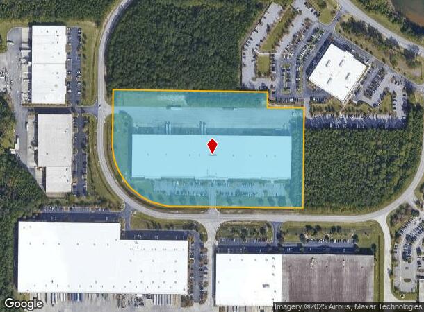
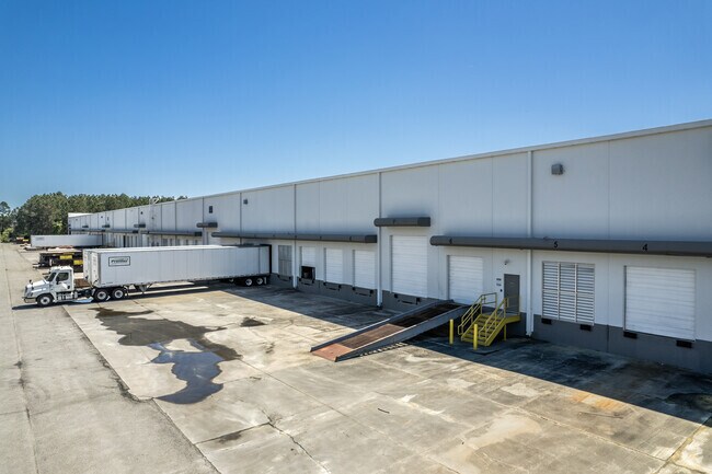
Property Record
150 Knowlton Way, Port Wentworth, GA 31407

NEARBY LISTINGS FOR SALE OR LEASE
Property Detail
150 Knowlton Way
Savannah, GA
Crossroads Business Center
2098201033
LOT 2A CROSSROADS BUSINESS CENT ER SMB 33S 62 10.82 AC PRB 47
Publicstorage
Chatham
X
Georgia
45053C0475D
2
0
10.82 AC
2025
N Savannah/Garden City
010701
Savannah
146,250 SF
DEMOGRAPHICS near 150 Knowlton Way
1 Mile
3 Mile
5 Mile
2024 Total Population
2,544
28,184
51,024
2029 Population
2,697
29,715
54,283
Pop Growth 2024-2029
+ 6.01%
+ 5.43%
+ 6.39%
Average Age
35
36
37
2024 Total Households
1,143
10,638
19,109
HH Growth 2024-2029
+ 5.60%
+ 5.52%
+ 6.39%
Median Household Inc
$83,070
$87,557
$80,964
Avg Household Size
2.20
2.50
2.50
2024 Avg HH Vehicles
2.00
2.00
2.00
Median Home Value
$247,863
$236,255
$219,580
Median Year Built
2010
2010
2006
Nearby Places
Map Layers
Map Styles
 Street
 Aerial
- Restaurants
- Banks
- Shops
- Fitness
- Groceries
PUBLIC TRANSPORTATION
AIRPORT
Savannah/Hilton Head International
DRIVE
WALK
Distance
Savannah/Hilton Head International
19 min
4.9 mi
Hilton Head
DRIVE
WALK
Distance
Hilton Head
56 min
40.9 mi
SALE & LEASE HISTORY
LISTING DATE
SALE/LEASE

Jan 29, 2024
For Lease
Nearby Properties
Address
Land Use
TOTAL SIZE
Lot Size
Zoning
Address
Land Use
TOTAL SIZE
Lot Size
Zoning
1,400,224 SF
325.62 AC
I-H
Address
Land Use
TOTAL SIZE
Lot Size
Zoning
426,547 SF
15.29 AC
Address
Land Use
TOTAL SIZE
Lot Size
Zoning
432,965 SF
10.09 AC
Address
Land Use
TOTAL SIZE
Lot Size
Zoning
605,200 SF
59.62 AC
I-H
Address
Land Use
TOTAL SIZE
Lot Size
Zoning
42,338 SF
65.96 AC
PUD
Address
Land Use
TOTAL SIZE
Lot Size
Zoning
588,726 SF
0.30 AC
I-L
Address
Land Use
TOTAL SIZE
Lot Size
Zoning
1,584 SF
67.35 AC
I1
Address
Land Use
TOTAL SIZE
Lot Size
Zoning
800,100 SF
44.51 AC
I-H
Address
Land Use
TOTAL SIZE
Lot Size
Zoning
944,260 SF
56.31 AC
I-1
Address
Land Use
TOTAL SIZE
Lot Size
Zoning
754,000 SF
63.38 AC
I-H
Address
Land Use
TOTAL SIZE
Lot Size
Zoning
728,500 SF
67.67 AC
Address
Land Use
TOTAL SIZE
Lot Size
Zoning
70,000 SF
71.90 AC
IH
Address
Land Use
TOTAL SIZE
Lot Size
Zoning
70.39 AC
Address
Land Use
TOTAL SIZE
Lot Size
Zoning
24,648 SF
23.38 AC
Address
Land Use
TOTAL SIZE
Lot Size
Zoning
631,800 SF
38.47 AC
Address
Land Use
TOTAL SIZE
Lot Size
Zoning
103,840 SF
49.10 AC
I-L
Address
Land Use
TOTAL SIZE
Lot Size
Zoning
2,000 SF
24.74 AC
PUDCC
Address
Land Use
TOTAL SIZE
Lot Size
Zoning
9,505 SF
0.07 AC
Address
Land Use
TOTAL SIZE
Lot Size
Zoning
547,528 SF
67.26 AC
I-1
Address
Land Use
TOTAL SIZE
Lot Size
Zoning
285,905 SF
20.16 AC
I-L
Address
Land Use
TOTAL SIZE
Lot Size
Zoning
109,284 SF
24.54 AC
R-3-B
Address
Land Use
TOTAL SIZE
Lot Size
Zoning
4,888 SF
37.80 AC
PUDC
Address
Land Use
TOTAL SIZE
Lot Size
Zoning
25,656 SF
23.69 AC
PUDC
Address
Land Use
TOTAL SIZE
Lot Size
Zoning
2,156 SF
36.64 AC
PIL
Address
Land Use
TOTAL SIZE
Lot Size
Zoning
10,600 SF
21.93 AC
PUD
Address
Land Use
TOTAL SIZE
Lot Size
Zoning
23,946 SF
22.68 AC
PUDC
Address
Land Use
TOTAL SIZE
Lot Size
Zoning
3,648 SF
66.30 AC
I-L
Address
Land Use
TOTAL SIZE
Lot Size
Zoning
22,220 SF
27.20 AC
PUDC
Address
Land Use
TOTAL SIZE
Lot Size
Zoning
499,200 SF
33.02 AC
PUDC
Address
Land Use
TOTAL SIZE
Lot Size
Zoning
35,352 SF
21.22 AC
PUD
The World's #1 Commercial Real Estate Marketplace
Connect with us
© 2025 CoStar Group
The information above has been obtained from sources believed reliable. While we do not doubt its accuracy we have not verified it and make no guarantee, warranty or representation about it. It is your responsibility to independently confirm its accuracy and completeness. Any projections, opinions, assumptions, or estimates used are for example only and do not represent the current or future performance of the property. The value of this transaction to you depends on tax and other factors which should be evaluated by your tax, financial, and legal advisors. You and your advisors should conduct a careful, independent investigation of the property to determine to your satisfaction the suitability of the property for your needs.