Property Record
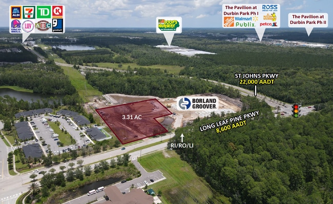
150 Longleaf Pine Pkwy, Saint Johns, FL 32259


Property Detail
150 Longleaf Pine Pkwy
023630-0083
2-8C PT OF SEC 7 LYING N OF LONGLEAF PINE PKWY & W OF VACA RUSSELL SAMPSON RD & E OF HERON LANDING RD (EX PT IN OR4490/969) (EX PT IN OR6160/1106) OR5542/227
Commercialnec
ST. JOHNS
A Areas with a 1% annual chance of flooding and a 26% chance of flooding over the life of a 30-year mortgage.
Florida
2025
6.32 AC
2026
St Johns County
020808
Jacksonville (Florida)
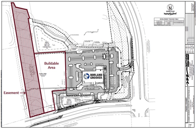
38,266 SF
Jacksonville, FL
NEARBY LISTINGS FOR SALE OR LEASE
DEMOGRAPHICS near 150 Longleaf Pine Pkwy
1 mile
3 mile
5 mile
2025 Total Population
4,673
46,106
109,552
2030 Population
5,449
52,298
124,770
Pop Growth 2025-2030
+ 16.61%
+ 13.43%
+ 13.89%
Average Age
35
36
37
2025 Total Households
1,387
15,554
37,763
HH Growth 2025-2030
+ 16.87%
+ 13.05%
+ 13.69%
Median Household Inc
$176,136
$133,960
$124,986
Avg Household Size
3.40
2.90
2.90
2025 Avg HH Vehicles
2.00
2.00
2.00
Median Home Value
$666,186
$491,032
$485,833
Median Year Built
2011
2010
2010
Nearby Places
Map Layers
Map Styles
 Street
 Aerial
Layers
 Traffic
 Biking
Places
Listings with unknown addresses are not visible on the map
- Restaurants
- Banks
- Shops
- Fitness
- Groceries
PUBLIC TRANSPORTATION
AIRPORT
Jacksonville International
Drive
Walk
Distance
Jacksonville International
47 min
36.0 mi
Freight Ports
Jacksonville Port
Drive
Walk
Distance
Jacksonville Port
35 min
25.0 mi
SALE & LEASE HISTORY
LISTING DATE
SALE/LEASE

Aug 02, 2023
For Sale
Nearby Properties
Address
Land Use
TOTAL SIZE
Lot Size
Zoning
Address
Land Use
TOTAL SIZE
Lot Size
Zoning
534,591 SF
39.81 AC
PUD
Address
Land Use
TOTAL SIZE
Lot Size
Zoning
420,652 SF
32.41 AC
PUD
Address
Land Use
TOTAL SIZE
Lot Size
Zoning
450,888 SF
27.01 AC
PUD
Address
Land Use
TOTAL SIZE
Lot Size
Zoning
381,269 SF
25.73 AC
PUD
Address
Land Use
TOTAL SIZE
Lot Size
Zoning
340,852 SF
19.65 AC
PUD
Address
Land Use
TOTAL SIZE
Lot Size
Zoning
311,304 SF
18.93 AC
PUD
Address
Land Use
TOTAL SIZE
Lot Size
Zoning
371,039 SF
20.63 AC
Address
Land Use
TOTAL SIZE
Lot Size
Zoning
153,270 SF
15.96 AC
OR
Address
Land Use
TOTAL SIZE
Lot Size
Zoning
241,882 SF
10.83 AC
PUD
Address
Land Use
TOTAL SIZE
Lot Size
Zoning
427,236 SF
69.60 AC
PUD
Address
Land Use
TOTAL SIZE
Lot Size
Zoning
211,499 SF
74.05 AC
Address
Land Use
TOTAL SIZE
Lot Size
Zoning
378,384 SF
21 AC
Address
Land Use
TOTAL SIZE
Lot Size
Zoning
300,261 SF
9.95 AC
Address
Land Use
TOTAL SIZE
Lot Size
Zoning
295,881 SF
38.96 AC
Address
Land Use
TOTAL SIZE
Lot Size
Zoning
288,257 SF
16.56 AC
Address
Land Use
TOTAL SIZE
Lot Size
Zoning
233,849 SF
101.31 AC
OR
Address
Land Use
TOTAL SIZE
Lot Size
Zoning
Address
Land Use
TOTAL SIZE
Lot Size
Zoning
84,096 SF
12.75 AC
OR
Address
Land Use
TOTAL SIZE
Lot Size
Zoning
158,388 SF
33.46 AC
OR
Address
Land Use
TOTAL SIZE
Lot Size
Zoning
148,628 SF
8.91 AC
Address
Land Use
TOTAL SIZE
Lot Size
Zoning
78,903 SF
22.19 AC
Address
Land Use
TOTAL SIZE
Lot Size
Zoning
79,647 SF
13.02 AC
Address
Land Use
TOTAL SIZE
Lot Size
Zoning
64,525 SF
6.91 AC
PUD
Address
Land Use
TOTAL SIZE
Lot Size
Zoning
42.82 AC
Address
Land Use
TOTAL SIZE
Lot Size
Zoning
63,078 SF
12.20 AC
PUD
Address
Land Use
TOTAL SIZE
Lot Size
Zoning
191,230 SF
17.62 AC
Address
Land Use
TOTAL SIZE
Lot Size
Zoning
Address
Land Use
TOTAL SIZE
Lot Size
Zoning
61,942 SF
44.39 AC
Address
Land Use
TOTAL SIZE
Lot Size
Zoning
80,540 SF
15.46 AC
PUD
Address
Land Use
TOTAL SIZE
Lot Size
Zoning
70,936 SF
8.88 AC
PUD
The World's #1 Commercial Real Estate Marketplace
Connect with us
© 2026 CoStar Group
The information above has been obtained from sources believed reliable. While we do not doubt its accuracy we have not verified it and make no guarantee, warranty or representation about it. It is your responsibility to independently confirm its accuracy and completeness. Any projections, opinions, assumptions, or estimates used are for example only and do not represent the current or future performance of the property. The value of this transaction to you depends on tax and other factors which should be evaluated by your tax, financial, and legal advisors. You and your advisors should conduct a careful, independent investigation of the property to determine to your satisfaction the suitability of the property for your needs.