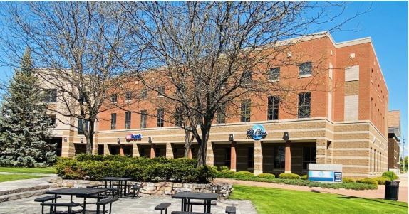
Property Record
150 Main St, Menasha, WI 54952


Current Lease Availabilities
NEARBY LISTINGS FOR SALE OR LEASE
Property Detail
150 Main St
Oshkosh-Neenah, WI
Csm #3742
2-00118-00
LOT 1 OF CSM #3742 REC AS DOC #975140 WINNEBAGO CO R.O.D.
Commercialnec
Winnebago
X
Wisconsin
55087C0430D
1
2024
1.31 AC
2024
Appleton/Oshkosh
002900
Other Market Areas
55,633 SF
DEMOGRAPHICS near 150 Main St
1 Mile
3 Mile
5 Mile
2024 Total Population
9,328
47,960
111,788
2029 Population
9,340
48,001
113,356
Pop Growth 2024-2029
+ 0.13%
+ 0.09%
+ 1.40%
Average Age
39
40
39
2024 Total Households
4,058
20,711
47,023
HH Growth 2024-2029
(0.05%)
(0.06%)
+ 1.31%
Median Household Inc
$57,420
$60,375
$65,703
Avg Household Size
2.20
2.30
2.30
2024 Avg HH Vehicles
2.00
2.00
2.00
Median Home Value
$149,050
$170,465
$184,476
Median Year Built
1949
1969
1974
Nearby Places
- Restaurants
- Banks
- Shops
- Fitness
- Groceries
PUBLIC TRANSPORTATION
AIRPORT
Appleton International
DRIVE
WALK
Distance
Appleton International
15 min
7.6 mi
Green Bay/Austin Straubel International
DRIVE
WALK
Distance
Green Bay/Austin Straubel International
43 min
32.6 mi
Freight Ports
Port Milwaukee
DRIVE
WALK
Distance
Port Milwaukee
121 min
103.1 mi
Nearby Properties
Address
Land Use
TOTAL SIZE
Lot Size
Zoning
Address
Land Use
TOTAL SIZE
Lot Size
Zoning
8.61 AC
R5
Address
Land Use
TOTAL SIZE
Lot Size
Zoning
156.36 AC
M1
Address
Land Use
TOTAL SIZE
Lot Size
Zoning
11.99 AC
Address
Land Use
TOTAL SIZE
Lot Size
Zoning
120.73 AC
M2
Address
Land Use
TOTAL SIZE
Lot Size
Zoning
11.22 AC
Address
Land Use
TOTAL SIZE
Lot Size
Zoning
9.40 AC
Address
Land Use
TOTAL SIZE
Lot Size
Zoning
11,340 SF
0.92 AC
C2
Address
Land Use
TOTAL SIZE
Lot Size
Zoning
178,750 SF
0.43 AC
C2
Address
Land Use
TOTAL SIZE
Lot Size
Zoning
59,584 SF
12.11 AC
C1
Address
Land Use
TOTAL SIZE
Lot Size
Zoning
103,427 SF
0.56 AC
PDD
Address
Land Use
TOTAL SIZE
Lot Size
Zoning
6.75 AC
M1
Address
Land Use
TOTAL SIZE
Lot Size
Zoning
89,042 SF
2.83 AC
C2
Address
Land Use
TOTAL SIZE
Lot Size
Zoning
101,466 SF
13.87 AC
Address
Land Use
TOTAL SIZE
Lot Size
Zoning
89,576 SF
1.03 AC
C2
Address
Land Use
TOTAL SIZE
Lot Size
Zoning
105,852 SF
0.39 AC
PDD
Address
Land Use
TOTAL SIZE
Lot Size
Zoning
67.41 AC
I2
Address
Land Use
TOTAL SIZE
Lot Size
Zoning
15.73 AC
B5
Address
Land Use
TOTAL SIZE
Lot Size
Zoning
210,214 SF
16.44 AC
I1
Address
Land Use
TOTAL SIZE
Lot Size
Zoning
86,455 SF
PDD
Address
Land Use
TOTAL SIZE
Lot Size
Zoning
25.62 AC
I2
Address
Land Use
TOTAL SIZE
Lot Size
Zoning
361,899 SF
18.54 AC
I2
Address
Land Use
TOTAL SIZE
Lot Size
Zoning
20.92 AC
R5
Address
Land Use
TOTAL SIZE
Lot Size
Zoning
4.33 AC
Address
Land Use
TOTAL SIZE
Lot Size
Zoning
20,874 SF
11.57 AC
R4
Address
Land Use
TOTAL SIZE
Lot Size
Zoning
67,817 SF
21.36 AC
C2
Address
Land Use
TOTAL SIZE
Lot Size
Zoning
74,603 SF
4.96 AC
I1
Address
Land Use
TOTAL SIZE
Lot Size
Zoning
7.29 AC
Address
Land Use
TOTAL SIZE
Lot Size
Zoning
78,268 SF
7.80 AC
C3
Address
Land Use
TOTAL SIZE
Lot Size
Zoning
92,030 SF
7.79 AC
I1
Address
Land Use
TOTAL SIZE
Lot Size
Zoning
145,322 SF
11.20 AC
PDD
The World's #1 Commercial Real Estate Marketplace
Connect with us
© 2025 CoStar Group
The information above has been obtained from sources believed reliable. While we do not doubt its accuracy we have not verified it and make no guarantee, warranty or representation about it. It is your responsibility to independently confirm its accuracy and completeness. Any projections, opinions, assumptions, or estimates used are for example only and do not represent the current or future performance of the property. The value of this transaction to you depends on tax and other factors which should be evaluated by your tax, financial, and legal advisors. You and your advisors should conduct a careful, independent investigation of the property to determine to your satisfaction the suitability of the property for your needs.