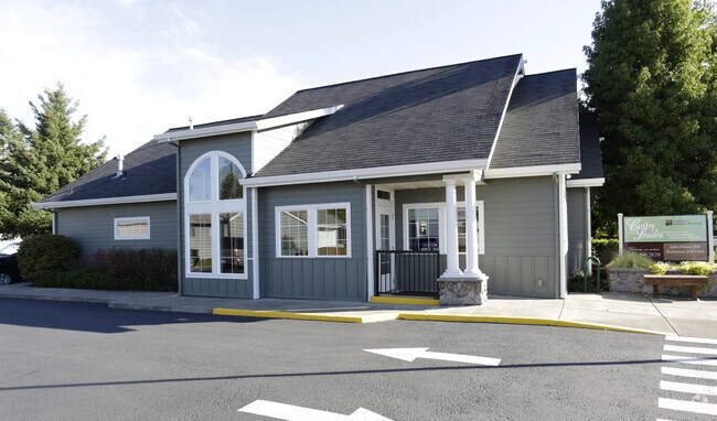
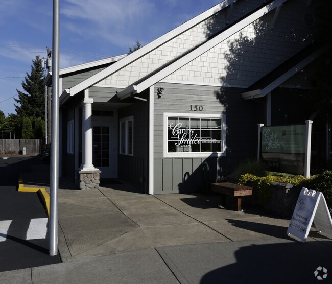
Property Record
150 Ne 3Rd Ave, Canby, OR 97013

Save to a Folder
{{folder.Name}}
{{folder.ListingIds.length}} Properties
{{folder.ListingIds.length}} Property
Create a New Folder
Property Detail
150 Ne 3Rd Ave
Portland-Vancouver-Hillsboro, OR-WA
98 LEES ADD LT 3&4 BLK 1
00791236
Clackamas
Commercialbuilding
Oregon
C1
3,4
B and X Area of moderate flood hazard, usually the area between the limits of the 100-year and 500-year floods.
0.27 AC
2025
SE Outlying
2025
Portland
022904
NEARBY LISTINGS FOR SALE OR LEASE
DEMOGRAPHICS near 150 Ne 3Rd Ave
1 mile
3 mile
5 mile
2025 Total Population
14,126
22,473
42,733
2030 Population
14,230
22,702
43,023
Pop Growth 2025-2030
+ 0.74%
+ 1.02%
+ 0.68%
Average Age
41
42
43
2025 Total Households
5,135
8,173
16,612
HH Growth 2025-2030
+ 0.80%
+ 1.06%
+ 0.69%
Median Household Inc
$100,616
$101,918
$93,604
Avg Household Size
2.70
2.70
2.50
2025 Avg HH Vehicles
2.00
2.00
2.00
Median Home Value
$482,024
$537,524
$607,342
Median Year Built
1988
1991
1991
Nearby Places
Map Layers
Map Styles
 Street
 Aerial
Layers
 Traffic
 Biking
Places
Listings with unknown addresses are not visible on the map
- Restaurants
- Banks
- Shops
- Fitness
- Groceries
PUBLIC TRANSPORTATION
COMMUTER RAIL
Wilsonville (Westside Express Service - Tri-County Metropolitan Transportation District of Oregon Rail (TriMet Rail))
Drive
Walk
Distance
Wilsonville (Westside Express Service - Tri-County Metropolitan Transportation District of Oregon Rail (TriMet Rail))
17 min
8.6 mi
Drive
Walk
Distance
18 min
9.8 mi
AIRPORT
Portland International
Drive
Walk
Distance
Portland International
44 min
27.6 mi
Nearby Properties
Address
Land Use
TOTAL SIZE
Lot Size
Zoning
Address
Land Use
TOTAL SIZE
Lot Size
Zoning
Address
Land Use
TOTAL SIZE
Lot Size
Zoning
35.33 AC
M1
Address
Land Use
TOTAL SIZE
Lot Size
Zoning
1,432 SF
12.96 AC
CM
Address
Land Use
TOTAL SIZE
Lot Size
Zoning
10 AC
M2
Address
Land Use
TOTAL SIZE
Lot Size
Zoning
4.88 AC
R1.5
Address
Land Use
TOTAL SIZE
Lot Size
Zoning
9.26 AC
M1
Address
Land Use
TOTAL SIZE
Lot Size
Zoning
17.39 AC
M1
Address
Land Use
TOTAL SIZE
Lot Size
Zoning
15.17 AC
M2
Address
Land Use
TOTAL SIZE
Lot Size
Zoning
Address
Land Use
TOTAL SIZE
Lot Size
Zoning
1 SF
7 AC
C2
Address
Land Use
TOTAL SIZE
Lot Size
Zoning
828 SF
0.74 AC
C1
Address
Land Use
TOTAL SIZE
Lot Size
Zoning
6.11 AC
M1
Address
Land Use
TOTAL SIZE
Lot Size
Zoning
7 AC
M2
Address
Land Use
TOTAL SIZE
Lot Size
Zoning
13.91 AC
M1
Address
Land Use
TOTAL SIZE
Lot Size
Zoning
3 AC
CM
Address
Land Use
TOTAL SIZE
Lot Size
Zoning
4.39 AC
R2
Address
Land Use
TOTAL SIZE
Lot Size
Zoning
9.48 AC
M1
Address
Land Use
TOTAL SIZE
Lot Size
Zoning
11.34 AC
M1
Address
Land Use
TOTAL SIZE
Lot Size
Zoning
Address
Land Use
TOTAL SIZE
Lot Size
Zoning
1,863 SF
0.32 AC
R2
Address
Land Use
TOTAL SIZE
Lot Size
Zoning
47.55 AC
M1
Address
Land Use
TOTAL SIZE
Lot Size
Zoning
5 AC
M2
Address
Land Use
TOTAL SIZE
Lot Size
Zoning
Address
Land Use
TOTAL SIZE
Lot Size
Zoning
5.84 AC
Address
Land Use
TOTAL SIZE
Lot Size
Zoning
4.89 AC
M1
Address
Land Use
TOTAL SIZE
Lot Size
Zoning
7.95 AC
R2
Address
Land Use
TOTAL SIZE
Lot Size
Zoning
16.26 AC
M1
Address
Land Use
TOTAL SIZE
Lot Size
Zoning
3 AC
M2
Address
Land Use
TOTAL SIZE
Lot Size
Zoning
5.93 AC
M1
Address
Land Use
TOTAL SIZE
Lot Size
Zoning
9 AC
M1
The World's #1 Commercial Real Estate Marketplace
Connect with us
© 2026 CoStar Group
The information above has been obtained from sources believed reliable. While we do not doubt its accuracy we have not verified it and make no guarantee, warranty or representation about it. It is your responsibility to independently confirm its accuracy and completeness. Any projections, opinions, assumptions, or estimates used are for example only and do not represent the current or future performance of the property. The value of this transaction to you depends on tax and other factors which should be evaluated by your tax, financial, and legal advisors. You and your advisors should conduct a careful, independent investigation of the property to determine to your satisfaction the suitability of the property for your needs.