Property Record
150 Old Ithaca Rd, Horseheads, NY 14845


NEARBY LISTINGS FOR SALE OR LEASE
-
-
View all Horseheads listings for sale on LoopNet.com
Property Detail
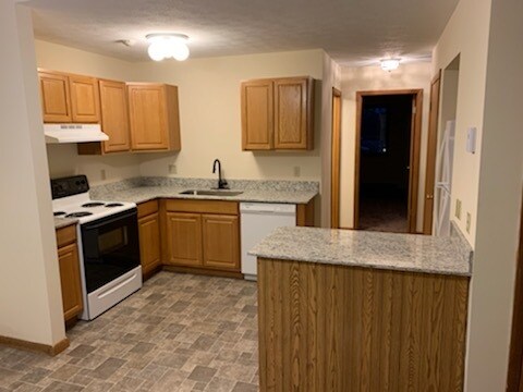
150 Old Ithaca Rd
Elmira, NY
Chemung
073489-049-003-0002-030-001-0000
New York
Apartment
30.001
2025
23.06 AC
2024
Ithaca/Elmira
010702
Other Market Areas
11,592 SF
DEMOGRAPHICS near 150 Old Ithaca Rd
1 Mile
3 Mile
5 Mile
2024 Total Population
2,831
16,032
29,008
2029 Population
2,764
15,490
28,121
Pop Growth 2024-2029
(2.37%)
(3.38%)
(3.06%)
Average Age
46
45
43
2024 Total Households
1,332
6,992
12,118
HH Growth 2024-2029
(2.18%)
(3.38%)
(3.28%)
Median Household Inc
$54,946
$64,090
$62,638
Avg Household Size
2.00
2.20
2.20
2024 Avg HH Vehicles
1.00
2.00
2.00
Median Home Value
$138,005
$159,615
$150,634
Median Year Built
1972
1968
1961
Nearby Places
Map Layers
Map Styles
 Street
 Aerial
- Restaurants
- Banks
- Shops
- Fitness
- Groceries
PUBLIC TRANSPORTATION
AIRPORT
Elmira/Corning Regional
DRIVE
WALK
Distance
Elmira/Corning Regional
13 min
7.0 mi
Ithaca Tompkins International
DRIVE
WALK
Distance
Ithaca Tompkins International
46 min
32.0 mi
Freight Ports
Albany, NY Port
DRIVE
WALK
Distance
Albany, NY Port
239 min
199.9 mi
Nearby Properties
Address
Land Use
TOTAL SIZE
Lot Size
Zoning
Address
Land Use
TOTAL SIZE
Lot Size
Zoning
464,844 SF
180.98 AC
VH08
Address
Land Use
TOTAL SIZE
Lot Size
Zoning
150,280 SF
14.32 AC
VH08
Address
Land Use
TOTAL SIZE
Lot Size
Zoning
60,899 SF
207.30 AC
TH02
Address
Land Use
TOTAL SIZE
Lot Size
Zoning
9,600 SF
87 AC
VH08
Address
Land Use
TOTAL SIZE
Lot Size
Zoning
213,707 SF
21.34 AC
TH08
Address
Land Use
TOTAL SIZE
Lot Size
Zoning
53,096 SF
10.32 AC
TH08
Address
Land Use
TOTAL SIZE
Lot Size
Zoning
1,568 SF
51.28 AC
06 - INDUS
Address
Land Use
TOTAL SIZE
Lot Size
Zoning
21.68 AC
02 - SINGL
Address
Land Use
TOTAL SIZE
Lot Size
Zoning
13,612 SF
15.30 AC
VH05
Address
Land Use
TOTAL SIZE
Lot Size
Zoning
183,919 SF
40.70 AC
TH02
Address
Land Use
TOTAL SIZE
Lot Size
Zoning
55,376 SF
32.80 AC
VH02
Address
Land Use
TOTAL SIZE
Lot Size
Zoning
6,368 SF
11.74 AC
Address
Land Use
TOTAL SIZE
Lot Size
Zoning
7,203 SF
5.10 AC
06 - INDUS
Address
Land Use
TOTAL SIZE
Lot Size
Zoning
9,072 SF
7.13 AC
VH04
Address
Land Use
TOTAL SIZE
Lot Size
Zoning
51,280 SF
6.44 AC
TH08
Address
Land Use
TOTAL SIZE
Lot Size
Zoning
63,178 SF
3.32 AC
05 - COMME
Address
Land Use
TOTAL SIZE
Lot Size
Zoning
248,126 SF
20.60 AC
VH05
Address
Land Use
TOTAL SIZE
Lot Size
Zoning
420,041 SF
46.55 AC
VH08
Address
Land Use
TOTAL SIZE
Lot Size
Zoning
66,514 SF
10.90 AC
VH10
Address
Land Use
TOTAL SIZE
Lot Size
Zoning
95,966 SF
6.82 AC
TH05
Address
Land Use
TOTAL SIZE
Lot Size
Zoning
13,468 SF
4.07 AC
TH04
Address
Land Use
TOTAL SIZE
Lot Size
Zoning
100,493 SF
29.47 AC
VH08
Address
Land Use
TOTAL SIZE
Lot Size
Zoning
54,664 SF
5.14 AC
TH08
Address
Land Use
TOTAL SIZE
Lot Size
Zoning
411,352 SF
12.39 AC
VH08
Address
Land Use
TOTAL SIZE
Lot Size
Zoning
16,896 SF
15.08 AC
06
Address
Land Use
TOTAL SIZE
Lot Size
Zoning
7,632 SF
0.71 AC
02
Address
Land Use
TOTAL SIZE
Lot Size
Zoning
53,340 SF
05 - COMME
Address
Land Use
TOTAL SIZE
Lot Size
Zoning
81,331 SF
7.44 AC
TH08
Address
Land Use
TOTAL SIZE
Lot Size
Zoning
64,054 SF
2.82 AC
05 - COMME
Address
Land Use
TOTAL SIZE
Lot Size
Zoning
79.20 AC
The World's #1 Commercial Real Estate Marketplace
Connect with us
© 2025 CoStar Group
The information above has been obtained from sources believed reliable. While we do not doubt its accuracy we have not verified it and make no guarantee, warranty or representation about it. It is your responsibility to independently confirm its accuracy and completeness. Any projections, opinions, assumptions, or estimates used are for example only and do not represent the current or future performance of the property. The value of this transaction to you depends on tax and other factors which should be evaluated by your tax, financial, and legal advisors. You and your advisors should conduct a careful, independent investigation of the property to determine to your satisfaction the suitability of the property for your needs.