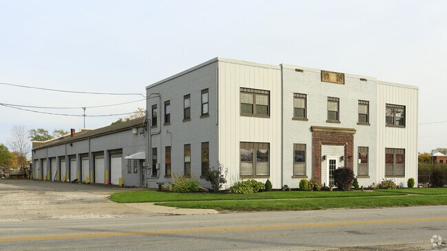
Property Record
150 Olive St, Elyria, OH 44035


Property Detail
150 Olive St
Cleveland-Elyria, OH
East/Black River
06-25-015-102-017
20050074858
Warehouse
Lorain
X
Ohio
39093C0227D
15
2024
1.52 AC
2024
Lorain/Avon Lake
070700
Cleveland
19,056 SF
NEARBY LISTINGS FOR SALE OR LEASE
DEMOGRAPHICS near 150 Olive St
1 mile
3 mile
5 mile
2024 Total Population
10,602
61,676
105,711
2029 Population
11,041
64,270
110,091
Pop Growth 2024-2029
+ 4.14%
+ 4.21%
+ 4.14%
Average Age
40
41
42
2024 Total Households
4,679
26,120
44,183
HH Growth 2024-2029
+ 4.08%
+ 4.15%
+ 4.11%
Median Household Inc
$53,726
$53,223
$57,140
Avg Household Size
2.20
2.30
2.30
2024 Avg HH Vehicles
2.00
2.00
2.00
Median Home Value
$99,864
$148,206
$163,521
Median Year Built
1953
1965
1970
Nearby Places
Map Layers
Map Styles
 Street
 Aerial
Transit
 Traffic
 Biking
Places
Listings with unknown addresses are not visible on the map
- Restaurants
- Banks
- Shops
- Fitness
- Groceries
PUBLIC TRANSPORTATION
COMMUTER RAIL
Elyria Amtrak (Capitol Limited - Amtrak, Lake Shore Limited - Amtrak)
Drive
Walk
Distance
Elyria Amtrak (Capitol Limited - Amtrak, Lake Shore Limited - Amtrak)
2 min
15 min
0.8 mi
AIRPORT
Cleveland-Hopkins International
Drive
Walk
Distance
Cleveland-Hopkins International
27 min
18.8 mi
Freight Ports
Port of Toledo
Drive
Walk
Distance
Port of Toledo
110 min
90.5 mi
Nearby Properties
Address
Land Use
TOTAL SIZE
Lot Size
Zoning
Address
Land Use
TOTAL SIZE
Lot Size
Zoning
908,481 SF
48.80 AC
Address
Land Use
TOTAL SIZE
Lot Size
Zoning
427,871 SF
6.24 AC
Address
Land Use
TOTAL SIZE
Lot Size
Zoning
351,623 SF
3.13 AC
Address
Land Use
TOTAL SIZE
Lot Size
Zoning
199,200 SF
1.77 AC
Address
Land Use
TOTAL SIZE
Lot Size
Zoning
264,274 SF
15.03 AC
Address
Land Use
TOTAL SIZE
Lot Size
Zoning
128,869 SF
30.06 AC
Address
Land Use
TOTAL SIZE
Lot Size
Zoning
50,761 SF
46.25 AC
Address
Land Use
TOTAL SIZE
Lot Size
Zoning
129,277 SF
17.35 AC
Address
Land Use
TOTAL SIZE
Lot Size
Zoning
61,570 SF
0.20 AC
Address
Land Use
TOTAL SIZE
Lot Size
Zoning
150,180 SF
20.21 AC
Address
Land Use
TOTAL SIZE
Lot Size
Zoning
346,114 SF
37.97 AC
Address
Land Use
TOTAL SIZE
Lot Size
Zoning
46,764 SF
2.98 AC
Address
Land Use
TOTAL SIZE
Lot Size
Zoning
115,734 SF
29.86 AC
Address
Land Use
TOTAL SIZE
Lot Size
Zoning
107,576 SF
14.79 AC
Address
Land Use
TOTAL SIZE
Lot Size
Zoning
10,608 SF
76.77 AC
Address
Land Use
TOTAL SIZE
Lot Size
Zoning
206,128 SF
19.97 AC
Address
Land Use
TOTAL SIZE
Lot Size
Zoning
79,556 SF
17.55 AC
Address
Land Use
TOTAL SIZE
Lot Size
Zoning
106,938 SF
1.12 AC
Address
Land Use
TOTAL SIZE
Lot Size
Zoning
32,784 SF
0.25 AC
Address
Land Use
TOTAL SIZE
Lot Size
Zoning
126,448 SF
22.54 AC
Address
Land Use
TOTAL SIZE
Lot Size
Zoning
115,898 SF
8.67 AC
Address
Land Use
TOTAL SIZE
Lot Size
Zoning
158,510 SF
6.01 AC
Address
Land Use
TOTAL SIZE
Lot Size
Zoning
169,280 SF
15.56 AC
Address
Land Use
TOTAL SIZE
Lot Size
Zoning
61,278 SF
8.25 AC
Address
Land Use
TOTAL SIZE
Lot Size
Zoning
40,000 SF
4.20 AC
Address
Land Use
TOTAL SIZE
Lot Size
Zoning
57,634 SF
4.73 AC
Address
Land Use
TOTAL SIZE
Lot Size
Zoning
56.71 AC
Address
Land Use
TOTAL SIZE
Lot Size
Zoning
971,475 SF
54.21 AC
Address
Land Use
TOTAL SIZE
Lot Size
Zoning
151,565 SF
0.11 AC
Address
Land Use
TOTAL SIZE
Lot Size
Zoning
39,249 SF
0.74 AC
The World's #1 Commercial Real Estate Marketplace
Connect with us
© 2026 CoStar Group
The information above has been obtained from sources believed reliable. While we do not doubt its accuracy we have not verified it and make no guarantee, warranty or representation about it. It is your responsibility to independently confirm its accuracy and completeness. Any projections, opinions, assumptions, or estimates used are for example only and do not represent the current or future performance of the property. The value of this transaction to you depends on tax and other factors which should be evaluated by your tax, financial, and legal advisors. You and your advisors should conduct a careful, independent investigation of the property to determine to your satisfaction the suitability of the property for your needs.