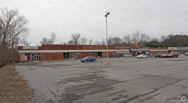
Property Record
150 Park Lane Dr, Rutherfordton, NC 28139


Current Lease Availabilities
NEARBY LISTINGS FOR SALE OR LEASE
Property Detail
150 Park Lane Dr
1206161
GPIN:1610208086240000; BLDGS CHARLOTTE RD
Laundromat
Rutherford
AE
North Carolina
3710161000J
5.70 AC
2025
North Carolina West/Cherokee Area
2025
Other Market Areas
960503
Forest City, NC
2,880 SF
DEMOGRAPHICS near 150 Park Lane Dr
1 Mile
3 Mile
5 Mile
2024 Total Population
2,903
12,565
21,466
2029 Population
2,989
12,889
21,901
Pop Growth 2024-2029
+ 2.96%
+ 2.58%
+ 2.03%
Average Age
43
43
43
2024 Total Households
1,261
5,130
8,807
HH Growth 2024-2029
+ 2.85%
+ 2.50%
+ 1.91%
Median Household Inc
$30,587
$37,822
$40,116
Avg Household Size
2.20
2.30
2.30
2024 Avg HH Vehicles
2.00
2.00
2.00
Median Home Value
$165,312
$158,347
$158,099
Median Year Built
1977
1974
1976
Nearby Places
Map Layers
Map Styles
 Street
 Aerial
- Restaurants
- Banks
- Shops
- Fitness
- Groceries
PUBLIC TRANSPORTATION
AIRPORT
Asheville Regional
DRIVE
WALK
Distance
Asheville Regional
59 min
48.9 mi
Nearby Properties
Address
Land Use
TOTAL SIZE
Lot Size
Zoning
Address
Land Use
TOTAL SIZE
Lot Size
Zoning
334,081 SF
94.10 AC
Address
Land Use
TOTAL SIZE
Lot Size
Zoning
168,615 SF
27.34 AC
CIV
Address
Land Use
TOTAL SIZE
Lot Size
Zoning
29,884 SF
54.60 AC
Address
Land Use
TOTAL SIZE
Lot Size
Zoning
141,217 SF
27.03 AC
Address
Land Use
TOTAL SIZE
Lot Size
Zoning
87,123 SF
1.98 AC
Address
Land Use
TOTAL SIZE
Lot Size
Zoning
421,200 SF
41.90 AC
Address
Land Use
TOTAL SIZE
Lot Size
Zoning
61,023 SF
7.64 AC
R6
Address
Land Use
TOTAL SIZE
Lot Size
Zoning
1,408 SF
6.95 AC
R20
Address
Land Use
TOTAL SIZE
Lot Size
Zoning
4,982 SF
27.13 AC
Address
Land Use
TOTAL SIZE
Lot Size
Zoning
2,026 SF
8.71 AC
R6
Address
Land Use
TOTAL SIZE
Lot Size
Zoning
210,000 SF
54.75 AC
Address
Land Use
TOTAL SIZE
Lot Size
Zoning
95,267 SF
8.40 AC
GC
Address
Land Use
TOTAL SIZE
Lot Size
Zoning
16,074 SF
101.60 AC
Address
Land Use
TOTAL SIZE
Lot Size
Zoning
7,424 SF
6.39 AC
IND
Address
Land Use
TOTAL SIZE
Lot Size
Zoning
53,790 SF
6.37 AC
R6
Address
Land Use
TOTAL SIZE
Lot Size
Zoning
6,448 SF
3.30 AC
GC
Address
Land Use
TOTAL SIZE
Lot Size
Zoning
6,000 SF
15.30 AC
Address
Land Use
TOTAL SIZE
Lot Size
Zoning
6,988 SF
1.51 AC
R6
Address
Land Use
TOTAL SIZE
Lot Size
Zoning
10,366 SF
1.22 AC
CIV
Address
Land Use
TOTAL SIZE
Lot Size
Zoning
19,530 SF
1.50 AC
CIV
Address
Land Use
TOTAL SIZE
Lot Size
Zoning
34,861 SF
4.38 AC
CIV
Address
Land Use
TOTAL SIZE
Lot Size
Zoning
93,600 SF
45.11 AC
HCI
Address
Land Use
TOTAL SIZE
Lot Size
Zoning
17,622 SF
5.14 AC
MS
Address
Land Use
TOTAL SIZE
Lot Size
Zoning
53,860 SF
15.88 AC
CIV
Address
Land Use
TOTAL SIZE
Lot Size
Zoning
7,367 SF
0.64 AC
CIV
Address
Land Use
TOTAL SIZE
Lot Size
Zoning
42,360 SF
CIV
Address
Land Use
TOTAL SIZE
Lot Size
Zoning
1,200 SF
6.13 AC
SFR-3
Address
Land Use
TOTAL SIZE
Lot Size
Zoning
68,755 SF
11.73 AC
IND
Address
Land Use
TOTAL SIZE
Lot Size
Zoning
42,480 SF
3.90 AC
CIV
Address
Land Use
TOTAL SIZE
Lot Size
Zoning
27,402 SF
0.09 AC
C1
The World's #1 Commercial Real Estate Marketplace
Connect with us
© 2025 CoStar Group
The information above has been obtained from sources believed reliable. While we do not doubt its accuracy we have not verified it and make no guarantee, warranty or representation about it. It is your responsibility to independently confirm its accuracy and completeness. Any projections, opinions, assumptions, or estimates used are for example only and do not represent the current or future performance of the property. The value of this transaction to you depends on tax and other factors which should be evaluated by your tax, financial, and legal advisors. You and your advisors should conduct a careful, independent investigation of the property to determine to your satisfaction the suitability of the property for your needs.