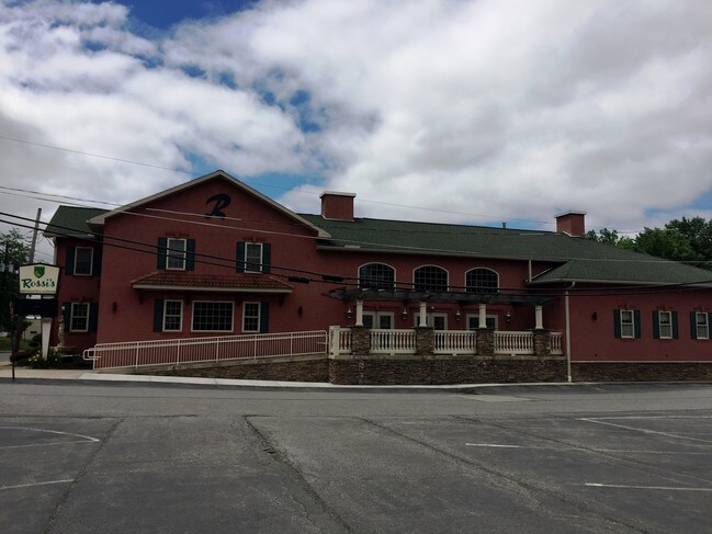
Property Record
150 S Main St, Archbald, PA 18403
NEARBY LISTINGS FOR SALE OR LEASE
Property Detail
150 S Main St
Scranton--Wilkes-Barre--Hazelton, PA
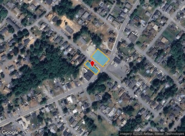
Map Of Jones Simpson
10412020004
50X150X101X150X100X150 BLDG & LAND W-01 B-4190 L-1500 P-
Taxexempt
Lackawanna
X
Pennsylvania
42069C0231D
1500
2025
0.52 AC
2025
I-81 Corridor
111100
Philadelphia
DEMOGRAPHICS near 150 S Main St
1 Mile
3 Mile
5 Mile
2024 Total Population
5,182
22,688
40,327
2029 Population
5,119
22,314
39,865
Pop Growth 2024-2029
(1.22%)
(1.65%)
(1.15%)
Average Age
43
43
43
2024 Total Households
2,133
9,833
17,498
HH Growth 2024-2029
(1.22%)
(1.65%)
(1.15%)
Median Household Inc
$63,913
$59,322
$62,581
Avg Household Size
2.40
2.30
2.30
2024 Avg HH Vehicles
2.00
2.00
2.00
Median Home Value
$188,269
$165,555
$169,654
Median Year Built
1961
1952
1953
Nearby Places
Map Layers
Map Styles
 Street
 Aerial
- Restaurants
- Banks
- Shops
- Fitness
- Groceries
PUBLIC TRANSPORTATION
AIRPORT
Wilkes-Barre/Scranton International
DRIVE
WALK
Distance
Wilkes-Barre/Scranton International
28 min
17.5 mi
Freight Ports
Maher Terminal
DRIVE
WALK
Distance
Maher Terminal
150 min
118.6 mi
SALE & LEASE HISTORY
LISTING DATE
SALE/LEASE

Sep 24, 2016
For Sale
Oct 07, 2024
For Sale
Aug 13, 2018
For Lease
Nearby Properties
Address
Land Use
TOTAL SIZE
Lot Size
Zoning
Address
Land Use
TOTAL SIZE
Lot Size
Zoning
65.35 AC
Address
Land Use
TOTAL SIZE
Lot Size
Zoning
112.27 AC
Address
Land Use
TOTAL SIZE
Lot Size
Zoning
92.02 AC
Address
Land Use
TOTAL SIZE
Lot Size
Zoning
70.21 AC
Address
Land Use
TOTAL SIZE
Lot Size
Zoning
26.40 AC
Address
Land Use
TOTAL SIZE
Lot Size
Zoning
59.07 AC
Address
Land Use
TOTAL SIZE
Lot Size
Zoning
43.89 AC
Address
Land Use
TOTAL SIZE
Lot Size
Zoning
6.89 AC
Address
Land Use
TOTAL SIZE
Lot Size
Zoning
135.22 AC
Address
Land Use
TOTAL SIZE
Lot Size
Zoning
14.57 AC
Address
Land Use
TOTAL SIZE
Lot Size
Zoning
38.12 AC
Address
Land Use
TOTAL SIZE
Lot Size
Zoning
29.58 AC
Address
Land Use
TOTAL SIZE
Lot Size
Zoning
99.18 AC
Address
Land Use
TOTAL SIZE
Lot Size
Zoning
10.10 AC
Address
Land Use
TOTAL SIZE
Lot Size
Zoning
30.06 AC
Address
Land Use
TOTAL SIZE
Lot Size
Zoning
197.82 AC
Address
Land Use
TOTAL SIZE
Lot Size
Zoning
7.30 AC
Address
Land Use
TOTAL SIZE
Lot Size
Zoning
44.05 AC
Address
Land Use
TOTAL SIZE
Lot Size
Zoning
27.39 AC
Address
Land Use
TOTAL SIZE
Lot Size
Zoning
4.96 AC
Address
Land Use
TOTAL SIZE
Lot Size
Zoning
18.30 AC
Address
Land Use
TOTAL SIZE
Lot Size
Zoning
10.59 AC
Address
Land Use
TOTAL SIZE
Lot Size
Zoning
5.35 AC
Address
Land Use
TOTAL SIZE
Lot Size
Zoning
10.34 AC
Address
Land Use
TOTAL SIZE
Lot Size
Zoning
14.41 AC
Address
Land Use
TOTAL SIZE
Lot Size
Zoning
10.38 AC
Address
Land Use
TOTAL SIZE
Lot Size
Zoning
18.61 AC
Address
Land Use
TOTAL SIZE
Lot Size
Zoning
1.80 AC
Address
Land Use
TOTAL SIZE
Lot Size
Zoning
2,428 SF
357.58 AC
Address
Land Use
TOTAL SIZE
Lot Size
Zoning
13.64 AC
The World's #1 Commercial Real Estate Marketplace
Connect with us
© 2025 CoStar Group
The information above has been obtained from sources believed reliable. While we do not doubt its accuracy we have not verified it and make no guarantee, warranty or representation about it. It is your responsibility to independently confirm its accuracy and completeness. Any projections, opinions, assumptions, or estimates used are for example only and do not represent the current or future performance of the property. The value of this transaction to you depends on tax and other factors which should be evaluated by your tax, financial, and legal advisors. You and your advisors should conduct a careful, independent investigation of the property to determine to your satisfaction the suitability of the property for your needs.