Property Record
150 Stedman St, Chelmsford, MA 01824
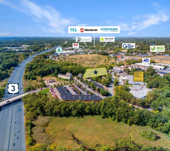
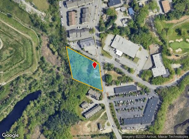
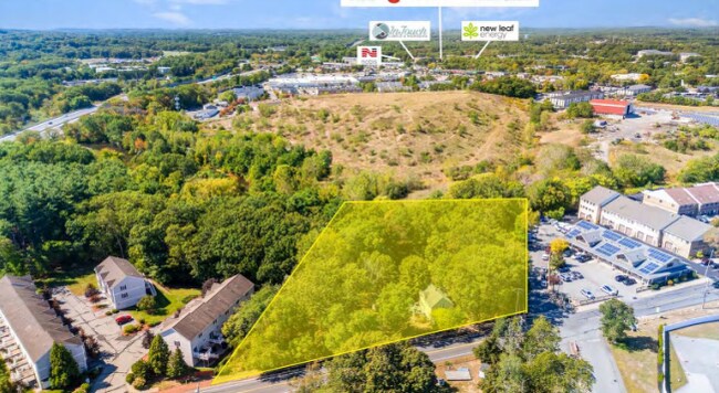
This Property Is For Sale
NEARBY LISTINGS FOR SALE OR LEASE
Property Detail
150 Stedman St
Boston-Cambridge-Newton, MA-NH
Middlesex
CHEL-000033-000110-000001
Massachusetts
Sfr
1.90 AC
X
Lowell/Chelmsford
25017C0251G
Boston
1,056 SF
DEMOGRAPHICS near 150 Stedman St
1 Mile
3 Mile
5 Mile
2024 Total Population
12,259
118,088
212,472
2029 Population
12,723
121,930
219,728
Pop Growth 2024-2029
+ 3.78%
+ 3.25%
+ 3.42%
Average Age
40
39
40
2024 Total Households
4,567
42,991
77,709
HH Growth 2024-2029
+ 3.88%
+ 3.51%
+ 3.62%
Median Household Inc
$102,553
$90,058
$98,037
Avg Household Size
2.50
2.50
2.60
2024 Avg HH Vehicles
2.00
2.00
2.00
Median Home Value
$570,388
$479,456
$510,401
Median Year Built
1967
1960
1964
Nearby Places
- Restaurants
- Banks
- Shops
- Fitness
- Groceries
PUBLIC TRANSPORTATION
COMMUTER RAIL
Lowell (Lowell Line - Massachusetts Bay Transportation Authority Commuter Rail (Purple Line))
DRIVE
WALK
Distance
Lowell (Lowell Line - Massachusetts Bay Transportation Authority Commuter Rail (Purple Line))
5 min
2.5 mi
North Billerica (Lowell Line - Massachusetts Bay Transportation Authority Commuter Rail (Purple Line))
DRIVE
WALK
Distance
North Billerica (Lowell Line - Massachusetts Bay Transportation Authority Commuter Rail (Purple Line))
10 min
6.5 mi
AIRPORT
Manchester Boston Regional
DRIVE
WALK
Distance
Manchester Boston Regional
42 min
28.8 mi
General Edward Lawrence Logan International
DRIVE
WALK
Distance
General Edward Lawrence Logan International
47 min
35.8 mi
Freight Ports
Port of Boston
DRIVE
WALK
Distance
Port of Boston
48 min
35.5 mi
Nearby Properties
Address
Land Use
TOTAL SIZE
Lot Size
Zoning
Address
Land Use
TOTAL SIZE
Lot Size
Zoning
9.73 AC
INST
Address
Land Use
TOTAL SIZE
Lot Size
Zoning
14.73 AC
HRC
Address
Land Use
TOTAL SIZE
Lot Size
Zoning
30,744 SF
31.28 AC
INST
Address
Land Use
TOTAL SIZE
Lot Size
Zoning
23,251 SF
18.20 AC
SMF
Address
Land Use
TOTAL SIZE
Lot Size
Zoning
275,574 SF
6.66 AC
HRCO
Address
Land Use
TOTAL SIZE
Lot Size
Zoning
224,076 SF
1.15 AC
HCD
Address
Land Use
TOTAL SIZE
Lot Size
Zoning
215,884 SF
1.55 AC
DMU
Address
Land Use
TOTAL SIZE
Lot Size
Zoning
134,439 SF
3.29 AC
DMU
Address
Land Use
TOTAL SIZE
Lot Size
Zoning
6.30 AC
UMU
Address
Land Use
TOTAL SIZE
Lot Size
Zoning
11.45 AC
TTF
Address
Land Use
TOTAL SIZE
Lot Size
Zoning
2.15 AC
INST
Address
Land Use
TOTAL SIZE
Lot Size
Zoning
15.16 AC
SMF
Address
Land Use
TOTAL SIZE
Lot Size
Zoning
174 SF
IA
Address
Land Use
TOTAL SIZE
Lot Size
Zoning
19.97 AC
SSF
Address
Land Use
TOTAL SIZE
Lot Size
Zoning
59.09 AC
SSF
Address
Land Use
TOTAL SIZE
Lot Size
Zoning
6.27 AC
DMU
Address
Land Use
TOTAL SIZE
Lot Size
Zoning
225,252 SF
2.31 AC
DMU
Address
Land Use
TOTAL SIZE
Lot Size
Zoning
269,952 SF
18.11 AC
P
Address
Land Use
TOTAL SIZE
Lot Size
Zoning
68.15 AC
R1
Address
Land Use
TOTAL SIZE
Lot Size
Zoning
262,607 SF
4.33 AC
INST
Address
Land Use
TOTAL SIZE
Lot Size
Zoning
10.48 AC
INST
Address
Land Use
TOTAL SIZE
Lot Size
Zoning
7.18 AC
SMF
Address
Land Use
TOTAL SIZE
Lot Size
Zoning
168,114 SF
0.17 AC
UMU
Address
Land Use
TOTAL SIZE
Lot Size
Zoning
38.26 AC
P
Address
Land Use
TOTAL SIZE
Lot Size
Zoning
2.62 AC
INST
Address
Land Use
TOTAL SIZE
Lot Size
Zoning
26.65 AC
IA
Address
Land Use
TOTAL SIZE
Lot Size
Zoning
7.41 AC
CB
Address
Land Use
TOTAL SIZE
Lot Size
Zoning
7.25 AC
INST
Address
Land Use
TOTAL SIZE
Lot Size
Zoning
167,201 SF
6.31 AC
DMU
Address
Land Use
TOTAL SIZE
Lot Size
Zoning
185,172 SF
2.93 AC
DMU
The World's #1 Commercial Real Estate Marketplace
Connect with us
© 2025 CoStar Group
The information above has been obtained from sources believed reliable. While we do not doubt its accuracy we have not verified it and make no guarantee, warranty or representation about it. It is your responsibility to independently confirm its accuracy and completeness. Any projections, opinions, assumptions, or estimates used are for example only and do not represent the current or future performance of the property. The value of this transaction to you depends on tax and other factors which should be evaluated by your tax, financial, and legal advisors. You and your advisors should conduct a careful, independent investigation of the property to determine to your satisfaction the suitability of the property for your needs.