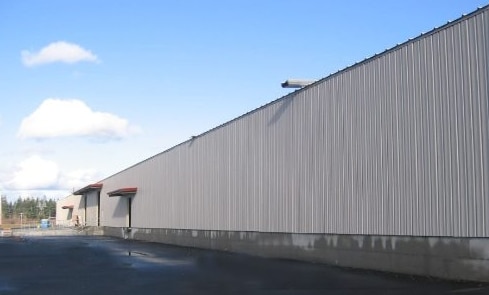
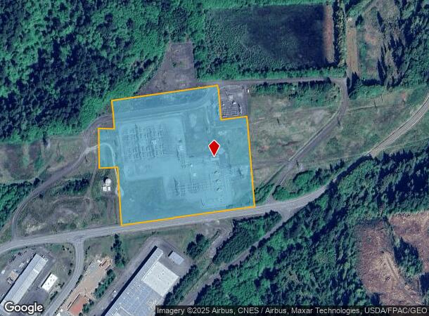
Property Record
487 Lambert Rd, Elma, WA 98541
NEARBY LISTINGS FOR SALE OR LEASE
Property Detail
487 Lambert Rd
170608340010
TAX 2
Utilities
Grays Harbor
X
Washington
53027C0980E
340
0
15.60 AC
2025
Other Market Areas
000501
Aberdeen, WA
DEMOGRAPHICS near 487 Lambert Rd
1 mile
3 mile
5 mile
2024 Total Population
42
1,208
6,964
2029 Population
45
1,263
7,241
Pop Growth 2024-2029
+ 7.14%
+ 4.55%
+ 3.98%
Average Age
44
41
41
2024 Total Households
16
438
2,623
HH Growth 2024-2029
+ 12.50%
+ 4.79%
+ 4.00%
Median Household Inc
$74,999
$63,461
$70,611
Avg Household Size
2.30
2.60
2.60
2024 Avg HH Vehicles
3.00
2.00
2.00
Median Home Value
$410,000
$350,574
$331,151
Median Year Built
1982
1984
1976
Nearby Places
Map Layers
Map Styles
 Street
 Aerial
Transit
 Traffic
 Biking
Places
Listings with unknown addresses are not visible on the map
- Restaurants
- Banks
- Shops
- Fitness
- Groceries
Nearby Properties
Address
Land Use
TOTAL SIZE
Lot Size
Zoning
Address
Land Use
TOTAL SIZE
Lot Size
Zoning
468,765 SF
374.02 AC
G5
Address
Land Use
TOTAL SIZE
Lot Size
Zoning
57,643 SF
24.41 AC
G5
Address
Land Use
TOTAL SIZE
Lot Size
Zoning
69,240 SF
45.79 AC
RR
Address
Land Use
TOTAL SIZE
Lot Size
Zoning
150,000 SF
16.70 AC
G5
Address
Land Use
TOTAL SIZE
Lot Size
Zoning
106,280 SF
10.50 AC
Address
Land Use
TOTAL SIZE
Lot Size
Zoning
114,600 SF
232.17 AC
G5
Address
Land Use
TOTAL SIZE
Lot Size
Zoning
6.36 AC
Address
Land Use
TOTAL SIZE
Lot Size
Zoning
46,960 SF
3.31 AC
RR
Address
Land Use
TOTAL SIZE
Lot Size
Zoning
14.71 AC
R2
Address
Land Use
TOTAL SIZE
Lot Size
Zoning
34,148 SF
7.36 AC
Address
Land Use
TOTAL SIZE
Lot Size
Zoning
15,848 SF
5.66 AC
Address
Land Use
TOTAL SIZE
Lot Size
Zoning
1,912 SF
257.28 AC
G5
Address
Land Use
TOTAL SIZE
Lot Size
Zoning
16,224 SF
22.57 AC
SD
Address
Land Use
TOTAL SIZE
Lot Size
Zoning
25,310 SF
0.27 AC
SD
Address
Land Use
TOTAL SIZE
Lot Size
Zoning
12,000 SF
2.99 AC
I2
Address
Land Use
TOTAL SIZE
Lot Size
Zoning
5.58 AC
RR
Address
Land Use
TOTAL SIZE
Lot Size
Zoning
1,440 SF
6.83 AC
R2
Address
Land Use
TOTAL SIZE
Lot Size
Zoning
21,415 SF
71.47 AC
A2
Address
Land Use
TOTAL SIZE
Lot Size
Zoning
6,400 SF
2.27 AC
A2
Address
Land Use
TOTAL SIZE
Lot Size
Zoning
18,380 SF
3.34 AC
I2
Address
Land Use
TOTAL SIZE
Lot Size
Zoning
4,608 SF
87.86 AC
RR
Address
Land Use
TOTAL SIZE
Lot Size
Zoning
6,238 SF
2.96 AC
G5
Address
Land Use
TOTAL SIZE
Lot Size
Zoning
7,098 SF
0.92 AC
Address
Land Use
TOTAL SIZE
Lot Size
Zoning
2,244 SF
120.85 AC
A2
Address
Land Use
TOTAL SIZE
Lot Size
Zoning
18,396 SF
37.05 AC
A1
Address
Land Use
TOTAL SIZE
Lot Size
Zoning
5,456 SF
1.77 AC
C1
Address
Land Use
TOTAL SIZE
Lot Size
Zoning
8,355 SF
1.65 AC
C1
Address
Land Use
TOTAL SIZE
Lot Size
Zoning
3,650 SF
13.60 AC
Address
Land Use
TOTAL SIZE
Lot Size
Zoning
3,752 SF
2.87 AC
RR
The World's #1 Commercial Real Estate Marketplace
Connect with us
© 2026 CoStar Group
The information above has been obtained from sources believed reliable. While we do not doubt its accuracy we have not verified it and make no guarantee, warranty or representation about it. It is your responsibility to independently confirm its accuracy and completeness. Any projections, opinions, assumptions, or estimates used are for example only and do not represent the current or future performance of the property. The value of this transaction to you depends on tax and other factors which should be evaluated by your tax, financial, and legal advisors. You and your advisors should conduct a careful, independent investigation of the property to determine to your satisfaction the suitability of the property for your needs.