Property Record
150 W Main St, Naturita, CO 81422
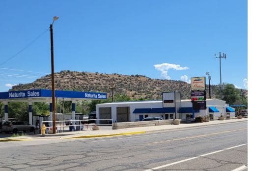

Property Detail
150 W Main St
R0651552
SUBD: GRIPE SUBD BLOCK: 1 LOT: 11 THRU:- LOT: 21 S: 30 T: 46 R: 15
Conveniencestore
Montrose
B and X Area of moderate flood hazard, usually the area between the limits of the 100-year and 500-year floods.
Colorado
2025
0.76 AC
2025
Colorado Southwest Area
966100
Other Market Areas
2,547 SF
Montrose, CO
NEARBY LISTINGS FOR SALE OR LEASE
-
-
View all Naturita listings for sale on LoopNet.com
DEMOGRAPHICS near 150 W Main St
1 mile
3 mile
5 mile
2025 Total Population
427
612
1,409
2030 Population
444
633
1,436
Pop Growth 2025-2030
+ 3.98%
+ 3.43%
+ 1.92%
Average Age
47
47
47
2025 Total Households
195
281
653
HH Growth 2025-2030
+ 4.10%
+ 3.56%
+ 2.14%
Median Household Inc
$33,749
$35,937
$38,571
Avg Household Size
2.20
2.20
2.20
2025 Avg HH Vehicles
2.00
2.00
2.00
Median Home Value
$191,269
$195,929
$218,657
Median Year Built
1973
1972
1971
Nearby Places
Map Layers
Map Styles
 Street
 Aerial
Layers
 Traffic
 Biking
Places
Listings with unknown addresses are not visible on the map
- Restaurants
- Banks
- Shops
- Fitness
- Groceries
SALE & LEASE HISTORY
LISTING DATE
SALE/LEASE

Oct 24, 2022
For Sale
Nearby Properties
Address
Land Use
TOTAL SIZE
Lot Size
Zoning
Address
Land Use
TOTAL SIZE
Lot Size
Zoning
2,404 SF
725.62 AC
Address
Land Use
TOTAL SIZE
Lot Size
Zoning
8,412 SF
0.76 AC
Address
Land Use
TOTAL SIZE
Lot Size
Zoning
8,530 SF
1.62 AC
Address
Land Use
TOTAL SIZE
Lot Size
Zoning
11,940 SF
0.46 AC
Address
Land Use
TOTAL SIZE
Lot Size
Zoning
4,556 SF
0.28 AC
Address
Land Use
TOTAL SIZE
Lot Size
Zoning
17,758 SF
9.05 AC
Address
Land Use
TOTAL SIZE
Lot Size
Zoning
4,880 SF
7.84 AC
Address
Land Use
TOTAL SIZE
Lot Size
Zoning
2,430 SF
1.17 AC
Address
Land Use
TOTAL SIZE
Lot Size
Zoning
7,200 SF
13.80 AC
Address
Land Use
TOTAL SIZE
Lot Size
Zoning
3,000 SF
4.83 AC
Address
Land Use
TOTAL SIZE
Lot Size
Zoning
2,364 SF
40 AC
Address
Land Use
TOTAL SIZE
Lot Size
Zoning
6,000 SF
10 AC
Address
Land Use
TOTAL SIZE
Lot Size
Zoning
4,000 SF
1.90 AC
Address
Land Use
TOTAL SIZE
Lot Size
Zoning
995 SF
1.64 AC
Address
Land Use
TOTAL SIZE
Lot Size
Zoning
4,063 SF
2.79 AC
Address
Land Use
TOTAL SIZE
Lot Size
Zoning
8,700 SF
5.37 AC
Address
Land Use
TOTAL SIZE
Lot Size
Zoning
4,840 SF
8.25 AC
Address
Land Use
TOTAL SIZE
Lot Size
Zoning
1,560 SF
0.07 AC
Address
Land Use
TOTAL SIZE
Lot Size
Zoning
4,000 SF
2.90 AC
Address
Land Use
TOTAL SIZE
Lot Size
Zoning
4,500 SF
0.10 AC
Address
Land Use
TOTAL SIZE
Lot Size
Zoning
8,880 SF
2.93 AC
Address
Land Use
TOTAL SIZE
Lot Size
Zoning
4,990 SF
Address
Land Use
TOTAL SIZE
Lot Size
Zoning
4,102 SF
6.27 AC
Address
Land Use
TOTAL SIZE
Lot Size
Zoning
6,134 SF
0.33 AC
Address
Land Use
TOTAL SIZE
Lot Size
Zoning
4,000 SF
1.22 AC
Address
Land Use
TOTAL SIZE
Lot Size
Zoning
12,240 SF
7.37 AC
Address
Land Use
TOTAL SIZE
Lot Size
Zoning
2,968 SF
0.80 AC
Address
Land Use
TOTAL SIZE
Lot Size
Zoning
4,800 SF
0.43 AC
Address
Land Use
TOTAL SIZE
Lot Size
Zoning
4,349 SF
The World's #1 Commercial Real Estate Marketplace
Connect with us
© 2026 CoStar Group
The information above has been obtained from sources believed reliable. While we do not doubt its accuracy we have not verified it and make no guarantee, warranty or representation about it. It is your responsibility to independently confirm its accuracy and completeness. Any projections, opinions, assumptions, or estimates used are for example only and do not represent the current or future performance of the property. The value of this transaction to you depends on tax and other factors which should be evaluated by your tax, financial, and legal advisors. You and your advisors should conduct a careful, independent investigation of the property to determine to your satisfaction the suitability of the property for your needs.