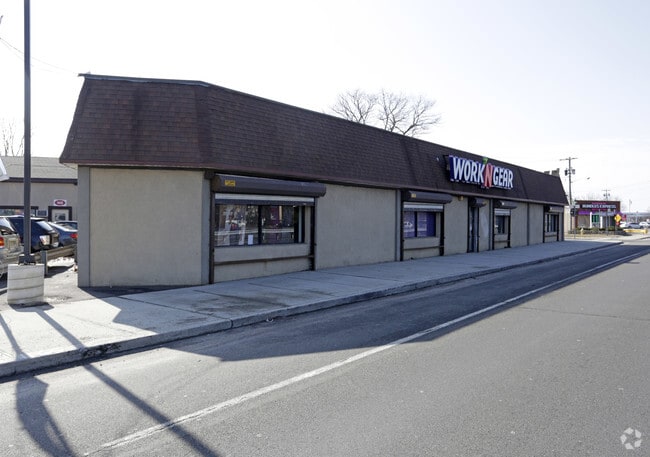
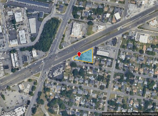
Property Record
150 W Sunrise Hwy, Lindenhurst, NY 11757
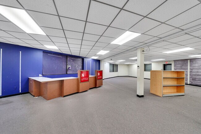
Current Lease Availabilities
NEARBY LISTINGS FOR SALE OR LEASE
Property Detail
150 W Sunrise Hwy
0103-001-00-03-00-007-002
FM 155 SEC 4 BLK 55 LT.P/O15-19,46-50 ,55ALL51-54
Commercialnec
Suffolk
X
New York
36103C0835H
7
2024
0.51 AC
2024
Southwestern Suffolk
123900
Long Island (New York)
7,567 SF
Nassau County-Suffolk County, NY
DEMOGRAPHICS near 150 W Sunrise Hwy
1 Mile
3 Mile
5 Mile
2024 Total Population
21,215
142,536
290,036
2029 Population
20,622
139,202
283,832
Pop Growth 2024-2029
(2.80%)
(2.34%)
(2.14%)
Average Age
38
41
41
2024 Total Households
6,193
47,548
96,030
HH Growth 2024-2029
(3.16%)
(2.52%)
(2.32%)
Median Household Inc
$109,887
$105,449
$116,521
Avg Household Size
3.20
2.90
2.90
2024 Avg HH Vehicles
2.00
2.00
2.00
Median Home Value
$419,854
$452,999
$487,370
Median Year Built
1960
1960
1958
Nearby Places
- Restaurants
- Banks
- Shops
- Fitness
- Groceries
PUBLIC TRANSPORTATION
COMMUTER RAIL
Copiague Station (Babylon Branch - Long Island Rail Road)
DRIVE
WALK
Distance
Copiague Station (Babylon Branch - Long Island Rail Road)
3 min
1.4 mi
Lindenhurst Station (Babylon Branch - Long Island Rail Road)
DRIVE
WALK
Distance
Lindenhurst Station (Babylon Branch - Long Island Rail Road)
3 min
1.7 mi
AIRPORT
Long Island MacArthur
DRIVE
WALK
Distance
Long Island MacArthur
26 min
19.2 mi
John F Kennedy International
DRIVE
WALK
Distance
John F Kennedy International
34 min
24.6 mi
LaGuardia
DRIVE
WALK
Distance
LaGuardia
45 min
31.6 mi
Freight Ports
NY - Red Hook Container Terminal
DRIVE
WALK
Distance
NY - Red Hook Container Terminal
55 min
36.0 mi
Nearby Properties
Address
Land Use
TOTAL SIZE
Lot Size
Zoning
Address
Land Use
TOTAL SIZE
Lot Size
Zoning
12,920 SF
1.90 AC
R60
Address
Land Use
TOTAL SIZE
Lot Size
Zoning
9.95 AC
BUS3
Address
Land Use
TOTAL SIZE
Lot Size
Zoning
892,140 SF
31.82 AC
Address
Land Use
TOTAL SIZE
Lot Size
Zoning
24.90 AC
B
Address
Land Use
TOTAL SIZE
Lot Size
Zoning
3,518 SF
0.44 AC
VILLA
Address
Land Use
TOTAL SIZE
Lot Size
Zoning
6.37 AC
BUS3
Address
Land Use
TOTAL SIZE
Lot Size
Zoning
2,520 SF
0.89 AC
HC
Address
Land Use
TOTAL SIZE
Lot Size
Zoning
1.70 AC
R40
Address
Land Use
TOTAL SIZE
Lot Size
Zoning
22.10 AC
Address
Land Use
TOTAL SIZE
Lot Size
Zoning
0.99 AC
HB
Address
Land Use
TOTAL SIZE
Lot Size
Zoning
0.90 AC
HC
Address
Land Use
TOTAL SIZE
Lot Size
Zoning
7.15 AC
Address
Land Use
TOTAL SIZE
Lot Size
Zoning
6,891 SF
0.75 AC
HC
Address
Land Use
TOTAL SIZE
Lot Size
Zoning
13.63 AC
B
Address
Land Use
TOTAL SIZE
Lot Size
Zoning
205,948 SF
15.21 AC
Address
Land Use
TOTAL SIZE
Lot Size
Zoning
Address
Land Use
TOTAL SIZE
Lot Size
Zoning
44 AC
E
Address
Land Use
TOTAL SIZE
Lot Size
Zoning
9.68 AC
SC
Address
Land Use
TOTAL SIZE
Lot Size
Zoning
3.80 AC
BUS1
Address
Land Use
TOTAL SIZE
Lot Size
Zoning
74.90 AC
G
Address
Land Use
TOTAL SIZE
Lot Size
Zoning
157,191 SF
17.70 AC
G
Address
Land Use
TOTAL SIZE
Lot Size
Zoning
114.70 AC
A
Address
Land Use
TOTAL SIZE
Lot Size
Zoning
0.46 AC
R40
Address
Land Use
TOTAL SIZE
Lot Size
Zoning
97,594 SF
13.53 AC
Address
Land Use
TOTAL SIZE
Lot Size
Zoning
248.60 AC
A
Address
Land Use
TOTAL SIZE
Lot Size
Zoning
163.50 AC
A
Address
Land Use
TOTAL SIZE
Lot Size
Zoning
1.70 AC
R60
Address
Land Use
TOTAL SIZE
Lot Size
Zoning
49,004 SF
13.34 AC
Address
Land Use
TOTAL SIZE
Lot Size
Zoning
12.50 AC
C
Address
Land Use
TOTAL SIZE
Lot Size
Zoning
18.30 AC
The World's #1 Commercial Real Estate Marketplace
Connect with us
© 2025 CoStar Group
The information above has been obtained from sources believed reliable. While we do not doubt its accuracy we have not verified it and make no guarantee, warranty or representation about it. It is your responsibility to independently confirm its accuracy and completeness. Any projections, opinions, assumptions, or estimates used are for example only and do not represent the current or future performance of the property. The value of this transaction to you depends on tax and other factors which should be evaluated by your tax, financial, and legal advisors. You and your advisors should conduct a careful, independent investigation of the property to determine to your satisfaction the suitability of the property for your needs.