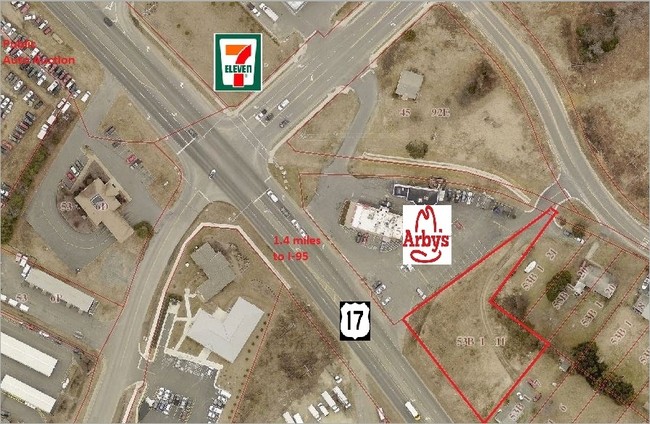
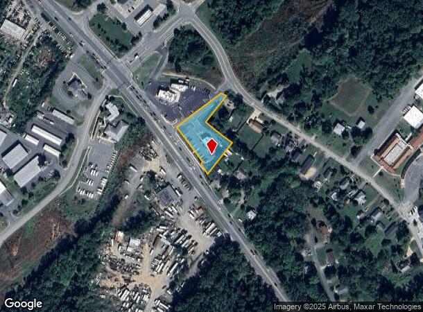
Property Record
150 Warrenton Rd, Fredericksburg, VA 22405
NEARBY LISTINGS FOR SALE OR LEASE
-
-
-
-
-
-
-
-
-
-
-
-
Celebrate Virginia Parkway Pky @ McWhirt Loop
Fredericksburg, VA 22406
$495,000 - $1,963,250
1.05 - 3.43 AC Lot
Land
-
-
View all Fredericksburg listings for sale on LoopNet.com
Property Detail
150 Warrenton Rd
Washington-Arlington-Alexandria, DC-VA-MD-WV
Sunnyside Sub
53B-1-11
LOT 11 REVISED .8089 AC PM190000128
Restaurantdrivein
Stafford
X
Virginia
51179C0203F
11
2024
0.81 AC
2025
Stafford County
010304
Washington, DC
1,399 SF
DEMOGRAPHICS near 150 Warrenton Rd
1 Mile
3 Mile
5 Mile
2024 Total Population
6,179
54,631
99,422
2029 Population
6,954
59,733
109,152
Pop Growth 2024-2029
+ 12.54%
+ 9.34%
+ 9.79%
Average Age
35
38
38
2024 Total Households
2,160
21,230
36,806
HH Growth 2024-2029
+ 12.55%
+ 9.48%
+ 9.85%
Median Household Inc
$73,295
$82,661
$92,366
Avg Household Size
2.90
2.40
2.60
2024 Avg HH Vehicles
2.00
2.00
2.00
Median Home Value
$360,734
$378,444
$370,464
Median Year Built
1998
1993
1993
Nearby Places
Map Layers
Map Styles
 Street
 Aerial
- Restaurants
- Banks
- Shops
- Fitness
- Groceries
PUBLIC TRANSPORTATION
COMMUTER RAIL
Fredericksburg (Fredericksburg Line - Virginia Railway Express)
DRIVE
WALK
Distance
Fredericksburg (Fredericksburg Line - Virginia Railway Express)
7 min
3.3 mi
Leeland Road (Fredericksburg Line - Virginia Railway Express)
DRIVE
WALK
Distance
Leeland Road (Fredericksburg Line - Virginia Railway Express)
9 min
4.5 mi
Freight Ports
Virginia Port Authority - Richmond
DRIVE
WALK
Distance
Virginia Port Authority - Richmond
81 min
66.7 mi
SALE & LEASE HISTORY
LISTING DATE
SALE/LEASE

Sep 24, 2016
For Sale
Nearby Properties
Address
Land Use
TOTAL SIZE
Lot Size
Zoning
Address
Land Use
TOTAL SIZE
Lot Size
Zoning
945,573 SF
22.11 AC
PDMC
Address
Land Use
TOTAL SIZE
Lot Size
Zoning
427,478 SF
15.36 AC
PDC
Address
Land Use
TOTAL SIZE
Lot Size
Zoning
14,500 SF
CT
Address
Land Use
TOTAL SIZE
Lot Size
Zoning
343,471 SF
14.61 AC
CD
Address
Land Use
TOTAL SIZE
Lot Size
Zoning
121,832 SF
0.23 AC
R2
Address
Land Use
TOTAL SIZE
Lot Size
Zoning
282,451 SF
110.89 AC
A1
Address
Land Use
TOTAL SIZE
Lot Size
Zoning
421,851 SF
7.05 AC
PDMU
Address
Land Use
TOTAL SIZE
Lot Size
Zoning
198,000 SF
23.67 AC
R2
Address
Land Use
TOTAL SIZE
Lot Size
Zoning
271,103 SF
16.84 AC
PDC
Address
Land Use
TOTAL SIZE
Lot Size
Zoning
248,662 SF
8.56 AC
PDC
Address
Land Use
TOTAL SIZE
Lot Size
Zoning
234,016 SF
13.48 AC
PDC
Address
Land Use
TOTAL SIZE
Lot Size
Zoning
252,616 SF
22.31 AC
R16
Address
Land Use
TOTAL SIZE
Lot Size
Zoning
80,000 SF
0.51 AC
R2
Address
Land Use
TOTAL SIZE
Lot Size
Zoning
143,003 SF
38.64 AC
R2
Address
Land Use
TOTAL SIZE
Lot Size
Zoning
105,564 SF
1.07 AC
R2
Address
Land Use
TOTAL SIZE
Lot Size
Zoning
188 SF
14.96 AC
R2
Address
Land Use
TOTAL SIZE
Lot Size
Zoning
200 SF
17.92 AC
B2
Address
Land Use
TOTAL SIZE
Lot Size
Zoning
21.89 AC
PDC
Address
Land Use
TOTAL SIZE
Lot Size
Zoning
200,453 SF
14.73 AC
RBC
Address
Land Use
TOTAL SIZE
Lot Size
Zoning
168 SF
11.77 AC
R2
Address
Land Use
TOTAL SIZE
Lot Size
Zoning
100 AC
R2
Address
Land Use
TOTAL SIZE
Lot Size
Zoning
187,097 SF
16.66 AC
R16
Address
Land Use
TOTAL SIZE
Lot Size
Zoning
76,950 SF
0.47 AC
CD
Address
Land Use
TOTAL SIZE
Lot Size
Zoning
610,866 SF
37.59 AC
M1
Address
Land Use
TOTAL SIZE
Lot Size
Zoning
186,909 SF
9.91 AC
RBC
Address
Land Use
TOTAL SIZE
Lot Size
Zoning
56,004 SF
0.46 AC
R2
Address
Land Use
TOTAL SIZE
Lot Size
Zoning
340 SF
20.86 AC
R2
Address
Land Use
TOTAL SIZE
Lot Size
Zoning
164,579 SF
11.81 AC
M1
Address
Land Use
TOTAL SIZE
Lot Size
Zoning
Address
Land Use
TOTAL SIZE
Lot Size
Zoning
162,535 SF
10.67 AC
CH
The World's #1 Commercial Real Estate Marketplace
Connect with us
© 2025 CoStar Group
The information above has been obtained from sources believed reliable. While we do not doubt its accuracy we have not verified it and make no guarantee, warranty or representation about it. It is your responsibility to independently confirm its accuracy and completeness. Any projections, opinions, assumptions, or estimates used are for example only and do not represent the current or future performance of the property. The value of this transaction to you depends on tax and other factors which should be evaluated by your tax, financial, and legal advisors. You and your advisors should conduct a careful, independent investigation of the property to determine to your satisfaction the suitability of the property for your needs.