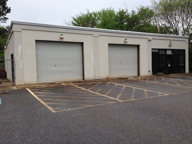
Property Record
150 Whit Davis Rd, Athens, GA 30605
NEARBY LISTINGS FOR SALE OR LEASE
Property Detail
150 Whit Davis Rd
Athens-Clarke County, GA
Com-St-059->00-03
234-024-A
Clarke
Autorepair
Georgia
X
1.30 AC
13059C0037E
Cedar Creek
2,400 SF
Other Market Areas
DEMOGRAPHICS near 150 Whit Davis Rd
1 Mile
3 Mile
5 Mile
2024 Total Population
4,923
31,594
79,307
2029 Population
4,918
31,550
79,609
Pop Growth 2024-2029
(0.10%)
(0.14%)
+ 0.38%
Average Age
38
37
33
2024 Total Households
2,035
13,675
30,694
HH Growth 2024-2029
(0.10%)
(0.07%)
+ 0.36%
Median Household Inc
$56,408
$58,063
$48,229
Avg Household Size
2.30
2.30
2.20
2024 Avg HH Vehicles
2.00
2.00
2.00
Median Home Value
$207,576
$207,324
$240,027
Median Year Built
1983
1988
1986
Nearby Places
Map Layers
Map Styles
 Street
 Aerial
- Restaurants
- Banks
- Shops
- Fitness
- Groceries
Nearby Properties
Address
Land Use
TOTAL SIZE
Lot Size
Zoning
Address
Land Use
TOTAL SIZE
Lot Size
Zoning
300,000 SF
122.56 AC
G
Address
Land Use
TOTAL SIZE
Lot Size
Zoning
104,964 SF
40.38 AC
RM-2
Address
Land Use
TOTAL SIZE
Lot Size
Zoning
225,000 SF
98.91 AC
G
Address
Land Use
TOTAL SIZE
Lot Size
Zoning
56.20 AC
G
Address
Land Use
TOTAL SIZE
Lot Size
Zoning
5.49 AC
G
Address
Land Use
TOTAL SIZE
Lot Size
Zoning
986 SF
40.54 AC
RM-1
Address
Land Use
TOTAL SIZE
Lot Size
Zoning
4,014 SF
19.22 AC
RM-2
Address
Land Use
TOTAL SIZE
Lot Size
Zoning
26.76 AC
G
Address
Land Use
TOTAL SIZE
Lot Size
Zoning
2,062 SF
24.33 AC
RM-1
Address
Land Use
TOTAL SIZE
Lot Size
Zoning
28.91 AC
G
Address
Land Use
TOTAL SIZE
Lot Size
Zoning
3,339 SF
16.80 AC
RM-1
Address
Land Use
TOTAL SIZE
Lot Size
Zoning
1,624 SF
20.04 AC
RM-1
Address
Land Use
TOTAL SIZE
Lot Size
Zoning
74,775 SF
17.95 AC
C-G
Address
Land Use
TOTAL SIZE
Lot Size
Zoning
143,200 SF
19.44 AC
RM-1
Address
Land Use
TOTAL SIZE
Lot Size
Zoning
76.55 AC
RM-1
Address
Land Use
TOTAL SIZE
Lot Size
Zoning
3,339 SF
5.91 AC
C-N
Address
Land Use
TOTAL SIZE
Lot Size
Zoning
47,808 SF
11.08 AC
RM-2
Address
Land Use
TOTAL SIZE
Lot Size
Zoning
16,800 SF
454.45 AC
G
Address
Land Use
TOTAL SIZE
Lot Size
Zoning
12.49 AC
G
Address
Land Use
TOTAL SIZE
Lot Size
Zoning
31.57 AC
G
Address
Land Use
TOTAL SIZE
Lot Size
Zoning
27,918 SF
16.01 AC
RM-1
Address
Land Use
TOTAL SIZE
Lot Size
Zoning
Address
Land Use
TOTAL SIZE
Lot Size
Zoning
11,700 SF
12.05 AC
RM-2
Address
Land Use
TOTAL SIZE
Lot Size
Zoning
26.40 AC
RM-2
Address
Land Use
TOTAL SIZE
Lot Size
Zoning
3,050 SF
8.44 AC
C-G
Address
Land Use
TOTAL SIZE
Lot Size
Zoning
28.89 AC
G
Address
Land Use
TOTAL SIZE
Lot Size
Zoning
77,569 SF
12.18 AC
C-G
Address
Land Use
TOTAL SIZE
Lot Size
Zoning
205,548 SF
22.68 AC
C-G(PD)
Address
Land Use
TOTAL SIZE
Lot Size
Zoning
9,588 SF
12.69 AC
RM-1
Address
Land Use
TOTAL SIZE
Lot Size
Zoning
50,512 SF
10.87 AC
C-G
The World's #1 Commercial Real Estate Marketplace
Connect with us
© 2025 CoStar Group
The information above has been obtained from sources believed reliable. While we do not doubt its accuracy we have not verified it and make no guarantee, warranty or representation about it. It is your responsibility to independently confirm its accuracy and completeness. Any projections, opinions, assumptions, or estimates used are for example only and do not represent the current or future performance of the property. The value of this transaction to you depends on tax and other factors which should be evaluated by your tax, financial, and legal advisors. You and your advisors should conduct a careful, independent investigation of the property to determine to your satisfaction the suitability of the property for your needs.