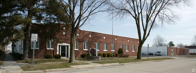
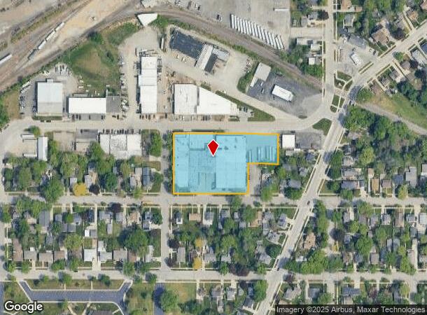
Property Record
1520 W Rogers Ave, Appleton, WI 54914
Current Lease Availabilities
NEARBY LISTINGS FOR SALE OR LEASE
Property Detail
1520 W Rogers Ave
Appleton, WI
Rogers & Co
31-3-0143-00
ROGERS & CO PLAT 3WD LOTS 3,4,5,6,7,8,9,10, 11,12,13, & 14, BLK 6 STATE ASSESSED
Industrialgeneral
Outagamie
X
Wisconsin
55087C0318D
3,4,5
2024
1.98 AC
2024
Outagamie County
010900
Green Bay
DEMOGRAPHICS near 1520 W Rogers Ave
1 Mile
3 Mile
5 Mile
2024 Total Population
9,626
91,073
158,403
2029 Population
9,973
93,671
162,645
Pop Growth 2024-2029
+ 3.60%
+ 2.85%
+ 2.68%
Average Age
39
39
40
2024 Total Households
3,972
38,368
66,102
HH Growth 2024-2029
+ 3.52%
+ 2.80%
+ 2.63%
Median Household Inc
$62,996
$62,370
$69,317
Avg Household Size
2.30
2.20
2.30
2024 Avg HH Vehicles
2.00
2.00
2.00
Median Home Value
$173,560
$174,136
$195,469
Median Year Built
1952
1971
1977
Nearby Places
Map Layers
Map Styles
 Street
 Aerial
- Restaurants
- Banks
- Shops
- Fitness
- Groceries
PUBLIC TRANSPORTATION
AIRPORT
Appleton International
DRIVE
WALK
Distance
Appleton International
12 min
5.7 mi
Green Bay/Austin Straubel International
DRIVE
WALK
Distance
Green Bay/Austin Straubel International
39 min
29.1 mi
Freight Ports
Port Milwaukee
DRIVE
WALK
Distance
Port Milwaukee
126 min
107.5 mi
Nearby Properties
Address
Land Use
TOTAL SIZE
Lot Size
Zoning
Address
Land Use
TOTAL SIZE
Lot Size
Zoning
645,392 SF
25.87 AC
Address
Land Use
TOTAL SIZE
Lot Size
Zoning
8.61 AC
R5
Address
Land Use
TOTAL SIZE
Lot Size
Zoning
3.42 AC
PDC2
Address
Land Use
TOTAL SIZE
Lot Size
Zoning
20.37 AC
PDC2
Address
Land Use
TOTAL SIZE
Lot Size
Zoning
29,742 SF
5.95 AC
R3
Address
Land Use
TOTAL SIZE
Lot Size
Zoning
267,069 SF
26.76 AC
Address
Land Use
TOTAL SIZE
Lot Size
Zoning
278,801 SF
20.94 AC
Address
Land Use
TOTAL SIZE
Lot Size
Zoning
53,321 SF
2.51 AC
CBD
Address
Land Use
TOTAL SIZE
Lot Size
Zoning
209,059 SF
18.40 AC
PDC2
Address
Land Use
TOTAL SIZE
Lot Size
Zoning
44,164 SF
0.62 AC
CBD
Address
Land Use
TOTAL SIZE
Lot Size
Zoning
17.43 AC
M2
Address
Land Use
TOTAL SIZE
Lot Size
Zoning
81,252 SF
8.32 AC
Address
Land Use
TOTAL SIZE
Lot Size
Zoning
20.92 AC
R5
Address
Land Use
TOTAL SIZE
Lot Size
Zoning
249,444 SF
18.81 AC
Address
Land Use
TOTAL SIZE
Lot Size
Zoning
20,874 SF
11.57 AC
R4
Address
Land Use
TOTAL SIZE
Lot Size
Zoning
67,817 SF
21.36 AC
C2
Address
Land Use
TOTAL SIZE
Lot Size
Zoning
82,199 SF
6.97 AC
Address
Land Use
TOTAL SIZE
Lot Size
Zoning
5,394 SF
0.30 AC
CBD
Address
Land Use
TOTAL SIZE
Lot Size
Zoning
62,673 SF
3.19 AC
PDC2
Address
Land Use
TOTAL SIZE
Lot Size
Zoning
21,540 SF
0.79 AC
CBD
Address
Land Use
TOTAL SIZE
Lot Size
Zoning
194,738 SF
19.73 AC
Address
Land Use
TOTAL SIZE
Lot Size
Zoning
25,705 SF
2.03 AC
PDR3
Address
Land Use
TOTAL SIZE
Lot Size
Zoning
92,296 SF
13.33 AC
R1
Address
Land Use
TOTAL SIZE
Lot Size
Zoning
78,268 SF
7.80 AC
C3
Address
Land Use
TOTAL SIZE
Lot Size
Zoning
83,926 SF
7.35 AC
C2
Address
Land Use
TOTAL SIZE
Lot Size
Zoning
1.91 AC
B5
Address
Land Use
TOTAL SIZE
Lot Size
Zoning
45,646 SF
44 SF
PDC2
Address
Land Use
TOTAL SIZE
Lot Size
Zoning
18.18 AC
I1
Address
Land Use
TOTAL SIZE
Lot Size
Zoning
83,673 SF
1.48 AC
PDC2
Address
Land Use
TOTAL SIZE
Lot Size
Zoning
15,650 SF
1.45 AC
PDC2
The World's #1 Commercial Real Estate Marketplace
Connect with us
© 2026 CoStar Group
The information above has been obtained from sources believed reliable. While we do not doubt its accuracy we have not verified it and make no guarantee, warranty or representation about it. It is your responsibility to independently confirm its accuracy and completeness. Any projections, opinions, assumptions, or estimates used are for example only and do not represent the current or future performance of the property. The value of this transaction to you depends on tax and other factors which should be evaluated by your tax, financial, and legal advisors. You and your advisors should conduct a careful, independent investigation of the property to determine to your satisfaction the suitability of the property for your needs.