Property Record
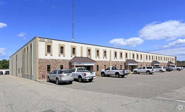
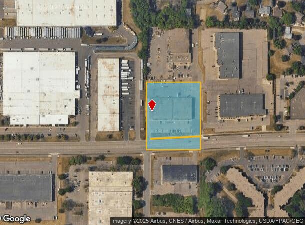
1500 Cliff Rd E, Burnsville, MN 55337
Current Lease Availabilities
NEARBY LISTINGS FOR SALE OR LEASE
Property Detail
1500 Cliff Rd E
02-02610-89-010
26 2724 W 300 FT OF S 376.24 FT OF E 9.5 AC OF SW 1/4 OF SE 1/4 LYING N OF CLIFF RD SUB TO ESMT OVER E 35.8 FT EX PARCEL 10J MN-DOT R/W PLAT NO 19-107 SECTION 26 TWN 27 RANGE 24
Industrialgeneral
Dakota
X
Minnesota
27053C0467F
10
2024
2.56 AC
2024
South Central
060748
Minneapolis/St Paul
34,456 SF
Minneapolis-St. Paul-Bloomington, MN-WI
DEMOGRAPHICS near 1500 Cliff Rd E
1 Mile
3 Mile
5 Mile
2024 Total Population
8,816
69,501
197,898
2029 Population
8,950
70,215
199,958
Pop Growth 2024-2029
+ 1.52%
+ 1.03%
+ 1.04%
Average Age
38
40
41
2024 Total Households
3,742
28,483
79,108
HH Growth 2024-2029
+ 1.60%
+ 1.07%
+ 1.08%
Median Household Inc
$77,110
$80,830
$85,090
Avg Household Size
2.30
2.30
2.40
2024 Avg HH Vehicles
2.00
2.00
2.00
Median Home Value
$269,580
$299,292
$310,802
Median Year Built
1979
1978
1979
Nearby Places
- Restaurants
- Banks
- Shops
- Fitness
- Groceries
PUBLIC TRANSPORTATION
AIRPORT
Minneapolis-St Paul International/Wold-Chamberlain
DRIVE
WALK
Distance
Minneapolis-St Paul International/Wold-Chamberlain
16 min
8.8 mi
Freight Ports
Port Milwaukee
DRIVE
WALK
Distance
Port Milwaukee
381 min
343.3 mi
Nearby Properties
Address
Land Use
TOTAL SIZE
Lot Size
Zoning
Address
Land Use
TOTAL SIZE
Lot Size
Zoning
1,341.19 AC
Address
Land Use
TOTAL SIZE
Lot Size
Zoning
752,064 SF
24.03 AC
Address
Land Use
TOTAL SIZE
Lot Size
Zoning
129,658 SF
13.52 AC
Address
Land Use
TOTAL SIZE
Lot Size
Zoning
300,663 SF
4.81 AC
Address
Land Use
TOTAL SIZE
Lot Size
Zoning
122,021 SF
21.74 AC
Address
Land Use
TOTAL SIZE
Lot Size
Zoning
168,729 SF
19.02 AC
Address
Land Use
TOTAL SIZE
Lot Size
Zoning
584,692 SF
15.70 AC
Address
Land Use
TOTAL SIZE
Lot Size
Zoning
282,095 SF
2.71 AC
Address
Land Use
TOTAL SIZE
Lot Size
Zoning
230,883 SF
2.49 AC
Address
Land Use
TOTAL SIZE
Lot Size
Zoning
263,460 SF
3.08 AC
Address
Land Use
TOTAL SIZE
Lot Size
Zoning
142,229 SF
26.61 AC
Address
Land Use
TOTAL SIZE
Lot Size
Zoning
24,750 SF
14.36 AC
Address
Land Use
TOTAL SIZE
Lot Size
Zoning
419,750 SF
13.83 AC
Address
Land Use
TOTAL SIZE
Lot Size
Zoning
299,435 SF
7.65 AC
Address
Land Use
TOTAL SIZE
Lot Size
Zoning
374,415 SF
20.10 AC
Address
Land Use
TOTAL SIZE
Lot Size
Zoning
273,843 SF
17.55 AC
Address
Land Use
TOTAL SIZE
Lot Size
Zoning
177,489 SF
1.75 AC
Address
Land Use
TOTAL SIZE
Lot Size
Zoning
216,267 SF
3.69 AC
Address
Land Use
TOTAL SIZE
Lot Size
Zoning
234,348 SF
11.21 AC
Address
Land Use
TOTAL SIZE
Lot Size
Zoning
174,245 SF
2.90 AC
Address
Land Use
TOTAL SIZE
Lot Size
Zoning
287,255 SF
14.69 AC
Address
Land Use
TOTAL SIZE
Lot Size
Zoning
256,907 SF
7.43 AC
Address
Land Use
TOTAL SIZE
Lot Size
Zoning
260,290 SF
13.28 AC
Address
Land Use
TOTAL SIZE
Lot Size
Zoning
112.48 AC
Address
Land Use
TOTAL SIZE
Lot Size
Zoning
158,620 SF
1.80 AC
Address
Land Use
TOTAL SIZE
Lot Size
Zoning
134,140 SF
6.39 AC
Address
Land Use
TOTAL SIZE
Lot Size
Zoning
62,165 SF
13.21 AC
Address
Land Use
TOTAL SIZE
Lot Size
Zoning
231,928 SF
16.63 AC
Address
Land Use
TOTAL SIZE
Lot Size
Zoning
178,425 SF
9.18 AC
The World's #1 Commercial Real Estate Marketplace
Connect with us
© 2025 CoStar Group
The information above has been obtained from sources believed reliable. While we do not doubt its accuracy we have not verified it and make no guarantee, warranty or representation about it. It is your responsibility to independently confirm its accuracy and completeness. Any projections, opinions, assumptions, or estimates used are for example only and do not represent the current or future performance of the property. The value of this transaction to you depends on tax and other factors which should be evaluated by your tax, financial, and legal advisors. You and your advisors should conduct a careful, independent investigation of the property to determine to your satisfaction the suitability of the property for your needs.