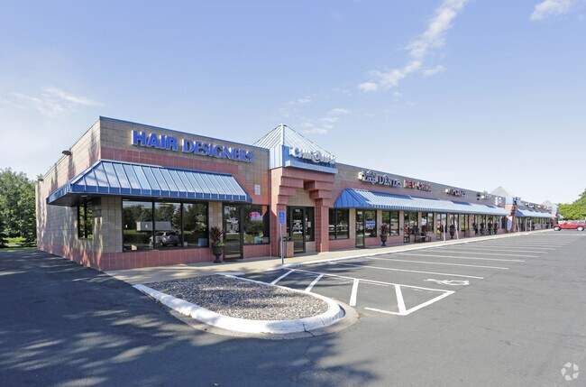
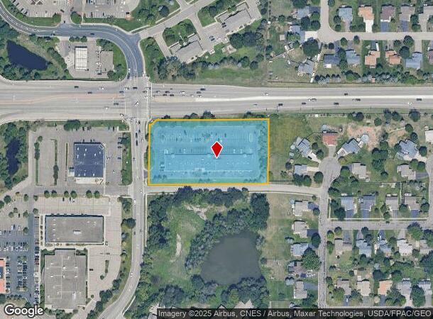
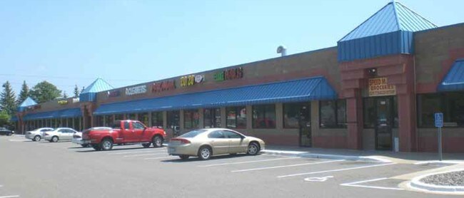
Property Record
1542 125Th Ave Ne, Blaine, MN 55449
NEARBY LISTINGS FOR SALE OR LEASE
Property Detail
1542 125Th Ave Ne
Minneapolis-St. Paul-Bloomington, MN-WI
Northgate Mall Add
08-31-23-12-0015
LOT 6; EX W 4 FT THEREOF; LOT 7 & N 41 FT OF THAT PRT OF LOT 8 LYG E OF W 4 FT THEREOF ALL IN BLK 1 NORTH- GATE MALL ADD; SUB
Commercialnec
Anoka
X
Minnesota
27003C0328E
6
2024
2.69 AC
2025
Coon Rapids
050820
Minneapolis/St Paul
19,965 SF
DEMOGRAPHICS near 1542 125Th Ave Ne
1 Mile
3 Mile
5 Mile
2024 Total Population
10,925
62,915
142,789
2029 Population
11,301
65,608
148,724
Pop Growth 2024-2029
+ 3.44%
+ 4.28%
+ 4.16%
Average Age
38
39
39
2024 Total Households
3,915
22,228
51,148
HH Growth 2024-2029
+ 3.35%
+ 4.22%
+ 4.13%
Median Household Inc
$95,528
$101,324
$92,873
Avg Household Size
2.70
2.80
2.70
2024 Avg HH Vehicles
2.00
2.00
2.00
Median Home Value
$280,331
$315,203
$292,641
Median Year Built
1991
1994
1990
Nearby Places
Map Layers
Map Styles
 Street
 Aerial
- Restaurants
- Banks
- Shops
- Fitness
- Groceries
PUBLIC TRANSPORTATION
COMMUTER RAIL
Coon Rapids-Riverdale Station (Northstar Corridor - Northstar Commuter Rail)
DRIVE
WALK
Distance
Coon Rapids-Riverdale Station (Northstar Corridor - Northstar Commuter Rail)
12 min
6.3 mi
Anoka Station (Northstar Corridor - Northstar Commuter Rail)
DRIVE
WALK
Distance
Anoka Station (Northstar Corridor - Northstar Commuter Rail)
14 min
8.0 mi
AIRPORT
Minneapolis-St Paul International/Wold-Chamberlain
DRIVE
WALK
Distance
Minneapolis-St Paul International/Wold-Chamberlain
42 min
28.1 mi
Freight Ports
Port Milwaukee
DRIVE
WALK
Distance
Port Milwaukee
388 min
350.3 mi
SALE & LEASE HISTORY
LISTING DATE
SALE/LEASE

Jul 13, 2017
For Lease
Nearby Properties
Address
Land Use
TOTAL SIZE
Lot Size
Zoning
Address
Land Use
TOTAL SIZE
Lot Size
Zoning
100,260 SF
74.82 AC
Address
Land Use
TOTAL SIZE
Lot Size
Zoning
1,075 SF
41.99 AC
Address
Land Use
TOTAL SIZE
Lot Size
Zoning
8,400 SF
10.10 AC
Address
Land Use
TOTAL SIZE
Lot Size
Zoning
225,576 SF
6.07 AC
Address
Land Use
TOTAL SIZE
Lot Size
Zoning
179,853 SF
37.73 AC
Address
Land Use
TOTAL SIZE
Lot Size
Zoning
192 SF
11.30 AC
Address
Land Use
TOTAL SIZE
Lot Size
Zoning
105,324 SF
13.36 AC
Address
Land Use
TOTAL SIZE
Lot Size
Zoning
76,383 SF
7.60 AC
Address
Land Use
TOTAL SIZE
Lot Size
Zoning
98,642 SF
20.01 AC
Address
Land Use
TOTAL SIZE
Lot Size
Zoning
104,477 SF
18 AC
Address
Land Use
TOTAL SIZE
Lot Size
Zoning
119,907 SF
36.99 AC
Address
Land Use
TOTAL SIZE
Lot Size
Zoning
135,994 SF
3.20 AC
Address
Land Use
TOTAL SIZE
Lot Size
Zoning
162,450 SF
9.97 AC
Address
Land Use
TOTAL SIZE
Lot Size
Zoning
83,688 SF
5.75 AC
Address
Land Use
TOTAL SIZE
Lot Size
Zoning
179,523 SF
16.58 AC
Address
Land Use
TOTAL SIZE
Lot Size
Zoning
8,410 SF
12.69 AC
Address
Land Use
TOTAL SIZE
Lot Size
Zoning
23,014 SF
12.95 AC
Address
Land Use
TOTAL SIZE
Lot Size
Zoning
168,694 SF
10.70 AC
Address
Land Use
TOTAL SIZE
Lot Size
Zoning
145,312 SF
1.84 AC
Address
Land Use
TOTAL SIZE
Lot Size
Zoning
76,374 SF
4.91 AC
Address
Land Use
TOTAL SIZE
Lot Size
Zoning
222,027 SF
14.94 AC
Address
Land Use
TOTAL SIZE
Lot Size
Zoning
156,889 SF
18.95 AC
Address
Land Use
TOTAL SIZE
Lot Size
Zoning
45,735 SF
4.02 AC
Address
Land Use
TOTAL SIZE
Lot Size
Zoning
51,658 SF
3.42 AC
Address
Land Use
TOTAL SIZE
Lot Size
Zoning
46,668 SF
9.18 AC
Address
Land Use
TOTAL SIZE
Lot Size
Zoning
10,912 SF
1.97 AC
Address
Land Use
TOTAL SIZE
Lot Size
Zoning
34,444 SF
5.69 AC
Address
Land Use
TOTAL SIZE
Lot Size
Zoning
8,680 SF
8.12 AC
Address
Land Use
TOTAL SIZE
Lot Size
Zoning
67,108 SF
9.35 AC
The World's #1 Commercial Real Estate Marketplace
Connect with us
© 2025 CoStar Group
The information above has been obtained from sources believed reliable. While we do not doubt its accuracy we have not verified it and make no guarantee, warranty or representation about it. It is your responsibility to independently confirm its accuracy and completeness. Any projections, opinions, assumptions, or estimates used are for example only and do not represent the current or future performance of the property. The value of this transaction to you depends on tax and other factors which should be evaluated by your tax, financial, and legal advisors. You and your advisors should conduct a careful, independent investigation of the property to determine to your satisfaction the suitability of the property for your needs.