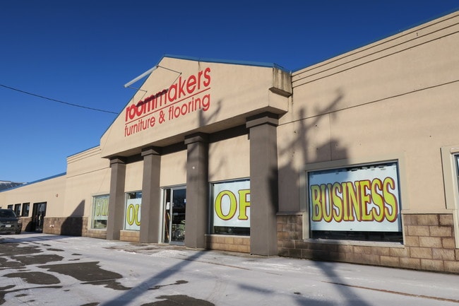
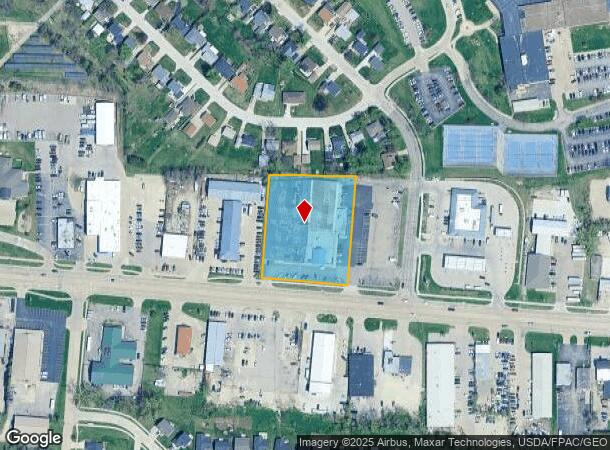
Property Record
1500 20Th St Sw, Cedar Rapids, IA 52404
NEARBY LISTINGS FOR SALE OR LEASE
Property Detail
1500 20Th St Sw
Storebuilding
LANDS N OF RD E 250 W 310 ON S LN BNG E 250.5 W 339.18 ON N LN 313.08 ON E LN & 286 ON W LN NE NE STR/LB 31 83 7
X
Linn
19113C0405F
Iowa
2024
1.72 AC
2025
Other Market Areas
002400
Cedar Rapids, IA
48,856 SF
14311-02002-00000
DEMOGRAPHICS near 1500 20Th St Sw
1 Mile
3 Mile
5 Mile
2024 Total Population
9,501
62,827
120,794
2029 Population
9,427
62,951
120,550
Pop Growth 2024-2029
(0.78%)
+ 0.20%
(0.20%)
Average Age
40
40
40
2024 Total Households
4,018
26,959
51,122
HH Growth 2024-2029
(0.80%)
+ 0.24%
(0.20%)
Median Household Inc
$54,100
$55,888
$62,049
Avg Household Size
2.30
2.20
2.20
2024 Avg HH Vehicles
2.00
2.00
2.00
Median Home Value
$146,334
$156,007
$167,758
Median Year Built
1961
1972
1970
Nearby Places
Map Layers
Map Styles
 Street
 Aerial
- Restaurants
- Banks
- Shops
- Fitness
- Groceries
PUBLIC TRANSPORTATION
AIRPORT
The Eastern Iowa
DRIVE
WALK
Distance
The Eastern Iowa
12 min
6.3 mi
Freight Ports
Port Milwaukee
DRIVE
WALK
Distance
Port Milwaukee
298 min
249.2 mi
SALE & LEASE HISTORY
LISTING DATE
SALE/LEASE

Oct 26, 2018
For Sale
Oct 26, 2018
For Lease
Nearby Properties
Address
Land Use
TOTAL SIZE
Lot Size
Zoning
Address
Land Use
TOTAL SIZE
Lot Size
Zoning
429,314 SF
14.92 AC
Address
Land Use
TOTAL SIZE
Lot Size
Zoning
355,567 SF
14.60 AC
Address
Land Use
TOTAL SIZE
Lot Size
Zoning
1,012,084 SF
45.85 AC
Address
Land Use
TOTAL SIZE
Lot Size
Zoning
171,842 SF
4.16 AC
Address
Land Use
TOTAL SIZE
Lot Size
Zoning
264,086 SF
21.44 AC
Address
Land Use
TOTAL SIZE
Lot Size
Zoning
308,309 SF
17.97 AC
Address
Land Use
TOTAL SIZE
Lot Size
Zoning
550,428 SF
78.91 AC
Address
Land Use
TOTAL SIZE
Lot Size
Zoning
65,970 SF
2.07 AC
Address
Land Use
TOTAL SIZE
Lot Size
Zoning
73,012 SF
2.60 AC
Address
Land Use
TOTAL SIZE
Lot Size
Zoning
427,700 SF
12.67 AC
Address
Land Use
TOTAL SIZE
Lot Size
Zoning
218,451 SF
18.74 AC
Address
Land Use
TOTAL SIZE
Lot Size
Zoning
68,553 SF
7.70 AC
Address
Land Use
TOTAL SIZE
Lot Size
Zoning
125,013 SF
0.97 AC
Address
Land Use
TOTAL SIZE
Lot Size
Zoning
60,910 SF
2.48 AC
Address
Land Use
TOTAL SIZE
Lot Size
Zoning
97,612 SF
0.89 AC
Address
Land Use
TOTAL SIZE
Lot Size
Zoning
42,449 SF
4.70 AC
Address
Land Use
TOTAL SIZE
Lot Size
Zoning
1,049,268 SF
79.35 AC
Address
Land Use
TOTAL SIZE
Lot Size
Zoning
67,971 SF
Address
Land Use
TOTAL SIZE
Lot Size
Zoning
59,467 SF
8.39 AC
Address
Land Use
TOTAL SIZE
Lot Size
Zoning
36,803 SF
2.53 AC
Address
Land Use
TOTAL SIZE
Lot Size
Zoning
23,585 SF
1.05 AC
Address
Land Use
TOTAL SIZE
Lot Size
Zoning
110,583 SF
15.56 AC
Address
Land Use
TOTAL SIZE
Lot Size
Zoning
80,530 SF
2.96 AC
Address
Land Use
TOTAL SIZE
Lot Size
Zoning
66,922 SF
4.90 AC
Address
Land Use
TOTAL SIZE
Lot Size
Zoning
156,678 SF
21.85 AC
Address
Land Use
TOTAL SIZE
Lot Size
Zoning
32,855 SF
1.37 AC
Address
Land Use
TOTAL SIZE
Lot Size
Zoning
907,717 SF
152.19 AC
Address
Land Use
TOTAL SIZE
Lot Size
Zoning
56,178 SF
0.97 AC
Address
Land Use
TOTAL SIZE
Lot Size
Zoning
315,459 SF
13.85 AC
Address
Land Use
TOTAL SIZE
Lot Size
Zoning
416,830 SF
18.06 AC
The World's #1 Commercial Real Estate Marketplace
Connect with us
© 2026 CoStar Group
The information above has been obtained from sources believed reliable. While we do not doubt its accuracy we have not verified it and make no guarantee, warranty or representation about it. It is your responsibility to independently confirm its accuracy and completeness. Any projections, opinions, assumptions, or estimates used are for example only and do not represent the current or future performance of the property. The value of this transaction to you depends on tax and other factors which should be evaluated by your tax, financial, and legal advisors. You and your advisors should conduct a careful, independent investigation of the property to determine to your satisfaction the suitability of the property for your needs.