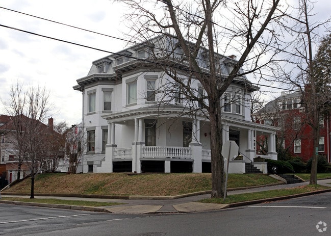
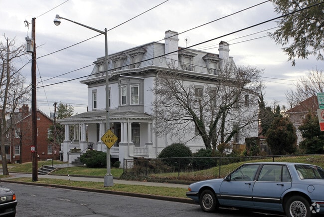
Property Record
1500 Delafield Pl Nw, Washington, DC 20011

NEARBY LISTINGS FOR SALE OR LEASE
Property Detail
1500 Delafield Pl Nw
Washington-Arlington-Alexandria, DC-VA-MD-WV
16Th Street Heights
2708-0040
SQUARE 2708 LOT 0040 NBHD: 16TH STREET HEIGHTS
Nightclub
District of Columbia
X
District of Columbia
24033C0110E
40
2025
0.14 AC
2025
Uptown
002002
Washington, DC
10,302 SF
DEMOGRAPHICS near 1500 Delafield Pl Nw
1 Mile
3 Mile
5 Mile
2024 Total Population
36,525
327,485
753,046
2029 Population
32,820
298,213
707,712
Pop Growth 2024-2029
(10.14%)
(8.94%)
(6.02%)
Average Age
38
39
38
2024 Total Households
14,104
152,377
336,972
HH Growth 2024-2029
(10.97%)
(9.84%)
(6.79%)
Median Household Inc
$96,973
$109,269
$105,729
Avg Household Size
2.40
2.00
2.10
2024 Avg HH Vehicles
1.00
1.00
1.00
Median Home Value
$760,938
$772,620
$759,332
Median Year Built
1948
1950
1959
Nearby Places
Map Layers
Map Styles
 Street
 Aerial
- Restaurants
- Banks
- Shops
- Fitness
- Groceries
PUBLIC TRANSPORTATION
COMMUTER RAIL
Silver Spring (Brunswick Line - Maryland Area Regional Commuter Trains (The MARC))
DRIVE
WALK
Distance
Silver Spring (Brunswick Line - Maryland Area Regional Commuter Trains (The MARC))
10 min
3.5 mi
DRIVE
WALK
Distance
11 min
5.3 mi
AIRPORT
Ronald Reagan Washington Ntl
DRIVE
WALK
Distance
Ronald Reagan Washington Ntl
19 min
8.5 mi
Washington Dulles International
DRIVE
WALK
Distance
Washington Dulles International
51 min
29.5 mi
Baltimore/Washington International Thurgood Marshall
DRIVE
WALK
Distance
Baltimore/Washington International Thurgood Marshall
49 min
32.8 mi
Freight Ports
Port of Baltimore
DRIVE
WALK
Distance
Port of Baltimore
53 min
35.5 mi
Nearby Properties
Address
Land Use
TOTAL SIZE
Lot Size
Zoning
Address
Land Use
TOTAL SIZE
Lot Size
Zoning
1,583,364 SF
276.66 AC
UNZONED
Address
Land Use
TOTAL SIZE
Lot Size
Zoning
70,860 SF
1,616.16 AC
R-1A;UNZON
Address
Land Use
TOTAL SIZE
Lot Size
Zoning
553,914 SF
55.91 AC
R-1B
Address
Land Use
TOTAL SIZE
Lot Size
Zoning
1,562,988 SF
15.33 AC
MU-10 (IZ+
Address
Land Use
TOTAL SIZE
Lot Size
Zoning
900,000 SF
12.60 AC
RA-4
Address
Land Use
TOTAL SIZE
Lot Size
Zoning
95.32 AC
RA-1
Address
Land Use
TOTAL SIZE
Lot Size
Zoning
247,900 SF
170.58 AC
RA-2;UNZON
Address
Land Use
TOTAL SIZE
Lot Size
Zoning
1,835,827 SF
34.66 AC
UNZONED
Address
Land Use
TOTAL SIZE
Lot Size
Zoning
Address
Land Use
TOTAL SIZE
Lot Size
Zoning
791,730 SF
37.44 AC
RA-1
Address
Land Use
TOTAL SIZE
Lot Size
Zoning
795,214 SF
MU-5A
Address
Land Use
TOTAL SIZE
Lot Size
Zoning
1,095,275 SF
30.70 AC
MU-4;RA-2
Address
Land Use
TOTAL SIZE
Lot Size
Zoning
823,802 SF
7.30 AC
MU-2
Address
Land Use
TOTAL SIZE
Lot Size
Zoning
997,890 SF
6.30 AC
CR3.0
Address
Land Use
TOTAL SIZE
Lot Size
Zoning
1,452,667 SF
43.94 AC
R-1B;RA-1
Address
Land Use
TOTAL SIZE
Lot Size
Zoning
10,158 SF
97.34 AC
MU-10;MU-1
Address
Land Use
TOTAL SIZE
Lot Size
Zoning
256,187 SF
8.97 AC
RA-2
Address
Land Use
TOTAL SIZE
Lot Size
Zoning
902,764 SF
2.87 AC
MU-5A
Address
Land Use
TOTAL SIZE
Lot Size
Zoning
399,180 SF
0.46 AC
D-5
Address
Land Use
TOTAL SIZE
Lot Size
Zoning
468,389 SF
0.76 AC
MU-9B/DC
Address
Land Use
TOTAL SIZE
Lot Size
Zoning
394,104 SF
0.86 AC
D-5
Address
Land Use
TOTAL SIZE
Lot Size
Zoning
1,237,319 SF
4.37 AC
RA-4
Address
Land Use
TOTAL SIZE
Lot Size
Zoning
444,526 SF
0.75 AC
D-5
Address
Land Use
TOTAL SIZE
Lot Size
Zoning
244,615 SF
19.61 AC
R-1A/FH
Address
Land Use
TOTAL SIZE
Lot Size
Zoning
69.17 AC
R-1B
Address
Land Use
TOTAL SIZE
Lot Size
Zoning
505,408 SF
12.46 AC
RA-1
Address
Land Use
TOTAL SIZE
Lot Size
Zoning
520,000 SF
2.65 AC
MU-10;RA-5
Address
Land Use
TOTAL SIZE
Lot Size
Zoning
516,328 SF
13.19 AC
R-1B
Address
Land Use
TOTAL SIZE
Lot Size
Zoning
316,393 SF
13.61 AC
R-1A
Address
Land Use
TOTAL SIZE
Lot Size
Zoning
281,191 SF
0.54 AC
D-2
The World's #1 Commercial Real Estate Marketplace
Connect with us
© 2026 CoStar Group
The information above has been obtained from sources believed reliable. While we do not doubt its accuracy we have not verified it and make no guarantee, warranty or representation about it. It is your responsibility to independently confirm its accuracy and completeness. Any projections, opinions, assumptions, or estimates used are for example only and do not represent the current or future performance of the property. The value of this transaction to you depends on tax and other factors which should be evaluated by your tax, financial, and legal advisors. You and your advisors should conduct a careful, independent investigation of the property to determine to your satisfaction the suitability of the property for your needs.