Property Record
1500 E Florence Ave, Los Angeles, CA 90001
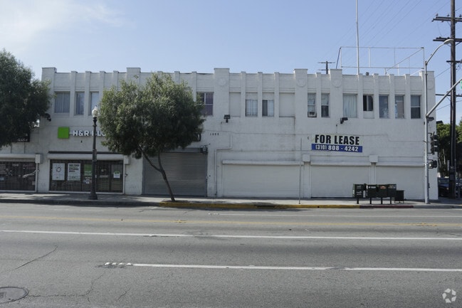


Current Lease Availabilities
General Retail LEASE
$36.00 - $42.00 SF/YR
355 - 3,000 SF
Property Detail
1500 E Florence Ave
6021-015-002
LOT COM AT INTERSECTION OF S LINE OF FLORENCE AVE PER CF1184 WITH E LINE OF COMPTON AVE PER CF2239 TH S 89 50 E 91.85 FT TH S 0 0330 E 120 FT TH N 89 50 W TO A PT S 89 50 E 99.92 FT FROM W 1/2 OF NE 1/4 OF SEC 28 T 2S R 13W
Retailwithmorethanonenonretailuse
Los Angeles
LCC2*
California
B and X Area of moderate flood hazard, usually the area between the limits of the 100-year and 500-year floods.
28
2025
0.17 AC
2025
Mid-Cities
535002
Los Angeles
17,601 SF
Los Angeles-Long Beach-Glendale, CA
NEARBY LISTINGS FOR SALE OR LEASE
DEMOGRAPHICS near 1500 E Florence Ave
1 mile
3 mile
5 mile
2025 Total Population
49,305
450,002
1,057,534
2030 Population
48,185
440,102
1,038,782
Pop Growth 2025-2030
(2.27%)
(2.20%)
(1.77%)
Average Age
35
35
36
2025 Total Households
11,708
111,200
290,259
HH Growth 2025-2030
(2.60%)
(2.54%)
(1.88%)
Median Household Inc
$61,304
$58,809
$60,079
Avg Household Size
4.00
3.80
3.40
2025 Avg HH Vehicles
2.00
2.00
2.00
Median Home Value
$595,684
$651,585
$691,770
Median Year Built
1949
1951
1953
Nearby Places
Map Layers
Map Styles
 Street
 Aerial
Layers
 Traffic
 Biking
Places
Listings with unknown addresses are not visible on the map
- Restaurants
- Banks
- Shops
- Fitness
- Groceries
PUBLIC TRANSPORTATION
TRANSIT/SUBWAY
Florence Station (Blue Line - Los Angeles County Metropolitan Transportation Authority (Metro))
Drive
Walk
Distance
Florence Station (Blue Line - Los Angeles County Metropolitan Transportation Authority (Metro))
1 min
7 min
0.4 mi
COMMUTER RAIL
Commerce (91 Line - Southern California Regional Rail Authority (Metrolink), Orange County Line - Southern California Regional Rail Authority (Metrolink))
Drive
Walk
Distance
Commerce (91 Line - Southern California Regional Rail Authority (Metrolink), Orange County Line - Southern California Regional Rail Authority (Metrolink))
22 min
8.0 mi
Montebello/Commerce (Riverside Line - Southern California Regional Rail Authority (Metrolink))
Drive
Walk
Distance
Montebello/Commerce (Riverside Line - Southern California Regional Rail Authority (Metrolink))
25 min
9.5 mi
AIRPORT
Los Angeles International
Drive
Walk
Distance
Los Angeles International
21 min
13.8 mi
Long Beach (Daugherty Field)
Drive
Walk
Distance
Long Beach (Daugherty Field)
25 min
19.7 mi
Bob Hope
Drive
Walk
Distance
Bob Hope
33 min
24.3 mi
Freight Ports
Port of Long Beach
Drive
Walk
Distance
Port of Long Beach
1 min
14.7 mi
Nearby Properties
Address
Land Use
TOTAL SIZE
Lot Size
Zoning
Address
Land Use
TOTAL SIZE
Lot Size
Zoning
227,179 SF
10.46 AC
VEM*
Address
Land Use
TOTAL SIZE
Lot Size
Zoning
326,472 SF
14.53 AC
VEM*
Address
Land Use
TOTAL SIZE
Lot Size
Zoning
188,319 SF
11.25 AC
VEM&MS1*
Address
Land Use
TOTAL SIZE
Lot Size
Zoning
108,598 SF
15.93 AC
LCC3*
Address
Land Use
TOTAL SIZE
Lot Size
Zoning
184,770 SF
VEM*
Address
Land Use
TOTAL SIZE
Lot Size
Zoning
251,338 SF
10.62 AC
LAM3
Address
Land Use
TOTAL SIZE
Lot Size
Zoning
330,904 SF
12.09 AC
VEM*
Address
Land Use
TOTAL SIZE
Lot Size
Zoning
116,728 SF
0.86 AC
HPCP*
Address
Land Use
TOTAL SIZE
Lot Size
Zoning
372,634 SF
10.83 AC
VEM*
Address
Land Use
TOTAL SIZE
Lot Size
Zoning
369,554 SF
8.49 AC
VEM*
Address
Land Use
TOTAL SIZE
Lot Size
Zoning
261,540 SF
10.85 AC
VEM*
Address
Land Use
TOTAL SIZE
Lot Size
Zoning
100,515 SF
7.45 AC
VEM&MS1*
Address
Land Use
TOTAL SIZE
Lot Size
Zoning
386,865 SF
6 AC
VEM*
Address
Land Use
TOTAL SIZE
Lot Size
Zoning
108,641 SF
5.34 AC
VEM*
Address
Land Use
TOTAL SIZE
Lot Size
Zoning
353,151 SF
8.28 AC
VEM*
Address
Land Use
TOTAL SIZE
Lot Size
Zoning
289,913 SF
8.25 AC
VEM*
Address
Land Use
TOTAL SIZE
Lot Size
Zoning
99,065 SF
4.51 AC
VEM*
Address
Land Use
TOTAL SIZE
Lot Size
Zoning
183,319 SF
9.77 AC
VEM*
Address
Land Use
TOTAL SIZE
Lot Size
Zoning
2.65 AC
HPM2
Address
Land Use
TOTAL SIZE
Lot Size
Zoning
132,544 SF
3.24 AC
LAM2
Address
Land Use
TOTAL SIZE
Lot Size
Zoning
115,340 SF
3.21 AC
LAM2
Address
Land Use
TOTAL SIZE
Lot Size
Zoning
127,484 SF
7.33 AC
LAM2
Address
Land Use
TOTAL SIZE
Lot Size
Zoning
165,235 SF
1.13 AC
LAM2
Address
Land Use
TOTAL SIZE
Lot Size
Zoning
811,955 SF
18.57 AC
VEM*
Address
Land Use
TOTAL SIZE
Lot Size
Zoning
81,735 SF
4.10 AC
LAR4
Address
Land Use
TOTAL SIZE
Lot Size
Zoning
197,131 SF
9.16 AC
VEM*
Address
Land Use
TOTAL SIZE
Lot Size
Zoning
320,526 SF
7.92 AC
VEM*
Address
Land Use
TOTAL SIZE
Lot Size
Zoning
104,291 SF
7.35 AC
LAR3
Address
Land Use
TOTAL SIZE
Lot Size
Zoning
262,928 SF
VEM*
Address
Land Use
TOTAL SIZE
Lot Size
Zoning
134,514 SF
1.94 AC
LCM2*
The World's #1 Commercial Real Estate Marketplace
Connect with us
© 2026 CoStar Group
The information above has been obtained from sources believed reliable. While we do not doubt its accuracy we have not verified it and make no guarantee, warranty or representation about it. It is your responsibility to independently confirm its accuracy and completeness. Any projections, opinions, assumptions, or estimates used are for example only and do not represent the current or future performance of the property. The value of this transaction to you depends on tax and other factors which should be evaluated by your tax, financial, and legal advisors. You and your advisors should conduct a careful, independent investigation of the property to determine to your satisfaction the suitability of the property for your needs.