Property Record
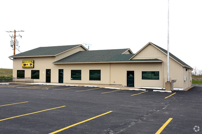
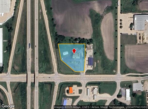
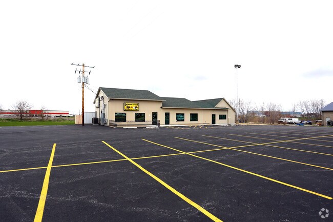
1500 E Le Claire Rd, Eldridge, IA 52748

NEARBY LISTINGS FOR SALE OR LEASE
Property Detail
1500 E Le Claire Rd
Davenport-Moline-Rock Island, IA-IL
Northeast Industrial Park 1St
931249101
NORTHEAST INDUSTRIAL PARK 1ST LOT: 001 NORTHEAST INDUSTRIALPARK 1ST
Commercialnec
Scott
X
Iowa
19163C0215G
1
2025
2.01 AC
2025
Outlying Scott County
010201
Davenport/Moline/Rock Island
3,744 SF
DEMOGRAPHICS near 1500 E Le Claire Rd
1 Mile
3 Mile
5 Mile
2024 Total Population
1,938
8,749
14,594
2029 Population
1,913
8,639
14,471
Pop Growth 2024-2029
(1.29%)
(1.26%)
(0.84%)
Average Age
42
39
39
2024 Total Households
871
3,421
5,676
HH Growth 2024-2029
(1.38%)
(1.34%)
(0.95%)
Median Household Inc
$86,148
$85,888
$80,616
Avg Household Size
2.20
2.60
2.50
2024 Avg HH Vehicles
2.00
2.00
2.00
Median Home Value
$276,626
$261,162
$243,262
Median Year Built
1999
1987
1984
Nearby Places
Map Layers
Map Styles
 Street
 Aerial
- Restaurants
- Banks
- Shops
- Fitness
- Groceries
PUBLIC TRANSPORTATION
AIRPORT
Quad Cities International
DRIVE
WALK
Distance
Quad Cities International
35 min
19.5 mi
Freight Ports
Port Milwaukee
DRIVE
WALK
Distance
Port Milwaukee
242 min
214.8 mi
SALE & LEASE HISTORY
LISTING DATE
SALE/LEASE

Sep 25, 2016
For Lease
Nearby Properties
Address
Land Use
TOTAL SIZE
Lot Size
Zoning
Address
Land Use
TOTAL SIZE
Lot Size
Zoning
26,460 SF
42.72 AC
Address
Land Use
TOTAL SIZE
Lot Size
Zoning
1,440 SF
9.29 AC
Address
Land Use
TOTAL SIZE
Lot Size
Zoning
4,804 SF
202 AC
Address
Land Use
TOTAL SIZE
Lot Size
Zoning
422,688 SF
16.44 AC
Address
Land Use
TOTAL SIZE
Lot Size
Zoning
387,408 SF
13.68 AC
Address
Land Use
TOTAL SIZE
Lot Size
Zoning
10,980 SF
42.84 AC
Address
Land Use
TOTAL SIZE
Lot Size
Zoning
175,578 SF
17.19 AC
Address
Land Use
TOTAL SIZE
Lot Size
Zoning
113,921 SF
18.78 AC
Address
Land Use
TOTAL SIZE
Lot Size
Zoning
140,242 SF
10.79 AC
Address
Land Use
TOTAL SIZE
Lot Size
Zoning
4,725 SF
45.96 AC
Address
Land Use
TOTAL SIZE
Lot Size
Zoning
35,712 SF
2.09 AC
Address
Land Use
TOTAL SIZE
Lot Size
Zoning
728 SF
5.09 AC
Address
Land Use
TOTAL SIZE
Lot Size
Zoning
9,980 SF
3.12 AC
Address
Land Use
TOTAL SIZE
Lot Size
Zoning
17,844 SF
1.71 AC
Address
Land Use
TOTAL SIZE
Lot Size
Zoning
12,168 SF
1.71 AC
Address
Land Use
TOTAL SIZE
Lot Size
Zoning
62,260 SF
5.65 AC
Address
Land Use
TOTAL SIZE
Lot Size
Zoning
4,560 SF
5.61 AC
Address
Land Use
TOTAL SIZE
Lot Size
Zoning
74,096 SF
11.80 AC
Address
Land Use
TOTAL SIZE
Lot Size
Zoning
15,000 SF
9.12 AC
Address
Land Use
TOTAL SIZE
Lot Size
Zoning
6,120 SF
6.51 AC
Address
Land Use
TOTAL SIZE
Lot Size
Zoning
21,030 SF
3.24 AC
Address
Land Use
TOTAL SIZE
Lot Size
Zoning
14,000 SF
6.11 AC
Address
Land Use
TOTAL SIZE
Lot Size
Zoning
12,912 SF
4.20 AC
Address
Land Use
TOTAL SIZE
Lot Size
Zoning
47,300 SF
3.47 AC
Address
Land Use
TOTAL SIZE
Lot Size
Zoning
3,600 SF
3.17 AC
Address
Land Use
TOTAL SIZE
Lot Size
Zoning
462 SF
19.88 AC
Address
Land Use
TOTAL SIZE
Lot Size
Zoning
19,736 SF
2.58 AC
Address
Land Use
TOTAL SIZE
Lot Size
Zoning
57,122 SF
14.03 AC
CAD
Address
Land Use
TOTAL SIZE
Lot Size
Zoning
9,980 SF
1.67 AC
Address
Land Use
TOTAL SIZE
Lot Size
Zoning
7,600 SF
4.29 AC
The World's #1 Commercial Real Estate Marketplace
Connect with us
© 2025 CoStar Group
The information above has been obtained from sources believed reliable. While we do not doubt its accuracy we have not verified it and make no guarantee, warranty or representation about it. It is your responsibility to independently confirm its accuracy and completeness. Any projections, opinions, assumptions, or estimates used are for example only and do not represent the current or future performance of the property. The value of this transaction to you depends on tax and other factors which should be evaluated by your tax, financial, and legal advisors. You and your advisors should conduct a careful, independent investigation of the property to determine to your satisfaction the suitability of the property for your needs.