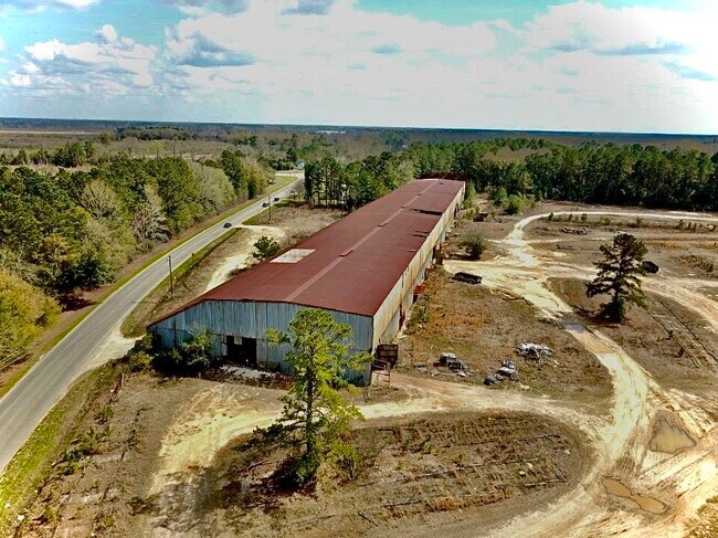
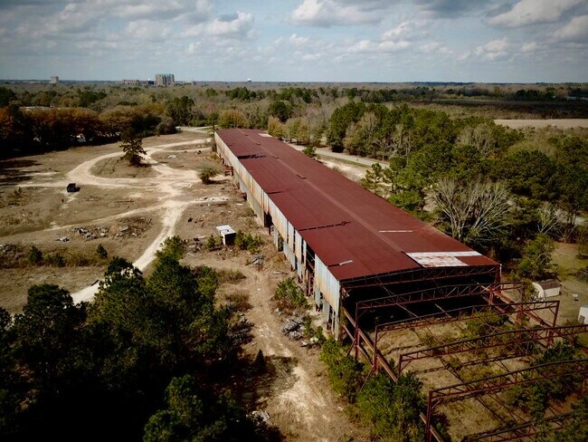
Property Record
1500 E National Cemetery Rd, Florence, SC 29506

NEARBY LISTINGS FOR SALE OR LEASE
Property Detail
1500 E National Cemetery Rd
00178-01-005
NATIONAL CEMETERY RD
Warehouse
Florence
X
South Carolina
45041C0161E
22.45 AC
2024
Florence/Dillon
2024
Other Market Areas
000502
Florence, SC
91,600 SF
DEMOGRAPHICS near 1500 E National Cemetery Rd
1 Mile
3 Mile
5 Mile
2024 Total Population
2,319
31,639
61,193
2029 Population
2,355
31,617
60,843
Pop Growth 2024-2029
+ 1.55%
(0.07%)
(0.57%)
Average Age
36
40
40
2024 Total Households
865
13,097
25,353
HH Growth 2024-2029
+ 1.73%
+ 0.06%
(0.56%)
Median Household Inc
$19,913
$40,285
$49,026
Avg Household Size
2.50
2.30
2.30
2024 Avg HH Vehicles
2.00
2.00
2.00
Median Home Value
$72,645
$147,515
$159,156
Median Year Built
1982
1975
1981
Nearby Places
Map Layers
Map Styles
 Street
 Aerial
- Restaurants
- Banks
- Shops
- Fitness
- Groceries
PUBLIC TRANSPORTATION
COMMUTER RAIL
Florence Amtrak Station (Palmetto - Amtrak, Silver Meteor - Amtrak)
DRIVE
WALK
Distance
Florence Amtrak Station (Palmetto - Amtrak, Silver Meteor - Amtrak)
6 min
1.8 mi
Freight Ports
North Charleston Terminal
DRIVE
WALK
Distance
North Charleston Terminal
141 min
102.7 mi
SALE & LEASE HISTORY
LISTING DATE
SALE/LEASE

Mar 11, 2020
For Sale
Nearby Properties
Address
Land Use
TOTAL SIZE
Lot Size
Zoning
Address
Land Use
TOTAL SIZE
Lot Size
Zoning
218,850 SF
7.54 AC
B3
Address
Land Use
TOTAL SIZE
Lot Size
Zoning
2,418 SF
23.31 AC
Address
Land Use
TOTAL SIZE
Lot Size
Zoning
8,416 SF
2.10 AC
B4
Address
Land Use
TOTAL SIZE
Lot Size
Zoning
125,000 SF
6.84 AC
B1
Address
Land Use
TOTAL SIZE
Lot Size
Zoning
1,347.68 AC
Address
Land Use
TOTAL SIZE
Lot Size
Zoning
86,950 SF
6.82 AC
B2
Address
Land Use
TOTAL SIZE
Lot Size
Zoning
55,536 SF
0.02 AC
Address
Land Use
TOTAL SIZE
Lot Size
Zoning
55,536 SF
0.02 AC
Address
Land Use
TOTAL SIZE
Lot Size
Zoning
133,616 SF
10.98 AC
Address
Land Use
TOTAL SIZE
Lot Size
Zoning
26.36 AC
B1
Address
Land Use
TOTAL SIZE
Lot Size
Zoning
79,263 SF
1.34 AC
B4
Address
Land Use
TOTAL SIZE
Lot Size
Zoning
134,869 SF
20.08 AC
Address
Land Use
TOTAL SIZE
Lot Size
Zoning
60,000 SF
0.02 AC
Address
Land Use
TOTAL SIZE
Lot Size
Zoning
71,400 SF
3.71 AC
B3
Address
Land Use
TOTAL SIZE
Lot Size
Zoning
14,820 SF
0.88 AC
B3
Address
Land Use
TOTAL SIZE
Lot Size
Zoning
47,600 SF
4.57 AC
R4
Address
Land Use
TOTAL SIZE
Lot Size
Zoning
112,056 SF
18.96 AC
Address
Land Use
TOTAL SIZE
Lot Size
Zoning
60,575 SF
5.65 AC
Address
Land Use
TOTAL SIZE
Lot Size
Zoning
30.32 AC
Address
Land Use
TOTAL SIZE
Lot Size
Zoning
2.39 AC
B1
Address
Land Use
TOTAL SIZE
Lot Size
Zoning
64,416 SF
3.29 AC
B4
Address
Land Use
TOTAL SIZE
Lot Size
Zoning
59,361 SF
9.14 AC
Address
Land Use
TOTAL SIZE
Lot Size
Zoning
47,905 SF
7.02 AC
Address
Land Use
TOTAL SIZE
Lot Size
Zoning
14,950 SF
1.41 AC
B3
Address
Land Use
TOTAL SIZE
Lot Size
Zoning
18,908 SF
0.47 AC
B3
Address
Land Use
TOTAL SIZE
Lot Size
Zoning
22,464 SF
4.46 AC
Address
Land Use
TOTAL SIZE
Lot Size
Zoning
14,024 SF
2 AC
Address
Land Use
TOTAL SIZE
Lot Size
Zoning
22,242 SF
0.15 AC
B4
The World's #1 Commercial Real Estate Marketplace
Connect with us
© 2026 CoStar Group
The information above has been obtained from sources believed reliable. While we do not doubt its accuracy we have not verified it and make no guarantee, warranty or representation about it. It is your responsibility to independently confirm its accuracy and completeness. Any projections, opinions, assumptions, or estimates used are for example only and do not represent the current or future performance of the property. The value of this transaction to you depends on tax and other factors which should be evaluated by your tax, financial, and legal advisors. You and your advisors should conduct a careful, independent investigation of the property to determine to your satisfaction the suitability of the property for your needs.