Property Record
1500 Elida Rd, Lima, OH 45805
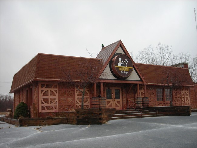

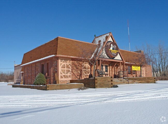
Property Detail
1500 Elida Rd
Lima, OH
NORWOOD ESTATES LOTS 16041 THRU 16047-HWY
36-26-08-03-002.000
ALLEN
Industrialgeneral
Ohio
B and X Area of moderate flood hazard, usually the area between the limits of the 100-year and 500-year floods.
16041
2024
1.73 AC
2024
Lima/Findlay
011000
Other Market Areas
35,000 SF
NEARBY LISTINGS FOR SALE OR LEASE
DEMOGRAPHICS near 1500 Elida Rd
1 mile
3 mile
5 mile
2025 Total Population
8,694
44,484
66,683
2030 Population
8,668
44,378
66,417
Pop Growth 2025-2030
(0.30%)
(0.24%)
(0.40%)
Average Age
40
40
40
2025 Total Households
3,966
18,261
27,103
HH Growth 2025-2030
(0.25%)
(0.32%)
(0.49%)
Median Household Inc
$51,245
$52,705
$60,857
Avg Household Size
2.10
2.20
2.30
2025 Avg HH Vehicles
2.00
2.00
2.00
Median Home Value
$126,720
$139,957
$163,892
Median Year Built
1965
1960
1963
Nearby Places
Map Layers
Map Styles
 Street
 Aerial
Transit
 Traffic
 Biking
Places
Listings with unknown addresses are not visible on the map
- Restaurants
- Banks
- Shops
- Fitness
- Groceries
Nearby Properties
Address
Land Use
TOTAL SIZE
Lot Size
Zoning
Address
Land Use
TOTAL SIZE
Lot Size
Zoning
628,932 SF
9.08 AC
Address
Land Use
TOTAL SIZE
Lot Size
Zoning
359,238 SF
9.72 AC
Address
Land Use
TOTAL SIZE
Lot Size
Zoning
242,023 SF
3.81 AC
Address
Land Use
TOTAL SIZE
Lot Size
Zoning
387.31 AC
Address
Land Use
TOTAL SIZE
Lot Size
Zoning
285,016 SF
31.90 AC
Address
Land Use
TOTAL SIZE
Lot Size
Zoning
209,864 SF
87.96 AC
Address
Land Use
TOTAL SIZE
Lot Size
Zoning
5,520 SF
12.99 AC
Address
Land Use
TOTAL SIZE
Lot Size
Zoning
75,197 SF
45.82 AC
Address
Land Use
TOTAL SIZE
Lot Size
Zoning
523,578 SF
468.55 AC
Address
Land Use
TOTAL SIZE
Lot Size
Zoning
74.59 AC
Address
Land Use
TOTAL SIZE
Lot Size
Zoning
131,584 SF
32.09 AC
Address
Land Use
TOTAL SIZE
Lot Size
Zoning
104,798 SF
0.94 AC
Address
Land Use
TOTAL SIZE
Lot Size
Zoning
269.47 AC
Address
Land Use
TOTAL SIZE
Lot Size
Zoning
62,626 SF
5.16 AC
Address
Land Use
TOTAL SIZE
Lot Size
Zoning
16,992 SF
21.86 AC
Address
Land Use
TOTAL SIZE
Lot Size
Zoning
652,254 SF
46.12 AC
Address
Land Use
TOTAL SIZE
Lot Size
Zoning
134,124 SF
29.04 AC
Address
Land Use
TOTAL SIZE
Lot Size
Zoning
253,944 SF
27.50 AC
Address
Land Use
TOTAL SIZE
Lot Size
Zoning
177,998 SF
22.49 AC
Address
Land Use
TOTAL SIZE
Lot Size
Zoning
585,479 SF
28.85 AC
Address
Land Use
TOTAL SIZE
Lot Size
Zoning
50,497 SF
38.72 AC
Address
Land Use
TOTAL SIZE
Lot Size
Zoning
92.37 AC
Address
Land Use
TOTAL SIZE
Lot Size
Zoning
70,067 SF
9.50 AC
Address
Land Use
TOTAL SIZE
Lot Size
Zoning
101,362 SF
2.78 AC
Address
Land Use
TOTAL SIZE
Lot Size
Zoning
80,130 SF
6.69 AC
Address
Land Use
TOTAL SIZE
Lot Size
Zoning
204,050 SF
43.36 AC
Address
Land Use
TOTAL SIZE
Lot Size
Zoning
62,566 SF
13 AC
Address
Land Use
TOTAL SIZE
Lot Size
Zoning
65,986 SF
6.50 AC
Address
Land Use
TOTAL SIZE
Lot Size
Zoning
87,128 SF
1.89 AC
Address
Land Use
TOTAL SIZE
Lot Size
Zoning
171,264 SF
22.05 AC
The World's #1 Commercial Real Estate Marketplace
Connect with us
© 2026 CoStar Group
The information above has been obtained from sources believed reliable. While we do not doubt its accuracy we have not verified it and make no guarantee, warranty or representation about it. It is your responsibility to independently confirm its accuracy and completeness. Any projections, opinions, assumptions, or estimates used are for example only and do not represent the current or future performance of the property. The value of this transaction to you depends on tax and other factors which should be evaluated by your tax, financial, and legal advisors. You and your advisors should conduct a careful, independent investigation of the property to determine to your satisfaction the suitability of the property for your needs.