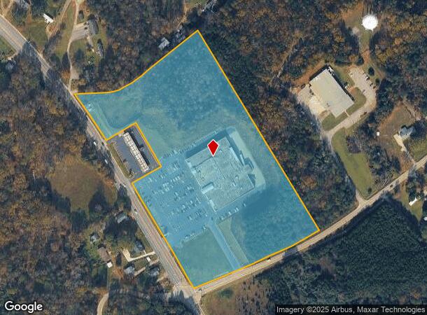
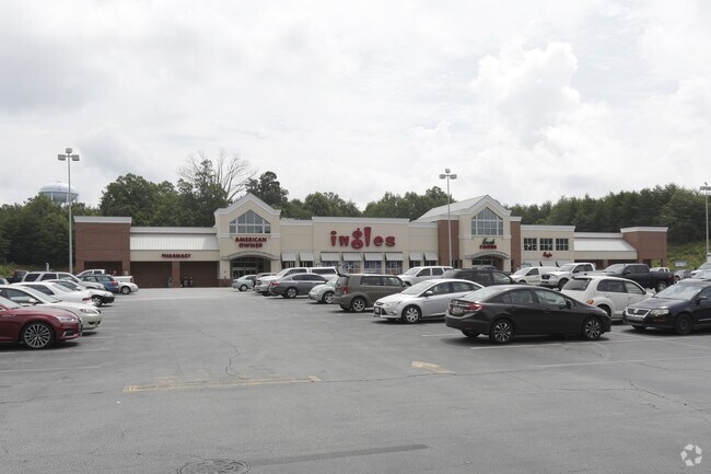
Property Record
1500 Geer Hwy, Travelers Rest, SC 29690

NEARBY LISTINGS FOR SALE OR LEASE
Property Detail
1500 Geer Hwy
Greenville-Anderson-Mauldin, SC
MAP 0505.04
0505.04-01-013.01
Greenville
Supermarket
South Carolina
X
013.01
45045C0302E
14.17 AC
2024
Travelers Rest
2024
Greenville/Spartanburg
003903
DEMOGRAPHICS near 1500 Geer Hwy
1 Mile
3 Mile
5 Mile
2024 Total Population
1,589
12,014
29,453
2029 Population
1,754
13,310
32,407
Pop Growth 2024-2029
+ 10.38%
+ 10.79%
+ 10.03%
Average Age
41
41
41
2024 Total Households
609
4,671
10,780
HH Growth 2024-2029
+ 10.51%
+ 10.90%
+ 10.54%
Median Household Inc
$56,351
$48,458
$58,613
Avg Household Size
2.50
2.50
2.50
2024 Avg HH Vehicles
2.00
2.00
2.00
Median Home Value
$249,056
$244,307
$253,962
Median Year Built
1990
1991
1992
Nearby Places
- Restaurants
- Banks
- Shops
- Fitness
- Groceries
PUBLIC TRANSPORTATION
AIRPORT
Greenville Spartanburg International
DRIVE
WALK
Distance
Greenville Spartanburg International
42 min
24.3 mi
Freight Ports
North Charleston Terminal
DRIVE
WALK
Distance
North Charleston Terminal
249 min
214.9 mi
Nearby Properties
Address
Land Use
TOTAL SIZE
Lot Size
Zoning
Address
Land Use
TOTAL SIZE
Lot Size
Zoning
3.93 AC
R10
Address
Land Use
TOTAL SIZE
Lot Size
Zoning
14.40 AC
I1
Address
Land Use
TOTAL SIZE
Lot Size
Zoning
Address
Land Use
TOTAL SIZE
Lot Size
Zoning
6.22 AC
I1
Address
Land Use
TOTAL SIZE
Lot Size
Zoning
4.97 AC
C2
Address
Land Use
TOTAL SIZE
Lot Size
Zoning
9.60 AC
I1
Address
Land Use
TOTAL SIZE
Lot Size
Zoning
35 AC
C2
Address
Land Use
TOTAL SIZE
Lot Size
Zoning
11.56 AC
I1
Address
Land Use
TOTAL SIZE
Lot Size
Zoning
24.45 AC
I1
Address
Land Use
TOTAL SIZE
Lot Size
Zoning
1.26 AC
RS
Address
Land Use
TOTAL SIZE
Lot Size
Zoning
2.58 AC
PDR
Address
Land Use
TOTAL SIZE
Lot Size
Zoning
15.31 AC
UNZONED
Address
Land Use
TOTAL SIZE
Lot Size
Zoning
9.31 AC
UNZONED
Address
Land Use
TOTAL SIZE
Lot Size
Zoning
4.40 AC
I1
Address
Land Use
TOTAL SIZE
Lot Size
Zoning
58.70 AC
R75
Address
Land Use
TOTAL SIZE
Lot Size
Zoning
19.60 AC
NZ
Address
Land Use
TOTAL SIZE
Lot Size
Zoning
1.10 AC
UNZONED
Address
Land Use
TOTAL SIZE
Lot Size
Zoning
14.01 AC
C2
Address
Land Use
TOTAL SIZE
Lot Size
Zoning
40.21 AC
UNZONED
Address
Land Use
TOTAL SIZE
Lot Size
Zoning
13 AC
I1
Address
Land Use
TOTAL SIZE
Lot Size
Zoning
9.70 AC
RS
Address
Land Use
TOTAL SIZE
Lot Size
Zoning
1.56 AC
C1
Address
Land Use
TOTAL SIZE
Lot Size
Zoning
10.60 AC
RS
Address
Land Use
TOTAL SIZE
Lot Size
Zoning
24.64 AC
UNZONED
Address
Land Use
TOTAL SIZE
Lot Size
Zoning
69 AC
PUD
Address
Land Use
TOTAL SIZE
Lot Size
Zoning
8.90 AC
S1
Address
Land Use
TOTAL SIZE
Lot Size
Zoning
2.12 AC
C2
Address
Land Use
TOTAL SIZE
Lot Size
Zoning
4.29 AC
UNZONED
Address
Land Use
TOTAL SIZE
Lot Size
Zoning
7.48 AC
C2
Address
Land Use
TOTAL SIZE
Lot Size
Zoning
23.50 AC
UNZONED
The World's #1 Commercial Real Estate Marketplace
Connect with us
© 2025 CoStar Group
The information above has been obtained from sources believed reliable. While we do not doubt its accuracy we have not verified it and make no guarantee, warranty or representation about it. It is your responsibility to independently confirm its accuracy and completeness. Any projections, opinions, assumptions, or estimates used are for example only and do not represent the current or future performance of the property. The value of this transaction to you depends on tax and other factors which should be evaluated by your tax, financial, and legal advisors. You and your advisors should conduct a careful, independent investigation of the property to determine to your satisfaction the suitability of the property for your needs.