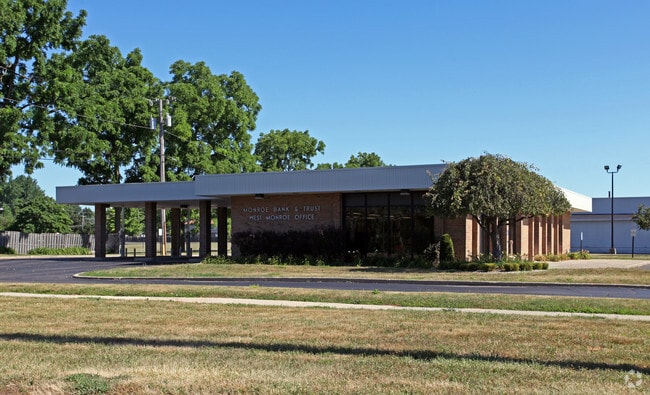
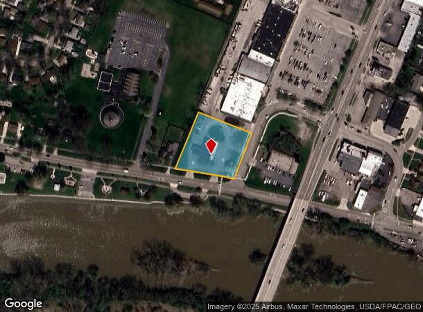
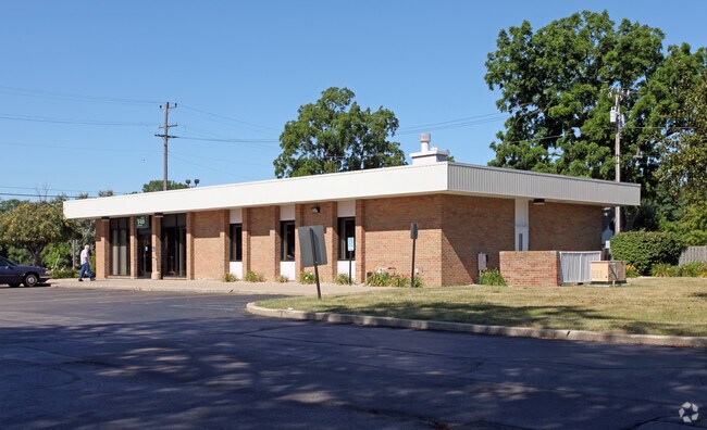
Property Record
1500 N Custer Rd, Monroe, MI 48162
NEARBY LISTINGS FOR SALE OR LEASE
Property Detail
1500 N Custer Rd
Monroe, MI
Suprvrs 1 - Monroe City
55-69-00659-054
SUPERVISORS PLAT NO 1 COMM AT A PT IN N R/O/W LI N CUSTER RD SD POINT BEING 50.62 FT N 23D 39M 03S E AND 33.41 FT N 75D 18M
Centrallyassessed
Monroe
AE
Michigan
26115C0241E
109
2024
1.28 AC
2025
Monroe County
831400
Detroit
2,812 SF
DEMOGRAPHICS near 1500 N Custer Rd
1 Mile
3 Mile
5 Mile
2024 Total Population
10,475
42,230
52,962
2029 Population
10,569
42,904
53,829
Pop Growth 2024-2029
+ 0.90%
+ 1.60%
+ 1.64%
Average Age
42
41
42
2024 Total Households
4,587
17,432
21,641
HH Growth 2024-2029
+ 0.87%
+ 1.51%
+ 1.56%
Median Household Inc
$53,826
$57,506
$61,143
Avg Household Size
2.20
2.30
2.30
2024 Avg HH Vehicles
2.00
2.00
2.00
Median Home Value
$150,813
$160,543
$169,480
Median Year Built
1962
1967
1968
Nearby Places
Map Layers
Map Styles
 Street
 Aerial
- Restaurants
- Banks
- Shops
- Fitness
- Groceries
PUBLIC TRANSPORTATION
AIRPORT
Detroit Metro Wayne County
DRIVE
WALK
Distance
Detroit Metro Wayne County
36 min
24.5 mi
Eugene F Kranz Toledo Express
DRIVE
WALK
Distance
Eugene F Kranz Toledo Express
63 min
40.6 mi
Windsor International
DRIVE
WALK
Distance
Windsor International
69 min
46.8 mi
Freight Ports
DRIVE
WALK
Distance
39 min
24.7 mi
Nearby Properties
Address
Land Use
TOTAL SIZE
Lot Size
Zoning
Address
Land Use
TOTAL SIZE
Lot Size
Zoning
200,000 SF
94.63 AC
CO
Address
Land Use
TOTAL SIZE
Lot Size
Zoning
409,765 SF
41.46 AC
Address
Land Use
TOTAL SIZE
Lot Size
Zoning
95.60 AC
Address
Land Use
TOTAL SIZE
Lot Size
Zoning
195,744 SF
32.62 AC
C-2-COMMER
Address
Land Use
TOTAL SIZE
Lot Size
Zoning
3.97 AC
Address
Land Use
TOTAL SIZE
Lot Size
Zoning
13.60 AC
Address
Land Use
TOTAL SIZE
Lot Size
Zoning
43,528 SF
16.06 AC
MHP
Address
Land Use
TOTAL SIZE
Lot Size
Zoning
317,482 SF
20.53 AC
Address
Land Use
TOTAL SIZE
Lot Size
Zoning
2,195 SF
86.71 AC
MHP
Address
Land Use
TOTAL SIZE
Lot Size
Zoning
192,917 SF
15.81 AC
R3B-MULTIF
Address
Land Use
TOTAL SIZE
Lot Size
Zoning
69,590 SF
11.55 AC
C-2-COMMER
Address
Land Use
TOTAL SIZE
Lot Size
Zoning
148,343 SF
15.15 AC
Address
Land Use
TOTAL SIZE
Lot Size
Zoning
3,822 SF
16.60 AC
R-1A
Address
Land Use
TOTAL SIZE
Lot Size
Zoning
138,119 SF
15.12 AC
Address
Land Use
TOTAL SIZE
Lot Size
Zoning
189,314 SF
28.56 AC
Address
Land Use
TOTAL SIZE
Lot Size
Zoning
94,324 SF
10.11 AC
Address
Land Use
TOTAL SIZE
Lot Size
Zoning
142,400 SF
15.20 AC
Address
Land Use
TOTAL SIZE
Lot Size
Zoning
41 AC
MHP
Address
Land Use
TOTAL SIZE
Lot Size
Zoning
412,877 SF
22.35 AC
R-1A
Address
Land Use
TOTAL SIZE
Lot Size
Zoning
200,700 SF
9.95 AC
R-1A
Address
Land Use
TOTAL SIZE
Lot Size
Zoning
31.45 AC
Address
Land Use
TOTAL SIZE
Lot Size
Zoning
149,282 SF
7.57 AC
R-1A
Address
Land Use
TOTAL SIZE
Lot Size
Zoning
13.38 AC
Address
Land Use
TOTAL SIZE
Lot Size
Zoning
75,437 SF
8.74 AC
R-1A
Address
Land Use
TOTAL SIZE
Lot Size
Zoning
6.78 AC
Address
Land Use
TOTAL SIZE
Lot Size
Zoning
109,626 SF
8.89 AC
Address
Land Use
TOTAL SIZE
Lot Size
Zoning
975 SF
34.50 AC
MHP
Address
Land Use
TOTAL SIZE
Lot Size
Zoning
85,062 SF
9.32 AC
Address
Land Use
TOTAL SIZE
Lot Size
Zoning
Address
Land Use
TOTAL SIZE
Lot Size
Zoning
150,200 SF
5.68 AC
R-1A
The World's #1 Commercial Real Estate Marketplace
Connect with us
© 2025 CoStar Group
The information above has been obtained from sources believed reliable. While we do not doubt its accuracy we have not verified it and make no guarantee, warranty or representation about it. It is your responsibility to independently confirm its accuracy and completeness. Any projections, opinions, assumptions, or estimates used are for example only and do not represent the current or future performance of the property. The value of this transaction to you depends on tax and other factors which should be evaluated by your tax, financial, and legal advisors. You and your advisors should conduct a careful, independent investigation of the property to determine to your satisfaction the suitability of the property for your needs.