Property Record
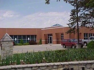
1500 Nw 7 Hwy, Blue Springs, MO 64014

NEARBY LISTINGS FOR SALE OR LEASE
Property Detail
1500 Nw 7 Hwy
36-420-02-12-00-0-00-000
SEC-30 TWP-49 RNG-30 PT NE 1/4 NW 1/4 DAF: BEG 973.88 S & 5 5.77 E OF NW COR NE 1/4 NW 1/4 TH N 286.33 TH E 248.83 TH S 285.36 TH W 239.83 TO POB
Financialbuilding
Jackson
X
Missouri
29095C0317G
1.66 AC
2024
East Jackson County
2025
Kansas City
014128
Kansas City, MO-KS
16,700 SF
DEMOGRAPHICS near 1500 Nw 7 Hwy
1 Mile
3 Mile
5 Mile
2024 Total Population
9,497
48,034
85,953
2029 Population
9,328
47,329
85,288
Pop Growth 2024-2029
(1.78%)
(1.47%)
(0.77%)
Average Age
40
39
39
2024 Total Households
3,550
17,872
32,247
HH Growth 2024-2029
(1.83%)
(1.57%)
(0.83%)
Median Household Inc
$84,013
$82,401
$82,495
Avg Household Size
2.60
2.60
2.60
2024 Avg HH Vehicles
2.00
2.00
2.00
Median Home Value
$240,550
$229,464
$237,809
Median Year Built
1982
1983
1990
Nearby Places
Map Layers
Map Styles
 Street
 Aerial
- Restaurants
- Banks
- Shops
- Fitness
- Groceries
PUBLIC TRANSPORTATION
AIRPORT
Kansas City International
DRIVE
WALK
Distance
Kansas City International
50 min
38.9 mi
Freight Ports
Tulsa Port Of Catoosa
DRIVE
WALK
Distance
Tulsa Port Of Catoosa
280 min
252.8 mi
SALE & LEASE HISTORY
LISTING DATE
SALE/LEASE

Sep 25, 2016
For Lease
Nearby Properties
Address
Land Use
TOTAL SIZE
Lot Size
Zoning
Address
Land Use
TOTAL SIZE
Lot Size
Zoning
292,760 SF
32.17 AC
Address
Land Use
TOTAL SIZE
Lot Size
Zoning
448,225 SF
38.38 AC
Address
Land Use
TOTAL SIZE
Lot Size
Zoning
228,168 SF
25.12 AC
Address
Land Use
TOTAL SIZE
Lot Size
Zoning
584,820 SF
38 AC
Address
Land Use
TOTAL SIZE
Lot Size
Zoning
255,288 SF
25.67 AC
Address
Land Use
TOTAL SIZE
Lot Size
Zoning
28,639 SF
10.40 AC
Address
Land Use
TOTAL SIZE
Lot Size
Zoning
120,053 SF
13.53 AC
Address
Land Use
TOTAL SIZE
Lot Size
Zoning
127,621 SF
23 AC
Address
Land Use
TOTAL SIZE
Lot Size
Zoning
214,518 SF
22.16 AC
Address
Land Use
TOTAL SIZE
Lot Size
Zoning
430,717 SF
69.75 AC
Address
Land Use
TOTAL SIZE
Lot Size
Zoning
129,570 SF
18.40 AC
Address
Land Use
TOTAL SIZE
Lot Size
Zoning
48,440 SF
21.49 AC
Address
Land Use
TOTAL SIZE
Lot Size
Zoning
71,169 SF
0.82 AC
Address
Land Use
TOTAL SIZE
Lot Size
Zoning
74,031 SF
0.02 AC
Address
Land Use
TOTAL SIZE
Lot Size
Zoning
96,371 SF
10.55 AC
Address
Land Use
TOTAL SIZE
Lot Size
Zoning
98,523 SF
9.48 AC
Address
Land Use
TOTAL SIZE
Lot Size
Zoning
42,176 SF
22.04 AC
Address
Land Use
TOTAL SIZE
Lot Size
Zoning
36,952 SF
20.90 AC
Address
Land Use
TOTAL SIZE
Lot Size
Zoning
93,336 SF
11.67 AC
Address
Land Use
TOTAL SIZE
Lot Size
Zoning
80,458 SF
0.40 AC
Address
Land Use
TOTAL SIZE
Lot Size
Zoning
48,270 SF
4.61 AC
Address
Land Use
TOTAL SIZE
Lot Size
Zoning
82,602 SF
8.80 AC
Address
Land Use
TOTAL SIZE
Lot Size
Zoning
49,601 SF
8.03 AC
Address
Land Use
TOTAL SIZE
Lot Size
Zoning
98,600 SF
4.50 AC
Address
Land Use
TOTAL SIZE
Lot Size
Zoning
130,178 SF
10.25 AC
Address
Land Use
TOTAL SIZE
Lot Size
Zoning
75,977 SF
8.86 AC
Address
Land Use
TOTAL SIZE
Lot Size
Zoning
36,000 SF
5.22 AC
Address
Land Use
TOTAL SIZE
Lot Size
Zoning
61,567 SF
10 AC
Address
Land Use
TOTAL SIZE
Lot Size
Zoning
80,774 SF
Address
Land Use
TOTAL SIZE
Lot Size
Zoning
88,112 SF
8.31 AC
The World's #1 Commercial Real Estate Marketplace
Connect with us
© 2025 CoStar Group
The information above has been obtained from sources believed reliable. While we do not doubt its accuracy we have not verified it and make no guarantee, warranty or representation about it. It is your responsibility to independently confirm its accuracy and completeness. Any projections, opinions, assumptions, or estimates used are for example only and do not represent the current or future performance of the property. The value of this transaction to you depends on tax and other factors which should be evaluated by your tax, financial, and legal advisors. You and your advisors should conduct a careful, independent investigation of the property to determine to your satisfaction the suitability of the property for your needs.