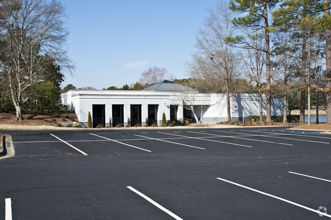
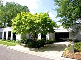
Property Record
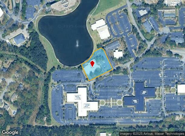
1500 Resource Dr, Birmingham, AL 35242
NEARBY LISTINGS FOR SALE OR LEASE
Property Detail
1500 Resource Dr
Birmingham-Hoover, AL
Meadow Brook Corp Park South Phase 2
09-3-06-0-001-001-108
SEC/TWNSHP/RAN 6 19S 01W NBRHD: 13 HOOVER COMMERCIAL-SMALL OFFICES R-2
Officebuilding
Shelby
X
Alabama
01117C0091E
8
2024
1.50 AC
2024
Hwy 280/Shelby County
030330
Birmingham
15,536 SF
DEMOGRAPHICS near 1500 Resource Dr
1 Mile
3 Mile
5 Mile
2024 Total Population
5,150
40,882
76,703
2029 Population
5,597
43,949
80,616
Pop Growth 2024-2029
+ 8.68%
+ 7.50%
+ 5.10%
Average Age
41
42
41
2024 Total Households
2,086
17,354
32,118
HH Growth 2024-2029
+ 8.82%
+ 7.47%
+ 4.93%
Median Household Inc
$110,465
$101,567
$103,422
Avg Household Size
2.40
2.30
2.30
2024 Avg HH Vehicles
2.00
2.00
2.00
Median Home Value
$370,854
$399,780
$395,632
Median Year Built
1991
1994
1994
Nearby Places
Map Layers
Map Styles
 Street
 Aerial
- Restaurants
- Banks
- Shops
- Fitness
- Groceries
PUBLIC TRANSPORTATION
AIRPORT
Birmingham-Shuttlesworth International
DRIVE
WALK
Distance
Birmingham-Shuttlesworth International
25 min
15.5 mi
SALE & LEASE HISTORY
LISTING DATE
SALE/LEASE

Sep 25, 2016
For Lease
May 30, 2019
For Lease
Jul 18, 2019
For Sale
Jul 18, 2019
For Sale
Nearby Properties
Address
Land Use
TOTAL SIZE
Lot Size
Zoning
Address
Land Use
TOTAL SIZE
Lot Size
Zoning
200,418 SF
6.50 AC
C1
Address
Land Use
TOTAL SIZE
Lot Size
Zoning
15,013 SF
79.12 AC
Address
Land Use
TOTAL SIZE
Lot Size
Zoning
153,413 SF
6.35 AC
C1
Address
Land Use
TOTAL SIZE
Lot Size
Zoning
6 AC
C-1
Address
Land Use
TOTAL SIZE
Lot Size
Zoning
4,674 SF
28.10 AC
Address
Land Use
TOTAL SIZE
Lot Size
Zoning
136,498 SF
11 AC
C1
Address
Land Use
TOTAL SIZE
Lot Size
Zoning
37,950 SF
26.50 AC
Address
Land Use
TOTAL SIZE
Lot Size
Zoning
30,967 SF
17.39 AC
Address
Land Use
TOTAL SIZE
Lot Size
Zoning
132,501 SF
50.39 AC
Address
Land Use
TOTAL SIZE
Lot Size
Zoning
235,082 SF
26.10 AC
C1
Address
Land Use
TOTAL SIZE
Lot Size
Zoning
102,373 SF
12.33 AC
R1-E
Address
Land Use
TOTAL SIZE
Lot Size
Zoning
4,335 SF
26.43 AC
Address
Land Use
TOTAL SIZE
Lot Size
Zoning
64,375 SF
8.99 AC
Address
Land Use
TOTAL SIZE
Lot Size
Zoning
11,058 SF
24.33 AC
Address
Land Use
TOTAL SIZE
Lot Size
Zoning
111,045 SF
25.72 AC
Address
Land Use
TOTAL SIZE
Lot Size
Zoning
59,454 SF
4.21 AC
C1
Address
Land Use
TOTAL SIZE
Lot Size
Zoning
11,492 SF
21.30 AC
Address
Land Use
TOTAL SIZE
Lot Size
Zoning
89,134 SF
6.50 AC
C-1
Address
Land Use
TOTAL SIZE
Lot Size
Zoning
2,404 SF
17.42 AC
Address
Land Use
TOTAL SIZE
Lot Size
Zoning
127,710 SF
31.82 AC
Address
Land Use
TOTAL SIZE
Lot Size
Zoning
5,506 SF
17.36 AC
Address
Land Use
TOTAL SIZE
Lot Size
Zoning
144,210 SF
9.37 AC
Address
Land Use
TOTAL SIZE
Lot Size
Zoning
4,259 SF
24.94 AC
Address
Land Use
TOTAL SIZE
Lot Size
Zoning
1,400 SF
21.35 AC
Address
Land Use
TOTAL SIZE
Lot Size
Zoning
16,187 SF
33.04 AC
Address
Land Use
TOTAL SIZE
Lot Size
Zoning
60,656 SF
20.32 AC
Address
Land Use
TOTAL SIZE
Lot Size
Zoning
7,861 SF
29 AC
Address
Land Use
TOTAL SIZE
Lot Size
Zoning
251,087 SF
23 AC
R-4
Address
Land Use
TOTAL SIZE
Lot Size
Zoning
220,128 SF
24.49 AC
The World's #1 Commercial Real Estate Marketplace
Connect with us
© 2025 CoStar Group
The information above has been obtained from sources believed reliable. While we do not doubt its accuracy we have not verified it and make no guarantee, warranty or representation about it. It is your responsibility to independently confirm its accuracy and completeness. Any projections, opinions, assumptions, or estimates used are for example only and do not represent the current or future performance of the property. The value of this transaction to you depends on tax and other factors which should be evaluated by your tax, financial, and legal advisors. You and your advisors should conduct a careful, independent investigation of the property to determine to your satisfaction the suitability of the property for your needs.