Property Record
1500 S 9Th St, Alhambra, CA 91803
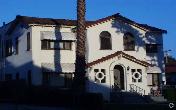


Property Detail
1500 S 9Th St
5357-002-012
TRACT NO 4704 LOT 68
Multifamilydwelling
Los Angeles
ALRPD*
California
B and X Area of moderate flood hazard, usually the area between the limits of the 100-year and 500-year floods.
68
2024
0.20 AC
2025
Alhambra
481606
Los Angeles
4,800 SF
Los Angeles-Long Beach-Glendale, CA
NEARBY LISTINGS FOR SALE OR LEASE
DEMOGRAPHICS near 1500 S 9Th St
1 mile
3 mile
5 mile
2025 Total Population
37,676
261,055
698,019
2030 Population
37,418
258,263
688,457
Pop Growth 2025-2030
(0.68%)
(1.07%)
(1.37%)
Average Age
43
42
41
2025 Total Households
12,854
86,506
228,548
HH Growth 2025-2030
(0.90%)
(1.29%)
(1.52%)
Median Household Inc
$72,673
$86,950
$85,938
Avg Household Size
2.80
2.90
2.90
2025 Avg HH Vehicles
2.00
2.00
2.00
Median Home Value
$805,440
$856,552
$858,211
Median Year Built
1964
1958
1957
Nearby Places
Map Layers
Map Styles
 Street
 Aerial
Transit
 Traffic
 Biking
Places
Listings with unknown addresses are not visible on the map
- Restaurants
- Banks
- Shops
- Fitness
- Groceries
PUBLIC TRANSPORTATION
COMMUTER RAIL
Montebello/Commerce (Riverside Line - Southern California Regional Rail Authority (Metrolink))
Drive
Walk
Distance
Montebello/Commerce (Riverside Line - Southern California Regional Rail Authority (Metrolink))
13 min
6.0 mi
AIRPORT
Bob Hope
Drive
Walk
Distance
Bob Hope
29 min
21.6 mi
Long Beach (Daugherty Field)
Drive
Walk
Distance
Long Beach (Daugherty Field)
32 min
21.9 mi
Los Angeles International
Drive
Walk
Distance
Los Angeles International
35 min
23.0 mi
Freight Ports
Port of Long Beach
Drive
Walk
Distance
Port of Long Beach
33 min
24.8 mi
Nearby Properties
Address
Land Use
TOTAL SIZE
Lot Size
Zoning
Address
Land Use
TOTAL SIZE
Lot Size
Zoning
460,590 SF
23.95 AC
ALMPD*
Address
Land Use
TOTAL SIZE
Lot Size
Zoning
516,474 SF
4.37 AC
ALCBD/DRD*
Address
Land Use
TOTAL SIZE
Lot Size
Zoning
247,960 SF
1.99 AC
SLC3
Address
Land Use
TOTAL SIZE
Lot Size
Zoning
593,133 SF
SLR1YY
Address
Land Use
TOTAL SIZE
Lot Size
Zoning
151,450 SF
6.59 AC
MPSP*
Address
Land Use
TOTAL SIZE
Lot Size
Zoning
220,717 SF
2.14 AC
MPSP*
Address
Land Use
TOTAL SIZE
Lot Size
Zoning
220,142 SF
9.92 AC
SLR1VV
Address
Land Use
TOTAL SIZE
Lot Size
Zoning
198,728 SF
2.50 AC
SLR3YY
Address
Land Use
TOTAL SIZE
Lot Size
Zoning
116,480 SF
11.81 AC
MPC2
Address
Land Use
TOTAL SIZE
Lot Size
Zoning
621,229 SF
7.98 AC
MPM*
Address
Land Use
TOTAL SIZE
Lot Size
Zoning
331,660 SF
7.34 AC
RMC3*
Address
Land Use
TOTAL SIZE
Lot Size
Zoning
320,844 SF
6.45 AC
SLCHR*
Address
Land Use
TOTAL SIZE
Lot Size
Zoning
77,778 SF
2.87 AC
ALRPD*
Address
Land Use
TOTAL SIZE
Lot Size
Zoning
203,491 SF
15.84 AC
MPM*
Address
Land Use
TOTAL SIZE
Lot Size
Zoning
66,102 SF
1.90 AC
MPCM*
Address
Land Use
TOTAL SIZE
Lot Size
Zoning
85,890 SF
2.33 AC
MPR2SCH*
Address
Land Use
TOTAL SIZE
Lot Size
Zoning
130,189 SF
6.59 AC
MPOPCD*
Address
Land Use
TOTAL SIZE
Lot Size
Zoning
146,264 SF
1.87 AC
LAMR1
Address
Land Use
TOTAL SIZE
Lot Size
Zoning
288,700 SF
6.19 AC
MPOP*
Address
Land Use
TOTAL SIZE
Lot Size
Zoning
155,339 SF
3.99 AC
LAMR1
Address
Land Use
TOTAL SIZE
Lot Size
Zoning
203,860 SF
1.92 AC
MPSP*
Address
Land Use
TOTAL SIZE
Lot Size
Zoning
48,018 SF
2.64 AC
SLC3*
Address
Land Use
TOTAL SIZE
Lot Size
Zoning
119,883 SF
5.93 AC
MPOP*
Address
Land Use
TOTAL SIZE
Lot Size
Zoning
54,368 SF
1.20 AC
SLR3YY
Address
Land Use
TOTAL SIZE
Lot Size
Zoning
82,188 SF
1.20 AC
ALCBD/DRD*
Address
Land Use
TOTAL SIZE
Lot Size
Zoning
121,733 SF
5.59 AC
ALMPD*
Address
Land Use
TOTAL SIZE
Lot Size
Zoning
41,761 SF
3.25 AC
ALCPD-R1*
Address
Land Use
TOTAL SIZE
Lot Size
Zoning
60,919 SF
1.47 AC
SLR3YY
Address
Land Use
TOTAL SIZE
Lot Size
Zoning
170,198 SF
3.84 AC
MPOP
Address
Land Use
TOTAL SIZE
Lot Size
Zoning
96,575 SF
9.18 AC
LAMR1
The World's #1 Commercial Real Estate Marketplace
Connect with us
© 2026 CoStar Group
The information above has been obtained from sources believed reliable. While we do not doubt its accuracy we have not verified it and make no guarantee, warranty or representation about it. It is your responsibility to independently confirm its accuracy and completeness. Any projections, opinions, assumptions, or estimates used are for example only and do not represent the current or future performance of the property. The value of this transaction to you depends on tax and other factors which should be evaluated by your tax, financial, and legal advisors. You and your advisors should conduct a careful, independent investigation of the property to determine to your satisfaction the suitability of the property for your needs.