Property Record
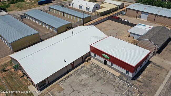
1500 Sw 3Rd Ave, Amarillo, TX 79106

Property Detail
1500 Sw 3Rd Ave
R-056-0100-1268-0
ORIG TOWN OF AMA, BLK 0019, LOTS 5 THRU 12 LESS THE N .6FT OF 5, 0.5260 ACRES
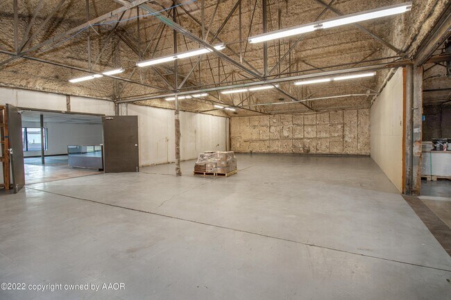
Officebuilding
Potter
I1
Texas
B and X Area of moderate flood hazard, usually the area between the limits of the 100-year and 500-year floods.
5-12
2024
0.53 AC
2025
Amarillo
012000
Other Market Areas
10,050 SF
Amarillo, TX
NEARBY LISTINGS FOR SALE OR LEASE
DEMOGRAPHICS near 1500 Sw 3Rd Ave
1 mile
3 mile
5 mile
2024 Total Population
7,179
67,045
155,722
2029 Population
7,299
67,076
157,324
Pop Growth 2024-2029
+ 1.67%
+ 0.05%
+ 1.03%
Average Age
39
38
38
2024 Total Households
3,090
26,581
61,289
HH Growth 2024-2029
+ 1.52%
0.00%
+ 1.12%
Median Household Inc
$39,096
$48,772
$54,641
Avg Household Size
2.20
2.40
2.40
2024 Avg HH Vehicles
1.00
2.00
2.00
Median Home Value
$98,946
$143,083
$167,117
Median Year Built
1951
1957
1967
Nearby Places
Map Layers
Map Styles
 Street
 Aerial
Transit
 Traffic
 Biking
Places
Listings with unknown addresses are not visible on the map
- Restaurants
- Banks
- Shops
- Fitness
- Groceries
PUBLIC TRANSPORTATION
AIRPORT
Rick Husband Amarillo International
Drive
Walk
Distance
Rick Husband Amarillo International
18 min
11.0 mi
SALE & LEASE HISTORY
LISTING DATE
SALE/LEASE

Sep 05, 2025
For Lease
Nearby Properties
Address
Land Use
TOTAL SIZE
Lot Size
Zoning
Address
Land Use
TOTAL SIZE
Lot Size
Zoning
431,320 SF
14.82 AC
1F2 S
Address
Land Use
TOTAL SIZE
Lot Size
Zoning
250,705 SF
2.07 AC
CB
Address
Land Use
TOTAL SIZE
Lot Size
Zoning
168,978 SF
4.23 AC
1F2 S
Address
Land Use
TOTAL SIZE
Lot Size
Zoning
350,459 SF
10.71 AC
Address
Land Use
TOTAL SIZE
Lot Size
Zoning
2,419 SF
8.93 AC
PD
Address
Land Use
TOTAL SIZE
Lot Size
Zoning
207,120 SF
16.54 AC
GR
Address
Land Use
TOTAL SIZE
Lot Size
Zoning
345,555 SF
23.69 AC
PD
Address
Land Use
TOTAL SIZE
Lot Size
Zoning
116,842 SF
4.17 AC
Address
Land Use
TOTAL SIZE
Lot Size
Zoning
45,380 SF
2.62 AC
Address
Land Use
TOTAL SIZE
Lot Size
Zoning
325,727 SF
26.09 AC
2F
Address
Land Use
TOTAL SIZE
Lot Size
Zoning
254,693 SF
5.24 AC
LC
Address
Land Use
TOTAL SIZE
Lot Size
Zoning
367,924 SF
39.99 AC
PD
Address
Land Use
TOTAL SIZE
Lot Size
Zoning
371,536 SF
2.07 AC
CB
Address
Land Use
TOTAL SIZE
Lot Size
Zoning
145,652 SF
20.53 AC
Address
Land Use
TOTAL SIZE
Lot Size
Zoning
133,279 SF
2.07 AC
CB
Address
Land Use
TOTAL SIZE
Lot Size
Zoning
229,869 SF
10.85 AC
Address
Land Use
TOTAL SIZE
Lot Size
Zoning
168,130 SF
16.32 AC
Address
Land Use
TOTAL SIZE
Lot Size
Zoning
100,350 SF
1.24 AC
CB
Address
Land Use
TOTAL SIZE
Lot Size
Zoning
125,357 SF
4.34 AC
LC
Address
Land Use
TOTAL SIZE
Lot Size
Zoning
99,739 SF
3.88 AC
R2
Address
Land Use
TOTAL SIZE
Lot Size
Zoning
80,476 SF
7.51 AC
I1
Address
Land Use
TOTAL SIZE
Lot Size
Zoning
388,909 SF
2.07 AC
CB
Address
Land Use
TOTAL SIZE
Lot Size
Zoning
77,549 SF
0.19 AC
CB
Address
Land Use
TOTAL SIZE
Lot Size
Zoning
110,796 SF
0.55 AC
MF2
Address
Land Use
TOTAL SIZE
Lot Size
Zoning
193,004 SF
Address
Land Use
TOTAL SIZE
Lot Size
Zoning
127,654 SF
5.73 AC
HC
Address
Land Use
TOTAL SIZE
Lot Size
Zoning
169,056 SF
2.35 AC
MF2
Address
Land Use
TOTAL SIZE
Lot Size
Zoning
132,914 SF
10.20 AC
PD
Address
Land Use
TOTAL SIZE
Lot Size
Zoning
128,891 SF
0.96 AC
CB
Address
Land Use
TOTAL SIZE
Lot Size
Zoning
205,577 SF
18.68 AC
I1
The World's #1 Commercial Real Estate Marketplace
Connect with us
© 2026 CoStar Group
The information above has been obtained from sources believed reliable. While we do not doubt its accuracy we have not verified it and make no guarantee, warranty or representation about it. It is your responsibility to independently confirm its accuracy and completeness. Any projections, opinions, assumptions, or estimates used are for example only and do not represent the current or future performance of the property. The value of this transaction to you depends on tax and other factors which should be evaluated by your tax, financial, and legal advisors. You and your advisors should conduct a careful, independent investigation of the property to determine to your satisfaction the suitability of the property for your needs.