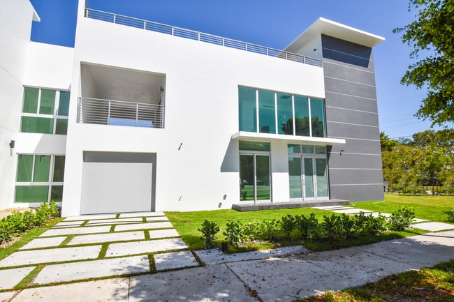
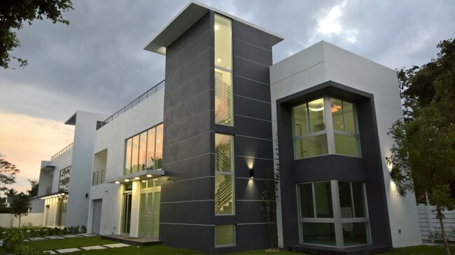
Property Record
1500 Sw 4Th Ave, Miami, FL 33129
NEARBY LISTINGS FOR SALE OR LEASE
Property Detail
1500 Sw 4Th Ave
Miami-Miami Beach-Kendall, FL
Brickell Broadway Villas
01-4138-172-0010
Miami/Dade
Condominium
Florida
X
Coral Way
12086C0314L
South Florida
2,827 SF
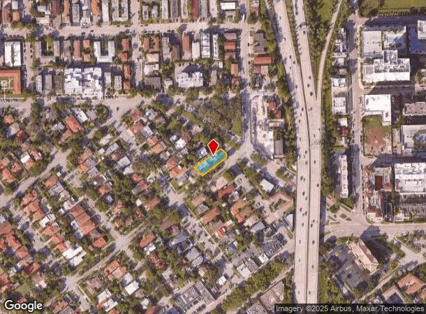
DEMOGRAPHICS near 1500 Sw 4Th Ave
1 Mile
3 Mile
5 Mile
2024 Total Population
76,681
252,020
492,249
2029 Population
76,666
250,189
489,056
Pop Growth 2024-2029
(0.02%)
(0.73%)
(0.65%)
Average Age
40
41
41
2024 Total Households
37,793
112,690
215,959
HH Growth 2024-2029
(0.50%)
(0.79%)
(0.57%)
Median Household Inc
$71,533
$56,798
$55,648
Avg Household Size
2.00
2.10
2.20
2024 Avg HH Vehicles
1.00
1.00
1.00
Median Home Value
$473,233
$474,906
$467,977
Median Year Built
2002
1992
1979
Nearby Places
Map Layers
Map Styles
 Street
 Aerial
- Restaurants
- Banks
- Shops
- Fitness
- Groceries
PUBLIC TRANSPORTATION
TRANSIT/SUBWAY
Brickell (Metromover) (Metromover Brickell Loop - Miami-Dade Transit (Metrorail/Metromover))
DRIVE
WALK
Distance
Brickell (Metromover) (Metromover Brickell Loop - Miami-Dade Transit (Metrorail/Metromover))
2 min
9 min
0.5 mi
Financial District (Metromover Brickell Loop - Miami-Dade Transit (Metrorail/Metromover))
DRIVE
WALK
Distance
Financial District (Metromover Brickell Loop - Miami-Dade Transit (Metrorail/Metromover))
2 min
11 min
0.6 mi
Tenth Street/Promenade (Metromover Brickell Loop - Miami-Dade Transit (Metrorail/Metromover))
DRIVE
WALK
Distance
Tenth Street/Promenade (Metromover Brickell Loop - Miami-Dade Transit (Metrorail/Metromover))
2 min
13 min
0.7 mi
Eighth Street (Metromover Brickell Loop - Miami-Dade Transit (Metrorail/Metromover))
DRIVE
WALK
Distance
Eighth Street (Metromover Brickell Loop - Miami-Dade Transit (Metrorail/Metromover))
2 min
16 min
0.9 mi
Fifth Street (Metromover Brickell Loop - Miami-Dade Transit (Metrorail/Metromover))
DRIVE
WALK
Distance
Fifth Street (Metromover Brickell Loop - Miami-Dade Transit (Metrorail/Metromover))
3 min
18 min
1.0 mi
COMMUTER RAIL
Brickell (Metrorail) (Metrorail Green Line - Miami-Dade Transit (Metrorail/Metromover))
DRIVE
WALK
Distance
Brickell (Metrorail) (Metrorail Green Line - Miami-Dade Transit (Metrorail/Metromover))
3 min
10 min
0.5 mi
Government Center (Metromover Brickell Loop - Miami-Dade Transit (Metrorail/Metromover), Metromover Downtown Loop - Miami-Dade Transit (Metrorail/Metromover), Metromover Omni Loop - Miami-Dade Transit (Metrorail/Metromover), Metrorail Green Line - Miami-Dade Transit (Metrorail/Metromover))
DRIVE
WALK
Distance
Government Center (Metromover Brickell Loop - Miami-Dade Transit (Metrorail/Metromover), Metromover Downtown Loop - Miami-Dade Transit (Metrorail/Metromover), Metromover Omni Loop - Miami-Dade Transit (Metrorail/Metromover), Metrorail Green Line - Miami-Dade Transit (Metrorail/Metromover))
4 min
1.8 mi
AIRPORT
Miami International
DRIVE
WALK
Distance
Miami International
24 min
12.5 mi
Fort Lauderdale/Hollywood International
DRIVE
WALK
Distance
Fort Lauderdale/Hollywood International
35 min
24.2 mi
Freight Ports
Port of Miami
DRIVE
WALK
Distance
Port of Miami
11 min
4.0 mi
SALE & LEASE HISTORY
LISTING DATE
SALE/LEASE

Jun 06, 2018
For Sale
Nearby Properties
Address
Land Use
TOTAL SIZE
Lot Size
Zoning
Address
Land Use
TOTAL SIZE
Lot Size
Zoning
1,050,691 SF
0.83 AC
6408
Address
Land Use
TOTAL SIZE
Lot Size
Zoning
4,758,614 SF
810.91 AC
8000
Address
Land Use
TOTAL SIZE
Lot Size
Zoning
955,966 SF
38.91 AC
9600
Address
Land Use
TOTAL SIZE
Lot Size
Zoning
2,559,318 SF
2.21 AC
6407
Address
Land Use
TOTAL SIZE
Lot Size
Zoning
2,039,308 SF
2.46 AC
6401
Address
Land Use
TOTAL SIZE
Lot Size
Zoning
928,000 SF
14.30 AC
8000
Address
Land Use
TOTAL SIZE
Lot Size
Zoning
1,110,657 SF
3.83 AC
6407
Address
Land Use
TOTAL SIZE
Lot Size
Zoning
1,346,294 SF
1.89 AC
6408
Address
Land Use
TOTAL SIZE
Lot Size
Zoning
2,403,353 SF
7.37 AC
6100
Address
Land Use
TOTAL SIZE
Lot Size
Zoning
1,162,113 SF
1.92 AC
6407
Address
Land Use
TOTAL SIZE
Lot Size
Zoning
1,075,124 SF
1.61 AC
6405
Address
Land Use
TOTAL SIZE
Lot Size
Zoning
1,544,491 SF
0.97 AC
6401
Address
Land Use
TOTAL SIZE
Lot Size
Zoning
782,686 SF
0.06 AC
6401
Address
Land Use
TOTAL SIZE
Lot Size
Zoning
1,657,362 SF
1.15 AC
6401
Address
Land Use
TOTAL SIZE
Lot Size
Zoning
1,072,012 SF
1.78 AC
6407
Address
Land Use
TOTAL SIZE
Lot Size
Zoning
244,533 SF
3.53 AC
6600
Address
Land Use
TOTAL SIZE
Lot Size
Zoning
694,863 SF
1.90 AC
6407
Address
Land Use
TOTAL SIZE
Lot Size
Zoning
656,821 SF
2.06 AC
6407
Address
Land Use
TOTAL SIZE
Lot Size
Zoning
303,989 SF
1.47 AC
6600
Address
Land Use
TOTAL SIZE
Lot Size
Zoning
416,675 SF
6.48 AC
6401
Address
Land Use
TOTAL SIZE
Lot Size
Zoning
1,004,006 SF
0.92 AC
6401
Address
Land Use
TOTAL SIZE
Lot Size
Zoning
2.50 AC
6407
Address
Land Use
TOTAL SIZE
Lot Size
Zoning
585,775 SF
1.86 AC
6101
Address
Land Use
TOTAL SIZE
Lot Size
Zoning
491,308 SF
0.14 AC
6401
Address
Land Use
TOTAL SIZE
Lot Size
Zoning
903,993 SF
0.60 AC
6412
Address
Land Use
TOTAL SIZE
Lot Size
Zoning
872,245 SF
0.56 AC
6401
Address
Land Use
TOTAL SIZE
Lot Size
Zoning
727,757 SF
0.64 AC
6408
Address
Land Use
TOTAL SIZE
Lot Size
Zoning
2 AC
8000
Address
Land Use
TOTAL SIZE
Lot Size
Zoning
1,101,032 SF
5.18 AC
8000
Address
Land Use
TOTAL SIZE
Lot Size
Zoning
1,262,330 SF
1.39 AC
6402
The World's #1 Commercial Real Estate Marketplace
Connect with us
© 2025 CoStar Group
The information above has been obtained from sources believed reliable. While we do not doubt its accuracy we have not verified it and make no guarantee, warranty or representation about it. It is your responsibility to independently confirm its accuracy and completeness. Any projections, opinions, assumptions, or estimates used are for example only and do not represent the current or future performance of the property. The value of this transaction to you depends on tax and other factors which should be evaluated by your tax, financial, and legal advisors. You and your advisors should conduct a careful, independent investigation of the property to determine to your satisfaction the suitability of the property for your needs.