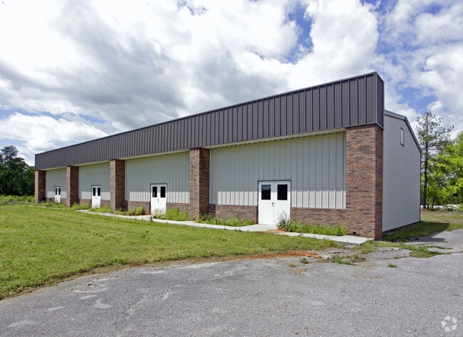
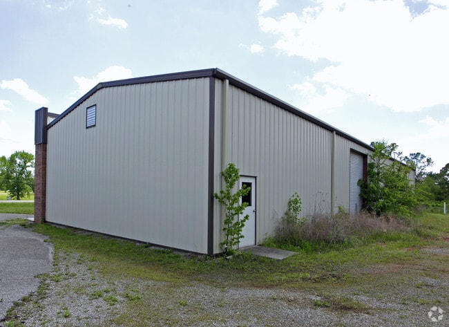
Property Record
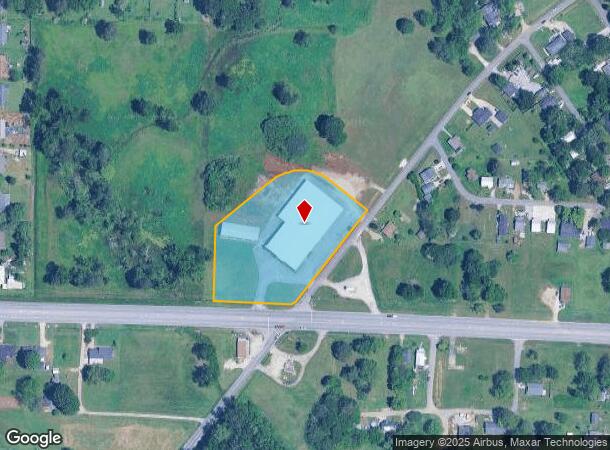
1500 Us Highway 72 W, Athens, AL 35611
NEARBY LISTINGS FOR SALE OR LEASE
-
-
View all Athens listings for sale on LoopNet.com
Property Detail
1500 Us Highway 72 W
10-03-07-4-007-031.001
Belmont Sub
Warehouse
COMM NW COR OF SW/4 OF SE/4 S 390 POB E 982 S 381 SE 204 TO NW ROW OF BROWNS FERRY ST TH SW 516 W 857 ALG N ROW OF HWY 72 TH
X
Limestone
01083C0186F
Alabama
2025
3.32 AC
2025
Athens
020500
Huntsville
30,480 SF
Huntsville, AL
DEMOGRAPHICS near 1500 Us Highway 72 W
1 Mile
3 Mile
5 Mile
2024 Total Population
4,890
20,529
35,668
2029 Population
5,704
24,092
42,009
Pop Growth 2024-2029
+ 16.65%
+ 17.36%
+ 17.78%
Average Age
44
41
41
2024 Total Households
2,013
8,465
14,447
HH Growth 2024-2029
+ 17.04%
+ 17.86%
+ 18.26%
Median Household Inc
$41,618
$43,995
$52,024
Avg Household Size
2.20
2.30
2.40
2024 Avg HH Vehicles
2.00
2.00
2.00
Median Home Value
$152,464
$170,355
$200,226
Median Year Built
1981
1978
1984
Nearby Places
Map Layers
Map Styles
 Street
 Aerial
- Restaurants
- Banks
- Shops
- Fitness
- Groceries
PUBLIC TRANSPORTATION
AIRPORT
Huntsville International-Carl T Jones Field
DRIVE
WALK
Distance
Huntsville International-Carl T Jones Field
33 min
24.7 mi
SALE & LEASE HISTORY
LISTING DATE
SALE/LEASE

Nov 19, 2018
For Sale
Jan 13, 2023
For Sale
Nearby Properties
Address
Land Use
TOTAL SIZE
Lot Size
Zoning
Address
Land Use
TOTAL SIZE
Lot Size
Zoning
395,826 SF
42 AC
Address
Land Use
TOTAL SIZE
Lot Size
Zoning
45,536 SF
13.96 AC
Address
Land Use
TOTAL SIZE
Lot Size
Zoning
4,800 SF
32 AC
Address
Land Use
TOTAL SIZE
Lot Size
Zoning
6,703 SF
54.94 AC
Address
Land Use
TOTAL SIZE
Lot Size
Zoning
222,182 SF
7.15 AC
Address
Land Use
TOTAL SIZE
Lot Size
Zoning
Address
Land Use
TOTAL SIZE
Lot Size
Zoning
194,291 SF
21.53 AC
Address
Land Use
TOTAL SIZE
Lot Size
Zoning
1,698 SF
18.22 AC
Address
Land Use
TOTAL SIZE
Lot Size
Zoning
11,620 SF
7.40 AC
Address
Land Use
TOTAL SIZE
Lot Size
Zoning
210,570 SF
9 AC
Address
Land Use
TOTAL SIZE
Lot Size
Zoning
134,312 SF
17.38 AC
Address
Land Use
TOTAL SIZE
Lot Size
Zoning
117,586 SF
34.35 AC
Address
Land Use
TOTAL SIZE
Lot Size
Zoning
6,310 SF
13.68 AC
Address
Land Use
TOTAL SIZE
Lot Size
Zoning
69,930 SF
2.80 AC
Address
Land Use
TOTAL SIZE
Lot Size
Zoning
11 AC
Address
Land Use
TOTAL SIZE
Lot Size
Zoning
60,612 SF
3.74 AC
Address
Land Use
TOTAL SIZE
Lot Size
Zoning
3.03 AC
Address
Land Use
TOTAL SIZE
Lot Size
Zoning
7.60 AC
Address
Land Use
TOTAL SIZE
Lot Size
Zoning
241,870 SF
7.50 AC
Address
Land Use
TOTAL SIZE
Lot Size
Zoning
1,110 SF
10 AC
Address
Land Use
TOTAL SIZE
Lot Size
Zoning
45,156 SF
2.28 AC
Address
Land Use
TOTAL SIZE
Lot Size
Zoning
11,540 SF
8.50 AC
Address
Land Use
TOTAL SIZE
Lot Size
Zoning
36,990 SF
7.72 AC
Address
Land Use
TOTAL SIZE
Lot Size
Zoning
780 SF
11.87 AC
Address
Land Use
TOTAL SIZE
Lot Size
Zoning
149,170 SF
8.37 AC
Address
Land Use
TOTAL SIZE
Lot Size
Zoning
15,720 SF
10.21 AC
Address
Land Use
TOTAL SIZE
Lot Size
Zoning
71,168 SF
28.70 AC
Address
Land Use
TOTAL SIZE
Lot Size
Zoning
17 AC
Address
Land Use
TOTAL SIZE
Lot Size
Zoning
11,928 SF
1.88 AC
Address
Land Use
TOTAL SIZE
Lot Size
Zoning
9,992 SF
10.58 AC
The World's #1 Commercial Real Estate Marketplace
Connect with us
© 2026 CoStar Group
The information above has been obtained from sources believed reliable. While we do not doubt its accuracy we have not verified it and make no guarantee, warranty or representation about it. It is your responsibility to independently confirm its accuracy and completeness. Any projections, opinions, assumptions, or estimates used are for example only and do not represent the current or future performance of the property. The value of this transaction to you depends on tax and other factors which should be evaluated by your tax, financial, and legal advisors. You and your advisors should conduct a careful, independent investigation of the property to determine to your satisfaction the suitability of the property for your needs.