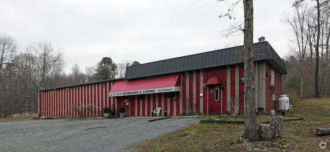
Property Record
1500 W Pulaski Hwy, Elkton, MD 21921

NEARBY LISTINGS FOR SALE OR LEASE
-
-
View all Elkton listings for sale on LoopNet.com
Property Detail
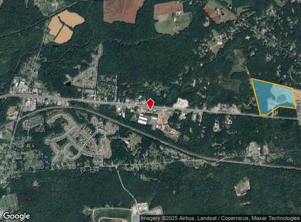
1500 W Pulaski Hwy
03-006271
77.409 AC PULASKI HIGHWAY W OF ELKTON
Commercialnec
Cecil
X
Maryland
24015C0160E
77.41 AC
2025
Cecil County
2025
Baltimore
030903
Philadelphia-Camden-Wilmington, PA-NJ-DE-MD
3,000 SF
DEMOGRAPHICS near 1500 W Pulaski Hwy
1 Mile
3 Mile
5 Mile
2024 Total Population
1,135
13,337
43,831
2029 Population
1,172
13,788
44,999
Pop Growth 2024-2029
+ 3.26%
+ 3.38%
+ 2.66%
Average Age
40
39
40
2024 Total Households
435
4,887
16,259
HH Growth 2024-2029
+ 3.22%
+ 3.40%
+ 2.72%
Median Household Inc
$59,705
$58,154
$69,616
Avg Household Size
2.60
2.60
2.60
2024 Avg HH Vehicles
2.00
2.00
2.00
Median Home Value
$238,695
$235,119
$276,187
Median Year Built
1993
1990
1989
Nearby Places
Map Layers
Map Styles
 Street
 Aerial
- Restaurants
- Banks
- Shops
- Fitness
- Groceries
Nearby Properties
Address
Land Use
TOTAL SIZE
Lot Size
Zoning
Address
Land Use
TOTAL SIZE
Lot Size
Zoning
10,000 SF
50.29 AC
HCHCO
Address
Land Use
TOTAL SIZE
Lot Size
Zoning
28,506 SF
20.23 AC
RM
Address
Land Use
TOTAL SIZE
Lot Size
Zoning
58,410 SF
100.35 AC
M2
Address
Land Use
TOTAL SIZE
Lot Size
Zoning
193,440 SF
36.74 AC
M1
Address
Land Use
TOTAL SIZE
Lot Size
Zoning
116,097 SF
64.11 AC
M1
Address
Land Use
TOTAL SIZE
Lot Size
Zoning
9,920 SF
27.68 AC
M1
Address
Land Use
TOTAL SIZE
Lot Size
Zoning
43,634 SF
3.52 AC
I
Address
Land Use
TOTAL SIZE
Lot Size
Zoning
15,900 SF
230.94 AC
M2
Address
Land Use
TOTAL SIZE
Lot Size
Zoning
201,694 SF
18.98 AC
BI
Address
Land Use
TOTAL SIZE
Lot Size
Zoning
23,800 SF
8.72 AC
BI
Address
Land Use
TOTAL SIZE
Lot Size
Zoning
9,944 SF
98.33 AC
UR
Address
Land Use
TOTAL SIZE
Lot Size
Zoning
121,404 SF
19.65 AC
HC
Address
Land Use
TOTAL SIZE
Lot Size
Zoning
142,582 SF
74 AC
RM
Address
Land Use
TOTAL SIZE
Lot Size
Zoning
4,020 SF
76.79 AC
M2
Address
Land Use
TOTAL SIZE
Lot Size
Zoning
9,930 SF
351.26 AC
SPLIT
Address
Land Use
TOTAL SIZE
Lot Size
Zoning
60,850 SF
11.75 AC
R1
Address
Land Use
TOTAL SIZE
Lot Size
Zoning
77,905 SF
9.22 AC
I
Address
Land Use
TOTAL SIZE
Lot Size
Zoning
2,400.63 AC
OS
Address
Land Use
TOTAL SIZE
Lot Size
Zoning
105,041 SF
9.89 AC
R1
Address
Land Use
TOTAL SIZE
Lot Size
Zoning
170.50 AC
BG
Address
Land Use
TOTAL SIZE
Lot Size
Zoning
38,400 SF
11.42 AC
BI
Address
Land Use
TOTAL SIZE
Lot Size
Zoning
50,819 SF
1.10 AC
C2
Address
Land Use
TOTAL SIZE
Lot Size
Zoning
1,184 SF
101.71 AC
BI
Address
Land Use
TOTAL SIZE
Lot Size
Zoning
1,800 SF
43.92 AC
CM2
Address
Land Use
TOTAL SIZE
Lot Size
Zoning
30.71 AC
MH
Address
Land Use
TOTAL SIZE
Lot Size
Zoning
76,540 SF
20.58 AC
M1
Address
Land Use
TOTAL SIZE
Lot Size
Zoning
50,920 SF
5.01 AC
M1
Address
Land Use
TOTAL SIZE
Lot Size
Zoning
10,169 SF
18.04 AC
M1
Address
Land Use
TOTAL SIZE
Lot Size
Zoning
2,916 SF
139.53 AC
MEA
Address
Land Use
TOTAL SIZE
Lot Size
Zoning
16.10 AC
SPLIT
The World's #1 Commercial Real Estate Marketplace
Connect with us
© 2025 CoStar Group
The information above has been obtained from sources believed reliable. While we do not doubt its accuracy we have not verified it and make no guarantee, warranty or representation about it. It is your responsibility to independently confirm its accuracy and completeness. Any projections, opinions, assumptions, or estimates used are for example only and do not represent the current or future performance of the property. The value of this transaction to you depends on tax and other factors which should be evaluated by your tax, financial, and legal advisors. You and your advisors should conduct a careful, independent investigation of the property to determine to your satisfaction the suitability of the property for your needs.