Property Record
15002 Lasater Rd, Dallas, TX 75253
NEARBY LISTINGS FOR SALE OR LEASE
Property Detail
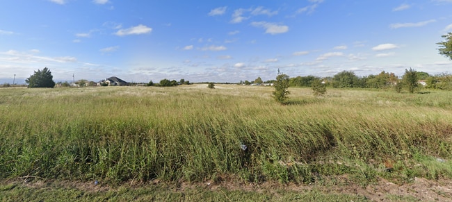
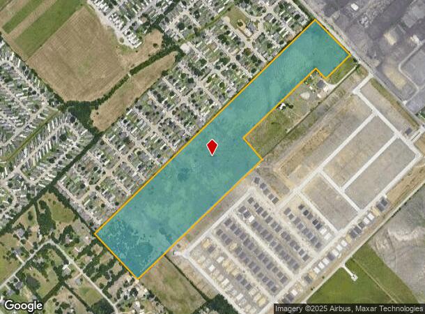
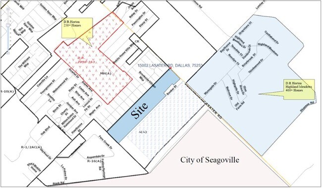
15002 Lasater Rd
Dallas-Fort Worth-Arlington, TX
BLK 8816 TR 6 33.69 ACS VOL98251/9501 DD111898 CO-DALLAS 8816 000 006 3008816 000
00881600000060000
Dallas
Privatepreserveopenspacevacantlandforestlandconservation
Texas
X
6
48257C0150E
33.69 AC
2024
Mesquite/Forney/Terrell
2025
Dallas/Ft Worth
017009
DEMOGRAPHICS near 15002 Lasater Rd
1 mile
3 mile
5 mile
2024 Total Population
12,258
50,669
110,937
2029 Population
12,545
51,042
111,285
Pop Growth 2024-2029
+ 2.34%
+ 0.74%
+ 0.31%
Average Age
30
33
34
2024 Total Households
3,236
14,096
31,982
HH Growth 2024-2029
+ 2.10%
+ 0.60%
+ 0.11%
Median Household Inc
$46,172
$54,183
$61,645
Avg Household Size
3.60
3.40
3.30
2024 Avg HH Vehicles
2.00
2.00
2.00
Median Home Value
$145,438
$178,105
$203,385
Median Year Built
2005
1999
1993
Nearby Places
Map Layers
Map Styles
 Street
 Aerial
Transit
 Traffic
 Biking
Places
Listings with unknown addresses are not visible on the map
- Restaurants
- Banks
- Shops
- Fitness
- Groceries
PUBLIC TRANSPORTATION
AIRPORT
Dallas Love Field
Drive
Walk
Distance
Dallas Love Field
39 min
26.1 mi
Dallas-Fort Worth International
Drive
Walk
Distance
Dallas-Fort Worth International
49 min
39.4 mi
SALE & LEASE HISTORY
LISTING DATE
SALE/LEASE

Sep 24, 2016
For Sale
Nearby Properties
Address
Land Use
TOTAL SIZE
Lot Size
Zoning
Address
Land Use
TOTAL SIZE
Lot Size
Zoning
263,360 SF
42.98 AC
Z237
Address
Land Use
TOTAL SIZE
Lot Size
Zoning
457,110 SF
100.05 AC
Z293
Address
Land Use
TOTAL SIZE
Lot Size
Zoning
200,000 SF
8.11 AC
Z183
Address
Land Use
TOTAL SIZE
Lot Size
Zoning
200,000 SF
8.11 AC
Address
Land Use
TOTAL SIZE
Lot Size
Zoning
290,916 SF
8.24 AC
Address
Land Use
TOTAL SIZE
Lot Size
Zoning
193,000 SF
34.42 AC
Z05
Address
Land Use
TOTAL SIZE
Lot Size
Zoning
257,696 SF
9.62 AC
Address
Land Use
TOTAL SIZE
Lot Size
Zoning
372,456 SF
17.34 AC
Z116
Address
Land Use
TOTAL SIZE
Lot Size
Zoning
109,472 SF
6.98 AC
Address
Land Use
TOTAL SIZE
Lot Size
Zoning
400 SF
50.76 AC
MFA
Address
Land Use
TOTAL SIZE
Lot Size
Zoning
321 SF
40.51 AC
MFA
Address
Land Use
TOTAL SIZE
Lot Size
Zoning
190,150 SF
13.39 AC
Z236
Address
Land Use
TOTAL SIZE
Lot Size
Zoning
106,462 SF
9.58 AC
Z236
Address
Land Use
TOTAL SIZE
Lot Size
Zoning
215 SF
29.95 AC
A
Address
Land Use
TOTAL SIZE
Lot Size
Zoning
123,790 SF
6.68 AC
Z183
Address
Land Use
TOTAL SIZE
Lot Size
Zoning
248 SF
32.79 AC
MFA
Address
Land Use
TOTAL SIZE
Lot Size
Zoning
208 SF
24.50 AC
Z06
Address
Land Use
TOTAL SIZE
Lot Size
Zoning
122,352 SF
6.05 AC
Z46
Address
Land Use
TOTAL SIZE
Lot Size
Zoning
377,133 SF
16.71 AC
Z131
Address
Land Use
TOTAL SIZE
Lot Size
Zoning
88,320 SF
4.48 AC
Z72
Address
Land Use
TOTAL SIZE
Lot Size
Zoning
183 SF
23.14 AC
Z06
Address
Land Use
TOTAL SIZE
Lot Size
Zoning
80,933 SF
7.96 AC
Z05
Address
Land Use
TOTAL SIZE
Lot Size
Zoning
70,000 SF
25.26 AC
Z06
Address
Land Use
TOTAL SIZE
Lot Size
Zoning
216,327 SF
26.31 AC
Address
Land Use
TOTAL SIZE
Lot Size
Zoning
319 SF
37.74 AC
SUP1
Address
Land Use
TOTAL SIZE
Lot Size
Zoning
72,341 SF
13 AC
Z236
Address
Land Use
TOTAL SIZE
Lot Size
Zoning
146 SF
18.02 AC
MFA
Address
Land Use
TOTAL SIZE
Lot Size
Zoning
156 SF
17.11 AC
MFA
Address
Land Use
TOTAL SIZE
Lot Size
Zoning
96 SF
14.18 AC
I2
Address
Land Use
TOTAL SIZE
Lot Size
Zoning
89,044 SF
5.04 AC
Z163
The World's #1 Commercial Real Estate Marketplace
Connect with us
© 2026 CoStar Group
The information above has been obtained from sources believed reliable. While we do not doubt its accuracy we have not verified it and make no guarantee, warranty or representation about it. It is your responsibility to independently confirm its accuracy and completeness. Any projections, opinions, assumptions, or estimates used are for example only and do not represent the current or future performance of the property. The value of this transaction to you depends on tax and other factors which should be evaluated by your tax, financial, and legal advisors. You and your advisors should conduct a careful, independent investigation of the property to determine to your satisfaction the suitability of the property for your needs.