Property Record
15005 Plank Rd, Baker, LA 70714
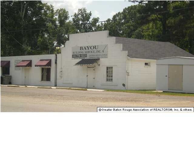

Property Detail
15005 Plank Rd
Baton Rouge, LA
WARD: 2-2, SUBDIVISION: PAULSEN-MUNDINGER TRACT, LOT: 4-A. LOTS 4-A RESUB OF LOT 4 OF T C PAULSEN AND J J MUNDINGER PROPERTY
01216821
East Baton Rouge
Storesoffices
Louisiana
B and X Area of moderate flood hazard, usually the area between the limits of the 100-year and 500-year floods.
4-a
2025
0.36 AC
2025
Greater Baton Rouge N
004204
Baton Rouge
NEARBY LISTINGS FOR SALE OR LEASE
DEMOGRAPHICS near 15005 Plank Rd
1 mile
3 mile
5 mile
2025 Total Population
3,147
19,993
51,046
2030 Population
3,131
19,855
50,807
Pop Growth 2025-2030
(0.51%)
(0.69%)
(0.47%)
Average Age
39
40
40
2025 Total Households
1,196
7,474
18,828
HH Growth 2025-2030
(0.50%)
(0.76%)
(0.50%)
Median Household Inc
$63,098
$47,913
$49,632
Avg Household Size
2.50
2.50
2.50
2025 Avg HH Vehicles
2.00
2.00
2.00
Median Home Value
$148,561
$155,601
$171,024
Median Year Built
1983
1978
1978
Nearby Places
Map Layers
Map Styles
 Street
 Aerial
Transit
 Traffic
 Biking
Places
Listings with unknown addresses are not visible on the map
- Restaurants
- Banks
- Shops
- Fitness
- Groceries
PUBLIC TRANSPORTATION
AIRPORT
Baton Rouge Metro Ryan Field
Drive
Walk
Distance
Baton Rouge Metro Ryan Field
6 min
4.0 mi
Freight Ports
Port of Greater Baton Rouge
Drive
Walk
Distance
Port of Greater Baton Rouge
25 min
14.8 mi
SALE & LEASE HISTORY
LISTING DATE
SALE/LEASE

May 10, 2018
For Sale
Aug 28, 2018
For Lease
Nearby Properties
Address
Land Use
TOTAL SIZE
Lot Size
Zoning
Address
Land Use
TOTAL SIZE
Lot Size
Zoning
186,000 SF
23.51 AC
Address
Land Use
TOTAL SIZE
Lot Size
Zoning
45,480 SF
2.19 AC
Address
Land Use
TOTAL SIZE
Lot Size
Zoning
Address
Land Use
TOTAL SIZE
Lot Size
Zoning
34,310 SF
7.74 AC
Address
Land Use
TOTAL SIZE
Lot Size
Zoning
36.32 AC
Address
Land Use
TOTAL SIZE
Lot Size
Zoning
72,300 SF
24.63 AC
Address
Land Use
TOTAL SIZE
Lot Size
Zoning
1.42 AC
Address
Land Use
TOTAL SIZE
Lot Size
Zoning
Address
Land Use
TOTAL SIZE
Lot Size
Zoning
44,200 SF
6.53 AC
Address
Land Use
TOTAL SIZE
Lot Size
Zoning
16,583 SF
5.61 AC
Address
Land Use
TOTAL SIZE
Lot Size
Zoning
4,884 SF
10.65 AC
Address
Land Use
TOTAL SIZE
Lot Size
Zoning
2.70 AC
Address
Land Use
TOTAL SIZE
Lot Size
Zoning
2.48 AC
Address
Land Use
TOTAL SIZE
Lot Size
Zoning
9,800 SF
3.60 AC
Address
Land Use
TOTAL SIZE
Lot Size
Zoning
16,102 SF
1.26 AC
Address
Land Use
TOTAL SIZE
Lot Size
Zoning
6,489 SF
0.74 AC
Address
Land Use
TOTAL SIZE
Lot Size
Zoning
13,225 SF
1.34 AC
Address
Land Use
TOTAL SIZE
Lot Size
Zoning
1.08 AC
Address
Land Use
TOTAL SIZE
Lot Size
Zoning
29,609 SF
17.39 AC
Address
Land Use
TOTAL SIZE
Lot Size
Zoning
4.77 AC
Address
Land Use
TOTAL SIZE
Lot Size
Zoning
32,250 SF
5 AC
Address
Land Use
TOTAL SIZE
Lot Size
Zoning
53,200 SF
5.41 AC
Address
Land Use
TOTAL SIZE
Lot Size
Zoning
10.17 AC
Address
Land Use
TOTAL SIZE
Lot Size
Zoning
41,375 SF
5 AC
Address
Land Use
TOTAL SIZE
Lot Size
Zoning
16,799 SF
1.53 AC
Address
Land Use
TOTAL SIZE
Lot Size
Zoning
14.03 AC
Address
Land Use
TOTAL SIZE
Lot Size
Zoning
55,503 SF
5.34 AC
Address
Land Use
TOTAL SIZE
Lot Size
Zoning
12,900 SF
4.66 AC
Address
Land Use
TOTAL SIZE
Lot Size
Zoning
40,687 SF
3.71 AC
Address
Land Use
TOTAL SIZE
Lot Size
Zoning
13,650 SF
1.53 AC
The World's #1 Commercial Real Estate Marketplace
Connect with us
© 2026 CoStar Group
The information above has been obtained from sources believed reliable. While we do not doubt its accuracy we have not verified it and make no guarantee, warranty or representation about it. It is your responsibility to independently confirm its accuracy and completeness. Any projections, opinions, assumptions, or estimates used are for example only and do not represent the current or future performance of the property. The value of this transaction to you depends on tax and other factors which should be evaluated by your tax, financial, and legal advisors. You and your advisors should conduct a careful, independent investigation of the property to determine to your satisfaction the suitability of the property for your needs.